
Could this Baigong Pipe be Evidence of an advanced Chemical Fuel Facility?

A few years ago, researchers were perplexed by a series of archaeological discoveries unearthed around Qinghai Province near Mount Baigong near the city of Delingha, in southwestern China.
The mystery has mainly been remained unexplained to this day, with significant evidence pointing to the claims by ancient astronaut theorists.

In 2002, researchers were shocked to discover a series of well-arranged metallic pipe-like structures embedded in the rocks around Mount Baigong, aka white White Mountain. The 150.000 year-old pipelines were discovered next to Qadim Basin, located at the foothills of the Himalayan highlands.
The harsh climate of this area has made it inhospitable throughout human history, and there is scant evidence of human settlement here, even today where only herders quickly pass through the place while moving to fertile pastures down south.
The origin of these Baigong Pipelines and who built them are still a mystery. The most important discovery was a 50-60 meter high pyramid-like protrusion. This protrusion is surrounded by a system of well-organized pipe-like structures that lead to Lake Toson Hu, a saline water lake approximately 300 feet away.

The outcropping has three entrances, two of which have collapsed, leaving the third to lead to a dug-out cave with embedded pipes in the rocky inner floor and walls.
This discovery and the outcropping, lines, and piping network that connects it to Lake Toson Hu perplexed researchers, especially since the outcropping is only 300 feet from a fresh-water lake.
Why did anyone choose a salt-water lake and construct a complex piping network that connects it to the outcropping? Was this any ancient research center? Or some old extraterrestrial facility or base?

There are multiple pipe sizes used in the pipeline complex, with the big pipes measuring up to 1.5 feet in diameter and the trim lines measuring only a few inches. The tubes that comprise this system are named the Baigong Pipes and are officially known as the Bai-Gongshan Iron Pipe.
In the eyes of archaeologists and historians, the Baigong Pipes fit well into the textbook description of ancient objects found Out-of-Place. The Beijing Institute of Geology used radiocarbon dating to show that these iron pipes were smelted around 150,000 years ago.
And if they were created by humans, history as we know it would have to be reevaluated. The researchers used thermoluminescence to assess how long a crystalline mineral had been exposed to sunlight or heated. Humans were assumed to have inhabited the area for the past 30,000 years ago.

Even in the area’s known history, the only humans there were nomads whose way of existence did not leave any such structures behind.
Though some have attempted to explain the pipes as a natural occurrence, Yang Ji, a researcher at the Chinese Academy of Social Sciences, told “Xinhua” that intelligent beings may have constructed the pyramid.

He said that extraterrestrials from the distant past could be responsible, adding that this theory is understandable and worth looking into but scientific means must be employed to prove whether or not it is true.
Another hypothesis is that it was constructed by prehistoric human civilization (like described in the Silurian Hypothesis by NASA scientists) using techniques lost to subsequent humans.

According to the head of the publicity department at the local Delingha administration, the pipes were analyzed at a local smelters. Just 8% of the material could not be identified from other types of material. The remaining components were made of ferric oxide, silicon dioxide, and calcium oxide.
The formation of silicon dioxide and calcium oxide results from extensive interaction between the iron and the surrounding sandstone, indicating that the pipes are thousands of years old. Engineer Liu Shaolin, who did the analysis, told Xinhua that this result has made the site even more mysterious.
A geology researcher from the China Earthquake Administration named Zheng Jiandong informed the state-run newspaper “People’s Daily” in 2007 that some of the pipes were highly radioactive, adding to the mystification.

The pipes could also be fossilized tree roots, according to another hypothesis. Scientists discovered plant detritus and what appeared to be tree rings in a study of the lines, according to Xinmin Weekly in 2003.
The discovery was linked to a geological idea that tree roots can undergo diagenesis (the change of soil into rock) and other processes that result in iron deposits under specific temperatures and chemical conditions.
The Xinmin Weekly’s reporting on the root cause of the Baigong Pipes can be traced back to this article, and none of the research includes citations. Regarding the Baigong pipes, there is no definitive knowledge of how solid this theory is.
Global Club / Crickey Conservation Society 2023.
Oceanic White Tip Shark population in Decline

Oceanic white-tip sharks are large, pelagic sharks found in tropical and subtropical oceans throughout the world. They live offshore in deep water, but spend most of their time in the upper part of the water column near the surface.
Oceanic white tip sharks are long-lived, late maturing, and have low to moderate productivity. The main threat to oceanic white tip sharks is by-catch in commercial fisheries combined with demand for its fins. Almost 90% of the species disappeared during the last decades.

They are frequently caught in pelagic long line, purse seine, and gill-net fisheries worldwide and their fins are highly valued in the international trade for shark products.
As a result, their populations have declined throughout its global range. In 2018, NOAA Fisheries listed the species as threatened under the Endangered Species Act.
Information on the global population size of the oceanic white tip is lacking. However, several lines of evidence suggest that the once common and abundant shark has experienced declines of potentially significant magnitude due to heavy fishing pressure.

For example, the oceanic white tip has declined by approximately 80 to 95% across the Pacific Ocean since the mid-1990’s. Substantial abundance declines have also been estimated for the Atlantic Ocean, including an 88% decline in the Gulf of Mexico due to commercial fishing.
Given their life history traits, particularly their late age of maturity and low reproductive output, oceanic white tip sharks are inherently vulnerable to depletion’s, with low likelihood of recovery.
Additional research is needed to better understand the population structure and global abundance of the oceanic white tip shark.

Oceanic white tip sharks are large-bodied sharks with a stocky build, and have a distinctive pattern of mottled white markings on the tips of their dorsal, pectoral, and tail fins.
These markings are why they are called “white-tip” sharks.
Their dorsal fins are rounded and their pectoral fins are long and paddle-like. The color of their bodies varies depending on where they live. They are generally-grayish bronze to brown, while their undersides are whitish with some individuals having a yellow tinge.

The oceanic white tip shark are considered a top predator, eating at the top of the food chain. They are opportunistic, feeding primarily on bony fish and cephalopods, such as squid.
However, they also reportedly feed on large pelagic sport-fish (e.g., tuna, marlin), sea birds, other sharks and rays, marine mammals, and even garbage.
The oceanic white tip shark is found throughout the world in tropical and sub-tropical waters. It is a pelagic species, generally found offshore in the open ocean, on the outer continental shelf, or around oceanic islands in deep water areas.

Although they can make deep dives and have been recorded up to 1,082 meters (3,549 feet) deep, they typically live in the upper part of the water column, from the surface to at least 200 meters (656 feet deep).
Oceanic white tip sharks have a strong preference for the surface mixed layer in warm waters above 20°C, and are therefore considered a surface-dwelling shark.
Oceanic white tip sharks are estimated to live up to 25 years, although it is thought that individuals may live to be much older (up to 36 years).

Female oceanic white tip sharks reach maturity between 6 and 9 years of age (depending on geographic location) and give birth to live young after a very lengthy gestation period of 10 to 12 months.
The reproductive cycle is thought to be biennial, with sharks giving birth on alternate years to litters ranging from 1 to 14 pups (average of 6). There is also a likely correlation between female size and number of pups per litter, with larger sharks producing more offspring.
The primary threat to the oceanic white tip shark is incidental by-catch in commercial fisheries, including long lines, purse seines, and gill-nets (among other gear types).

Because of their preferred distribution in warm, tropical waters, and their tendency to remain at the surface, oceanic white tip sharks have high encounter and mortality rates in fisheries throughout their range.
Their large, distinct fins are also highly valued in the international shark fin trade.
NOAA Fisheries / Crickey Conservation Society 2023.
Sweden suffering from Wild Boar Invasion

Several decades after their re-introduction, Sweden’s wild boar population has exploded from hundreds to hundreds of thousands, becoming the single largest reason for domestic hunting dog injuries, as well as a bane for the nations crop farmers.
In recent years, Sweden’s wild boar population has exploded to become a threat to humans and dogs, as well as a detriment to the Nordic country’s agricultural sector.

In December, a boar rampaged through a McDonald’s restaurant in the city of Uppsala north of Stockholm. In the summer, a hunter in southern Sweden died after being gored by a boar, which became the country’s first such fatality in modern history.
Boars have caused more than 5,100 traffic accidents in 2022 alone.
Last and perhaps most important, they destroyed a massive 84,500 tons of crops in 2020, causing losses of 1.1 billion kronor ($100 million) and creating serious insurance problems for farmers. Stories of farmers having their crops destroyed by boars have become a common sight in Swedish media.

A study presented in the country’s leading nationwide specialist magazine for farmers gave a dull picture of the Swedes’ relationship with their wild boar, as six out of ten respondents said its population was too big, with their share reaching 80% in boar-rich regions.
Yet another reason for keeping the wild boar population down is to keep African swine fever at bay; the disease is fatal for wild boar and domestic pigs alike.
The disease has already established itself in Sweden’s vicinity — in Poland, Germany and the Baltic countries. Its spread to Sweden, painted as a worst-case scenario, would pose a threat to the nation’s pork industry as well.

Wild boar has long been a natural part of the Swedish fauna, having thrived in Nordic forests since pre-historic times. At some point during the 18th century, the wild boar was exterminated and it was not until the 1940’s until it was reintroduced — and only in enclosures.
However, escapes and illegal releases from captivity have since occurred, which made the boar population skyrocket as it spread across the country.
In the early 1980’s, there were fewer than 100 free-living wild boars in the country. The current boar population is estimated at 300,000 and is growing despite the annual shooting of tens of thousands of the animals.
Sputnik / Crickey Conservation Society 2023.
Nikon Coolpix P900 best Camera money can buy

There are nice cameras and then there are insanely nice cameras. Nikon’s Coolpix P900 is one of the insanely nice cameras, although in the world of photography it comes with a pretty affordable price tag.
For $596 you can own a camera with zoom capabilities that far surpass the competition, in fact this camera can even capture the movement of the moon.

Nikon’s point and shoot camera, the Coolpix P900, recently went viral on YouTube after German-based nature-lover Lothar Lenz captured stunning video footage of the moon moving using the camera’s 83x optical zoom lens.
Since the video went viral people have been quick to point out that the camera is actually capturing the rotation of the Earth. The moon rotates around the Earth in the same direction and completes one full rotation in a little less than 28 days.
From earth it looks like the moon is completely still, but when you use the zoom feature on this camera you can suddenly see something you couldn’t before.

Both Earth and the Moon are moving all of the time; Earth is clocking speeds of 1,000 miles per hour. We don’t feel how fast we are moving because the speed is so constant.
The camera has gotten a lot of attention thanks to its massive 24-2000mm lens, which literally puts this camera in a class all by itself. It’s not just the impressive zoom feature that earns this camera such great reviews.
The Coolpix P900 also comes with GPS, Wi-Fi, manual exposure controls, twin dial operation and so much more.
Fancy Work / ABC Flash Point News 2023.
Zero Cost hacks to Grow your own Food

When speaking to people who don’t already grow their own, one of the main factors that comes up is cost. People worry that it will be expensive to get started with the process of growing their own food.
But a vegetable garden or kitchen garden does not need to cost the earth. In fact, you need no money at all for many of the basic elements you need to get started.

So to help new gardeners get started on the road to greater resilience and self-sufficiency – here are some zero cost tips for starting a vegetable garden right now.
First of all, it is important to remember that most of what plants need to grow is already there. Plants need sunshine, nutrients from the air and soil, and water.
While gardening can sometimes seem a complex business, nature already provides a lot of what you need. You won’t need much, other than seeds, time and a little effort, to get growing.

When you start a vegetable garden, what you are doing is essentially manipulating the natural world so it can better meet your needs. But the mistake many gardeners make is forgetting that when you take from nature – you have to give back.
In an organic garden, one of our goals is to make sure nature’s cycles keep on turning, while we still generate the yields we need. If we don’t think about nature’s cycles, and about giving back, we risk creating a garden that thrives for only a brief period of time.
So before you even think about making your vegetable garden and sourcing your seeds, it is important to think about how you will keep your garden healthy and productive. You need to think not just about right now, but also about the long term.

The goal with any new growing system should be to create a garden that can continue to thrive, evolve and grow for years to come. Fortunately, making sure that you provide for the needs of your garden long term need not cost you a thing.
So let’s take a look at how you can ensure enduring health and fertility in your garden without necessarily even spending a dime. Composting is one of the most important processes in an organic garden.
It is the method we use to ‘recycle’ good waste and other biodegradable materials and return the nutrients they contain to our growing areas. Before you do anything else, therefore, it is a great idea to set up your own composting system.

It does not matter how large or small a plot you have. You may even have no garden at all. But you can always compost, even if it is only on a very small scale.
By setting up a composting system on your property, you can boost your self-reliance, and build a growing system that you can maintain for free (or for next to nothing) for years to come.
Composting is not the only method gardeners can use to return nutrients to the system. There are also other ways to use free resources from your environment to make your own free fertilizers and fertility boosters for your garden.

Another important thing to think about before you start your vegetable garden is whether you will need to water it manually. The first thing that you can do is think about how you can keep around the rainfall that does fall on your property
In most locations, it is likely, even when growing outdoors in the open, that you will have to water your vegetable garden for at least part of the year. Even in higher rainfall areas, there can often be dry periods during the spring or summer months.
The more water you can catch and keep on your property, the better. We can influence how much water we catch and store in our gardens.

If you are feeling really ambitious, you could even consider creating a zero cost greenhouse. Or another under-cover growing area for your garden.
You could make a greenhouse using items that might otherwise be thrown away, such as old windows and doors from a demolition or renovation project. You can use a range of other free materials too – from plastic bottles, to glass bottles, to reclaimed PVC piping and more.
Even if you don’t have a garden, you could start a vegetable garden, right now, inside your home.

A sunny windowsill can be enough to get started with container gardening. No matter where you live, it is possible for you to grow at least a small proportion of your own food.
When it comes to seed trays, pots and planters, you can, again, make use of what is available to you already, rather than going out and buying anything new. Plastic food packaging – pots, trays and bottles – can have a wide range of uses when it comes to getting started with your vegetable garden.
You can also make seedling pots from old toilet roll tubes. Not only are these a free and widely available resource, they can also be planted along with your seedlings in your new vegetable garden. So they are a great example of one of the biodegradable plant pots you can make at home.

Small cardboard boxes, and recycled paper made into papier maché pots with flour paste, are other interesting (and zero cost) options.
When it comes to larger containers and planters, there are a range of further zero cost options to consider. There is almost no end to the options you could consider – from the drawers from old wooden furniture, to washing machine drums, to old pots and pans… the list goes on.
By now, you should see just how possible it is to use natural and free resources to create your vegetable garden, no matter how large or small. All that now remains is to source the seeds and plants you need to actually populate your new garden.

There may well be some small expense involved in actually sourcing the seeds and plants you want. To save money, remember that it is always cheaper to use slow solutions and grow from seed. So do this rather than buying in plug plants or fully grown plants for your garden.
But before you head out and buy your seeds, it could be worthwhile trying to source seeds and plants for free. Before you make any purchasing decisions, it is always good to do an inventory to see what you already have in your garden and in your home.
You might also be able to plant, for example, potatoes sourced from a local farmer’s market or local organic supplier. If in doubt, it won’t hurt to give things a go and see what germinates and grows.

Another thing to consider is whether you can save seeds from food you buy to plant. (Organic tomato seeds, or squash or pumpkin seeds, for example). You may also be able to regrow vegetables from scraps.
It is also worthwhile looking around your neighborhood and asking around to see if anyone you know would be willing to give you plants or plant cuttings to populate your garden. Home growers often grow too many seedlings and frequently have young plants or cuttings they would be willing to give away.

If you are new to gardening, getting to know some more experienced gardeners can often pay dividends – not only in terms of seeds and free plants, but also in terms of their invaluable knowledge and expertise.
Reach out to those you already know. But also consider reaching out online to other gardeners close to where you live, to see how they might be able to share resources and advice to help you set up your new garden. If in doubt, it never hurts to ask.
Rural Sprout / Crickey Conservation Society 2022.
Curacao vol Dynamiek en Traditie sinds 1499

Dynamiek, Spirituele Tradite en Humanitaire Ontwikkeling zijn de tref woorden van Crickey Amigu di Natura.
Nederlandse versie Inzet Natuur CAdN Beweging :
- Invoeren bindend Referendum
- Eerlijke verdeling Welvaart
- De Groot- Vervuiler Betaald of neemt Passende Eco Maatregelen
- Geen Winstoogmerk Basis Behoefte * Zorg/Wonen/Water/Energie en Onderwijs.
- Doorbreken Politiek Bancair System
- Aanpakken Multi-Nationals die oneindig Dieviezen Weg mogen Sluizen
- Beeindigen “Food Waste Dumping” bij Hotels, Restaurants en Supermarkets
Het verbeteren van de geldverslindende mensheid begint met uzelf, door een naaste of Hulpbehoevende te Ondersteunen in plaats van financieel uit te Melken en afhankelijk te stellen.

Het ontwikkelen in mangrove gebied is wereldwijd verboden, maar op Curacao mag Corendon gewoon kappen en bouwen middenin dit soort beschermde gebieden, waarmee de kringloop van de voedsel keten doelbewust afgebroken wordt?
Alsof dit al niet erg genoeg blijkt te zijn, wordt de bouw van fase 2 ($65 miljoen) met pensioen geld van de burger neergezet. De Turkse investeerder die er zelf geen cent inzet verbied vervolgens lokalen het gebied te bezoeken (verboden toegang krijgt men te horen bij de poort)?

Om dit gedrag een beetje cache te geven wordt een bar waar alcohol geschonken maar Mondi (natuur) Bar genoemd. APC is de ontwikkelaar, die ook hier, evenals de afbraak plannen van het Plaza Hotel bij Punda, zich zeer schandalig opsteld? Er zou asbest aangetroffen zijn in het beton van het traditionele gebouw!
De twee mega pieren om de achtergrond van Corendon koste het volk fl.150 miljoen, met no return on investment voor de staatskas? Armoede is onnodig in deze Tijd van Historische Welvaart, maar op deze wijze van ontwikkelen zit niemand te wachten op Curacao.

Een nieuw ziekenhuis koste het volk fl.750 miljoen, maar deze kan geeneens op eigen benen staan, moet met tientallen miljoenen subsidie (volksgeld) per jaar overeind gehouden worden, terwijl het zonder te formaliseren onteigend werd.
Daarnaast betaalt de SVB nu driemaal de hoofdprijs om lokale zieken in behandeling te laten nemen. Dit zal leiden tot de ondergang van de SVB, waarbij het volk niet meer verzekerd zal tegen ziekten en/of ziekenhuis opname?
Het door Nederland (Den Haag en Cft) aangestuurde beleid en hervormings maatregelen laten veel te wensen over, met de gedachte dat roven en plunderen toch tot de verleden koloniale tijden behoorde!

Verder staat milieu diensten het gewoon toe dat er een zwaar vervuilende motor yacht haven aangelegd gaat worden bij Zakito nabij Marriott en Hilton. Ook dit weer ten koste van koralen en weer onbeschermd eeuwen oude mangrove gebieden?
Ook moest er voor honderden miljoenen een nieuwe aankomst hal voor de KLM, TUI en American Airlines worden gebouwd, Wordt beheerd door Swissport, maar het onderhoud wordt door CAP met de luchthaven belasting betaald.
Ook hier dus geen return on investment voor het ingestoken belasting geld, als CAP alle airport tax mag gebruiken voor eigen doeleinden?

En de politici en media maar klagen over corruptie (de pot verwijt de ketel) op de Caribische eilanden voor de kust van Venezuela. Maar goed commercieel toerisme werd door Nazi Duitsland verzonnen, om destijds (WW II) de Fransen in Parijs wat geld te laten verdienen om zo de oorlogs propaganda op peil te houden.
Op Curacao gaan we dan nog een stapje verder en hebben we anno 2022 te maken met massa toerisme wat massa werkeloosheid en armoede (en dus criminaliteit) met zich meebrengt. De horeca en bouw sectoren werken met goedkope onverzekerde (vaak illegale) Venezolaanse vluchtelingen.

Alle publieke standen worden geprivatiseerd door ligstoel verhuurders en andere vormen van ecologisch onverantwoordelijke toedoeningen waar mogelijk het lokale volk later ook weer de toegang ontnomen wordt?
Voor de drugs smokkel van de Amsterdamse misdaad netwerken werken velen zolas Citro en de Coast Guard samen om de markt te controleren. Toch wordt de handel verstopt tussen de bagage van de niets vermoedende toeristen die met charters heen en weer naar Klein Curacao gevaren worden.

Vissers klagen steen en been over de nieuwe ontwikkelingen, waarbij deze vis quotas krijgen opgelegd, terwijl toeristen de stranden van Klein Curacao bestormen en in beslag nemen, waarbij tientallen palapa’s en een uitkijktoren, die zonder rechtmatige bouwvergunning werden neergezet, deze mogelijkheid bieden.
Alle factoren bij elkaar gebonden geven hiermee duidelijk aan hoe ernstig en nijpend de situatie achter de schermen op Curacao werkelijk is. Maar omdat het om miljarden per jaar gaat blijven de toonaangevende instanties muisstil, want een brede ontwikkeling is goed voor de Koninkrijks eilanden.
Crickey Conservation Society 2007-2022
Large Venomous Spiders are swarming part of Australia

Although there’s a whole trope about Australia being some scary place full of buff cows, stinging trees, and hawks that literally spread their own fires, we all know it’s actually a wonderful place to live.
Even when parts of it are swarming with lethally venomous Funnel-web spiders; as they are right now, creating scenes pulled directly out of a Stephen King novel. At least the country’s beaches are still great when they’re not infested with snakes.

Australia, also experiences upticks in spiders when the weather grows warmer every year for summer. Thanks to this year’s floods, however, the spider hordes are especially large and invasive as they seek dry land.
Many of the spiders invading peoples’ property are, unfortunately, also exceptionally venomous.
Australian Reptile Park Head of Reptiles and Spiders Dan Rumsey told Sky News Australia that the invading Sydney Funnel-web spiders are potentially one of the most dangerous spiders on the planet, not just here in Australia.

The Sydney Funnel-web spiders (or Atrax robustu) Rumsey’s referring to are tarantula-like spiders native to the area. And while the spiders aren’t necessarily aggressive, they do still carry extremely toxic venom; in fact, it’s one of the most lethal for humans in existence.
On top of that, Funnel-webs are notorious for seeking dry patches of land in people’s backyards. Or even their homes. Which, of course, makes the arachnids ten times scarier.
Despite the freak factor here, however, Australia hasn’t recorded a single death by Funnel-web since scientists developed an antivenom. And people even generally seem to be able to recover from bites just fine as long as they get to a hospital in time.

The floods that stood as the precursor for the spider swarms, on the other hand, are quite dangerous: 40,000 people have had to evacuate their homes because of them.
Although, on the bright side, the spiders are likely to disperse when the landscape dries up, which will be the same time people return to their homes.
Nordist / Crickey Conservation Society 2022
Puma Punku Bolivia the Gateway to the Sun

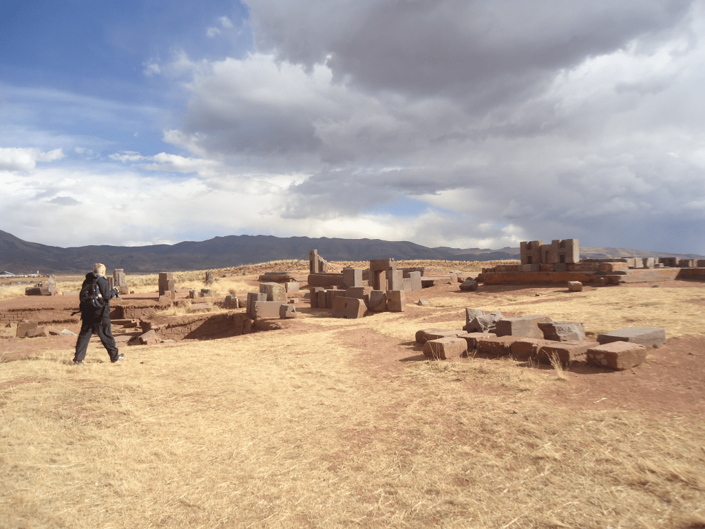
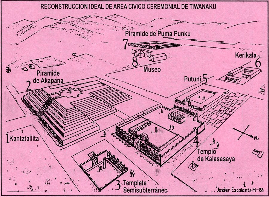
Puma Punku (Aymara and Quechua which literally means ‘Gate of the Puma’) is a 6th-century T-shaped and strategically aligned man-made terraced platform mound with a sunken court and monumental structure on top that is part of the Pumapunku complex, at the Tiwanaku Site near Tiwanacu, in western Bolivia.
The Pumapunku complex is an alignment of plazas and ramps centered on the Pumapunku platform mound. Today the monumental complex on top of the platform mound lies in ruins.

It is believed to date to AD 536. After Akapana, which is believed to be “Pumapunku’s twin”, Pumapunku was the second most important construction in Tiwanaku. Among all the names for the areas in Tiwanaku only the names “Akapana” and “Pumapunku” have historical relevance.
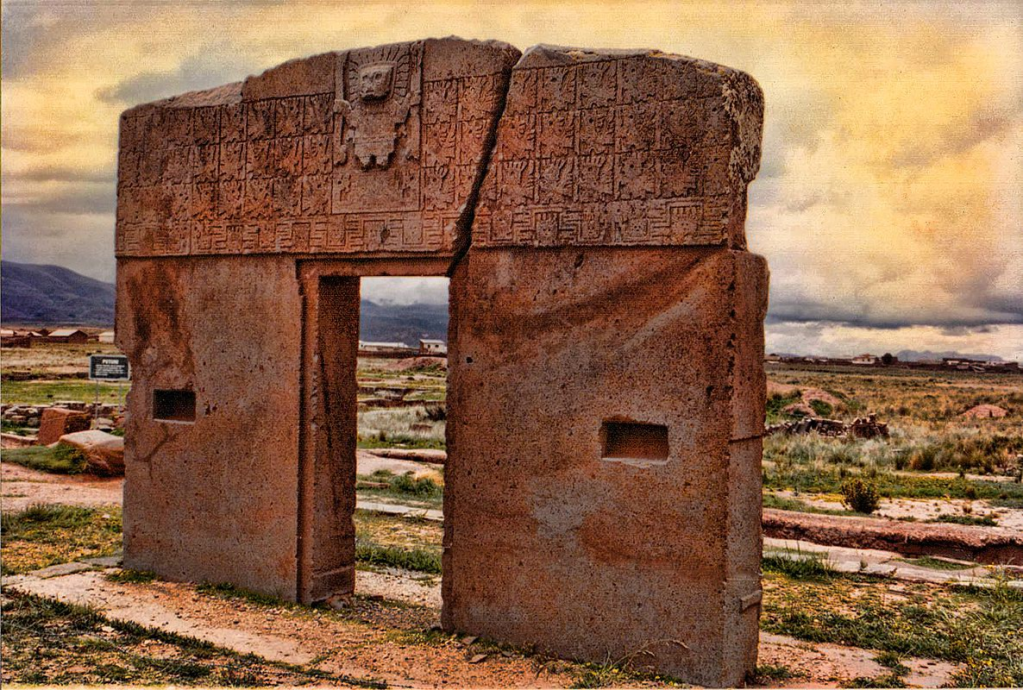
At Pumapunku several miniature gates which are perfect replicas of once standing full-size gateways were found. Additionally to these miniature gateways, likely, at least five gateways (and several blind miniature gateways) were once (or were intended to be) integrated into the Pumapunku monumental complex.
The foundation platform of Pumapunku supported as many as eight andesite gateways. The fragments of five andesite gateways with similar characteristics to the Gateway of the Sun were found.

Tiwanaku is significant in Inca traditions because it is believed to be the site where the world was created. In Aymara, Puma Punku’s name means “Gate of the Puma”.
The Pumapunku complex consists of an unwalled western court, a central unwalled esplanade, a terraced platform mound that is faced with stone, and a walled eastern court.
At its peak, Pumapunku is thought to have been “unimaginably wondrous,” adorned with polished metal plaques, brightly colored ceramic and fabric ornamentation, and visited by costumed citizens, elaborately dressed priests, and elites decked in exotic jewelry.
Current understanding of this complex is limited due to its age, the lack of a written record, and the current deteriorated state of the structures due to treasure hunting, looting, stone mining for building stone and railroad ballast, and natural weathering.
When the Spanish arrived at Tiwanaku there was still standing architecture at Pumapunku. Bernabé Cobo reports that one Gateway and one “window” was still standing on one of the platforms.
The Pumapunku is a terraced earthen mound faced with blocks. It is 167.4 meters (549 feet) wide along its north–south axis and 116.7 meters (383 feet) long along its east–west axis.

On the northeast and southeast corners of the Pumapunku, it has 20-metre (66-foot) wide projections extending 27.6 meters (91 feet) north and south from the rectangular mound.
The eastern edge of the Pumapunku is occupied by the Plataforma Lítica. This structure consists of a stone terrace 6.8 by 38.7 meters (22 by 127 feet) in dimension.
This terrace is paved with multiple enormous stone blocks. It contains the largest stone slab in the Pumapunku and Tiwanaku Site, measuring 7.8 metres (26 feet) long, 5.2 metres (17 feet) wide and averages 1.1 m (3 ft 7 in) thick.
Based on the specific gravity of the red sandstone from which it was carved, this stone slab is estimated to weigh 131 tonnes (144 short tons). The remarkable aspects of the sandstone slabs, including their size and smooth surfaces have drawn comments for several centuries.
The other stonework and facing of the Pumapunku consists of a mixture of andesite and red sandstone. Pumapunku’s core consists of clay, while the fill under parts of its edge consists of river sand and cobbles instead of clay. Excavations documented three major building epochs plus repairs and re-modeling.
The area within the kilometer separating the Pumapunku and Kalasasaya complexes was surveyed using ground-penetrating radar, magnetometry, induced electrical conductivity, and magnetic susceptibility.

The geophysical data collected from these surveys and excavations indicate the presence of numerous man-made structures in the area between the Pumapunku and Kalasasaya complexes.
These structures include the wall foundations of buildings and compounds, water conduits, pool-like features, revetments, terraces, residential compounds, and widespread gravel pavements, all of which are buried and hidden beneath the modern ground surface.
After the area was mapped with a drone in 2016, the results showed the site has a size of seventeen hectares of which only two hectares are unearthed. There are two additional platforms still underground.

Archaeologists dispute the transport of these stones was by the large labor force of ancient Tiwanaku. Several conflicting theories attempt to imagine the ways this labor force transported the stones, although these theories remain speculative.
Two common proposals involve the use of llama skin ropes, and the use of ramps and inclined planes. In assembling the walls of Pumapunku, each stone interlocked with the surrounding stones. The blocks were fit together like a puzzle, forming load-bearing joints.
The precise cuts suggest the possibility of pre-fabrication and mass production, technologies far in advance of the Tiwanaku’s Inca successors hundreds of years later. Some of the stones are in an unfinished state, showing some of the techniques used to shape them.
Pumapunku was a large earthen platform mound with three levels of stone retaining walls. Its layout is not square in plan, but rather T-shaped.
To sustain the weight of these massive structures, Tiwanaku architects were meticulous in creating foundations, often fitting stones directly to bedrock or digging precise trenches and carefully filling them with layered sedimentary stones to support large stone blocks.
Modern engineers argue that base of Pumapunku was constructed using a technique called layering and depositing. By alternating layers of sand from the interior and layers of composite from the exterior, the fills overlap at the joints, grading the contact points to create a sturdy base.

The architectural historian Jean-Pierre Protzen from University of California, Berkeley states that in the past it often haven been argued that among the buildings at Ollantaytambo the monumental structures (e. g. the Wall of the six monoliths) were the work of the earlier Tiwanaku culture and have been reused by the Incas.
At least five gateways (and several blind miniature gateways) were once (or were intended to be) integrated into the Pumapunku monumental complex.
The foundation platform of Pumapunku supported as many as eight andesite gateways. The fragments of five andesite gateways with similar characteristics to the Gateway of the Sun were found.
There also exist miniature gateways at Pumapunku which are perfect replicas of once standing monumental full-sized gateways. When reducing the full-sized monumental architecture to miniature architecture the Tiahuanacans applied a specific formula.
There also exist replicas of larger monumental structures. For example it has been shown that the much-admired carved block known as the “Escritorio del Inca” is an accurate and reduced-scale model of full-scale architecture.
Some of these model stones like little Pumapunku are not isolates stones but, rather, seem to fit in the context of other stones and stone fragments. According to Protzen and Nair the fact that many of these model stones were executed in multiple exemplars bespeaks mass production.

At Pumapunku and other areals of Tiwanaku such as Kantatayita doubly curved lintels with complicated surfaces were found.
Jean-Pierre Protzen and Stella Nair point out that the “steep parabolic curve” of the doubly curved lintels (like the one of the Kantatayita lintel) would be difficult to replicate for modern stonemasons (would tax any stonemason’s skills today)
There are at least two monoliths associated with the Pumapunku platform mound. One of these monoliths is the Pumapunku monolith (or Pumapunku stela).

It was discovered west of the Pumapunku campus and first documented in photographs in 1876. There is evidence that like in the case of Akapana sculptures known as Chachapumas once were guarding the entrance to Pumapunku.
According to some theories, the Pumapunku complex and surrounding monumental structures like Akapana, Kalasasaya, Putuni, and Kerikala functioned as spiritual and ritual centers for the Tiwanaku.
This area might be the center of the Andean world, attracting pilgrims from far away to marvel in its beauty. These structures transformed the local landscape; Pumapunku was integrated with Illimani mountain.

The spiritual significance and the sense of wonder might be amplified into a mind-altering and life-changing experience, through the use of hallucinogenic plants.
Examinations of hair samples exhibit remnants of psychoactive substances in many mummies found in Tiwanaku culture from Northern Chile, including babies as young as one year of age, demonstrating the importance of these substances to the Tiwanaku.
Wikipedia / ABC Flash Point News 2022.
10 Herbs you can Grow Indoors In Water All Year Long

Winter usually marks the end of fresh local produce (especially if you live in the Northern hemisphere). But what if you could grow some plants indoors without the hassle of mud and planters?
Well, fortunately for you, the answer to that question is yes. There are over 10 herbs you can grow indoors all winter long, and even without mud (how cool is that?). As a bonus, they make as an attractive addition to any windowsill or desk.

Herbs that root in water and grow throughout winter are perennial herbs. Annual herbs typically only grow one season, produce seeds, and then die (1). Perennials will keep coming back, as long as you pinch off the older leaves as they grow to full size.
Growing herbs indoors isn’t as difficult as when you’re trying to grow vegetables or fruit indoors.
Unless otherwise noted, full plants can be rooted from whole leaves with the base intact or from trimmed stems. You can start with herb plants from your garden, or even perennial herbs from the grocery store.

Make sure the stems are 6 inches long, and remove the leaves from the bottom 4 inches of the stems. If using herbs from the grocery store, cut the very bottom of each stem to allow them to absorb more water.
Place the herb stems in glass jars (opaque is best) filled with water (not distilled) and place them in a spot where they get bright direct light for at least 6 hours each day.
Clip each leaf as it grows to full size to encourage the stem to produce more leaves at the top. This will also allow the stem to grow for months at a time.

Whether you want to start a kitchen herb garden as a hobby, or simply want to save money, there are plenty of herbs that you can start with. Fresh herbs make everything taste better. From fresh salads to soups and stews, herbs will bring everything to a whole other level.
There is nothing better than an attractive row of fresh herb vases along the windowsill (especially in the dead of winter). Some of the easiest and most popular herbs grown in water are:
1. Basil

Basil makes a great pain-relieving supplement, moderates blood sugar levels, and is a potent antibiotic, antiviral and anti-fungal. It is great for relieving coughs, and symptoms of bronchitis.
This popular Italian herb can be used on pizza, in pasta sauces, salads and even pesto! While basil does improve the taste of your tomatoes when companion planted, it doesn’t mean you can’t also have it on your windows.
Basil is very easy to grow in water, when following the basic instructions above. You can use any variety of basil, too. My favourite is large leaf Italian sweet basil. (buy online).
2. Culinary Sage

Sage is great at inhibiting the inflammatory response in the body (3). For this reason, sage can help remediate symptoms that come with ailments like arthritis, bronchial asthma and atherosclerosis.
Take a few sprigs in the spring (or end of season) from an outdoor plant and place in shallow water. It will quickly sprout roots! Sage does not like to be crowded, and likes plenty of air space for prevention of mildew. Leaves should not touch the water.
You can add fresh sage to your salads, in gravies and sauces, or you can steep it fresh in a tea to help soothe irritated lungs. (buy online).
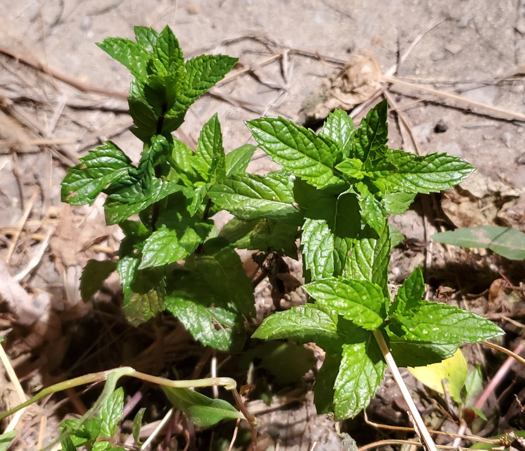
3. Peppermint

Peppermint is wonderful for relieving digestive upset and can soothe irritable bowel syndrome quite fast. It helps relieve stress, nausea, inflammatory conditions, and is known for its incredible ability to get rid of headaches – fast!
Peppermint can be made into a tea, or you can blend it up with medjool dates and some warm water to make a delicious, frothy peppermint drink (or dessert) that you can sip on throughout the day. It is a great addition to almost any chocolate recipe, like chocolate cake, muffins or even cookies!
Peppermint Grows quickly and easily. Just trim off some peppermint from a fresh plant, trim off the bottom leaves, stick into water and off they go! (buy online).
4. Spearmint
Spearmint contains anti-androgenic properties that helps improve individuals’ suffering from polycystic ovarian syndrome (PCOS).
Since spearmint and peppermint possess quite similar properties, the spearmint is also great for treating digestive upsets, as well as nasty headaches.
It can be made into a tea, or you can even add it to fresh ice cream recipes (chocolate mint, anyone?). If you’re anything like me, then you’ll love the taste. It is a tad sweeter than peppermint, and not as much as a shock when you eat it. Just like peppermint, spearmint grows quickly. (buy online).
5. Oregano

Oregano has been found to be superior to prescription antibiotics, working as an effective antibacterial, antiviral, anti-fungal, and antioxidant.
Some test-tube studies have shown that oregano and its components may help kill cancer cells. Oregano grows similar to basil in that in order for it to grow, you should pinch off top maturing leaves to stimulate new growth. (buy online).
This lovely herb can be used in pasta dishes, sauces, stews, soups, or even made into a tea to heal your lungs from symptoms of cough, asthma, bronchitis, and other infections.
6. Lemon Balm

Lemon balm is a wonderful smelling herb that helps repel mosquitoes, heal cold sores and aids digestion. It is also one of the best for repairing a tired and worn out nervous system. It has even been found to help reduce chronic stress and anxiety.
A great way to prepare this herb is plucking off some leaves and steeping them in warm water to make a tea. You can even make a bug spray with the leaves of the plant by soaking 1/2 cup of them in 1 cup of witch hazel for about 1 week. Strain, and pour into a spray bottle.
Follow the directions above to start your lemon balm in a small vase of water. Also, be sure to change the water of this plant once a week to prevent root rot. (buy online).
7. Thyme

Thymol found in thyme, is known to kill cancer cells, as well as lower blood pressure, prevent tooth decay, ease stomach disorders and kill bacteria and fungi. It is also a powerful anti-viral. The essential oil of thyme has been successfully used in keeping mold levels down in the air, particularly when diffused.
Thyme is great in salads, but it really makes an impression in soups. For some reason, I’ve found that thyme gives an almost chicken-like flavor to soup, but without having to use chicken broth (good for people like me who are plant-based!). It also works wonderfully in stews and sauces.
Keep this plant moist by giving it a spritz of water every once in awhile (otherwise it’ll dry out). (buy online).
8. Stevia

This popular natural sweetener is best grown at home to avoid genetically modified organisms and pesticides. Stevia helps reduce the desire for nicotine (to help stop smoking), because there is a link between sugar and nicotine cravings.
Stevia has also been researched for its ability to kill lyme disease co-infections. It does so by targeting the tough biofilms that protect the bacteria from our immune system.
Be sure to keep this plant in a warm area as it does not like the cold. (buy online).
9. Rosemary
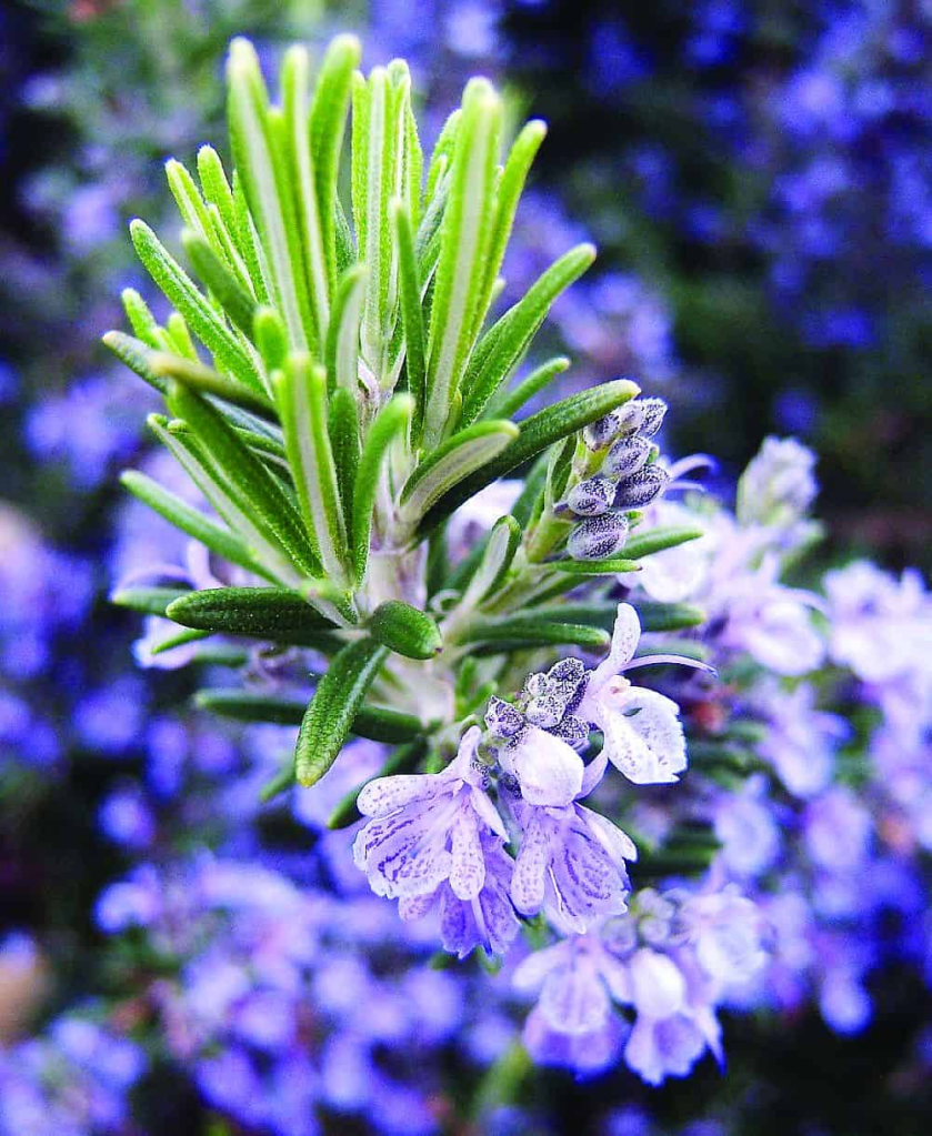
Rosemary has a sharper taste fresh than dried, and is known to improve memory and cognitive function, stimulate hair growth and prevent inflammation.
Rosemary can be enjoyed in soups, stews, and sauces. It is also suggested to add rosemary to any potato dish you add to the oven. Rosemary can help reduce the amount of cancer-causing acrylamide that is created as a by-product of roasting potatoes!
This plant has thick stems, so it takes a while to grow roots. But once it gets going, it takes very well. Rosemary loves warmth, so make sure to place it against a south-facing window. (buy online).
10. Tarragon
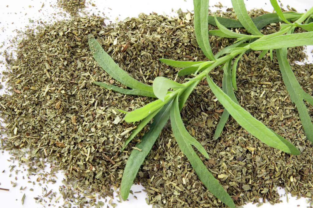
Tarragon is a great herb to help moderate blood sugar and treat metabolic syndrome. It also acts as a strong antibacterial agent (11). Tarragon may also help relieve pain associated with conditions like osteoarthritis.
Tarragon is a very potent herb, so you only have to use it sparingly. It makes a great salad dressing when combined with vinegar and works well with tomatoes and carrots. Try sprinkling some over grilled summer vegetables or a green salad.
Tarragon likes warm, sunny spots to grow in, so make sure they’re next to a south-facing window. (buy online).

Live Love Fruit Company / Crickey Conservation Society 2022.
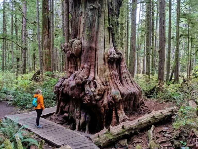
Vancouver Island’s 2000-year old Giant Trees

Vancouver Island is located in the temperate rainforest biome, with the mild climate and high rainfall combining to produce groves of massive old-growth trees. Some of the tallest stretch over 90 meters into the sky, while others measure as much as 20 meters in circumference.
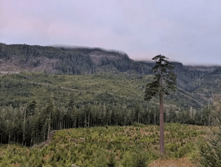
One senses that there is a race between logging companies, who are determined to log and clearcut as permitted by their tree-farm license, and the environmentalists who are desperately trying to find and seek protection for these last pockets of old-growth trees before the chainsaws find and destroy them.

With a huge amount of rainfall and a relatively mild climate, Vancouver Island is the perfect place for trees to grow. And grow they do, with some of the biggest trees in Canada found in the misty valleys of Vancouver Island.
Seeing big trees is a high priority for many visitors to Vancouver Island. And quite rightly, it should be. To admire a living creature much larger and older than any of us is a humbling and sometimes even spiritual experience.
Luckily, there are many opportunities to see and admire big trees on Vancouver Island. This post includes 15 different places across Vancouver Island where it is possible to see incredible old growth trees.

When exploring nature, it is so important to be aware of your impact and make steps to reduce it as much as possible. Doing so helps maintain sensitive forest ecosystems and preserve these magical groves for future generations.
This list of big tree groves on Vancouver Island is not exhaustive. I have, however, chosen to include only big tree groves that have been, at this time, developed for visitors.
This means that all listed groves have basic facilities such as parking and established trails or boardwalks. In addition, almost all (with one exception) of these Vancouver Island big tree groves are located on protected lands.
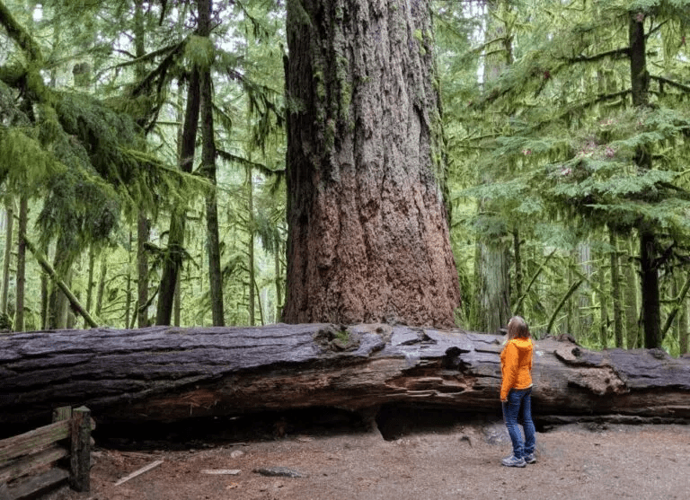
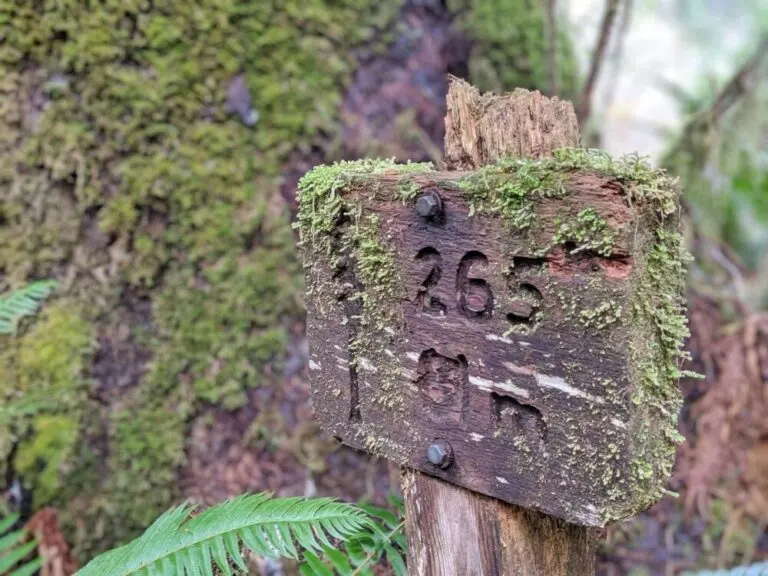
Located in MacMillan Provincial Park, Cathedral Grove is Vancouver Island’s most visited old growth forest. It’s a convenient place to see lots of big trees very quickly. Some of the giant Douglas Fir trees in Cathedral Grove are 2000 years old.
The biggest, found on the short but aptly named ‘Big Tree Trail,’ has a circumference of over 9 metres. A popular stop on the way to Tofino, Cathedral Grove is located right on Highway 4, between Port Alberni and Coombs.
Cathedral Grove isn’t the only place to see big trees on the way to Tofino. A short walk on the Giant Cedar Trail will reveal a number of huge cedar trees, with the most magnificent being found within 500m of the road.
The Giant Cedar Trail itself is a little overgrown and not as manicured as those found in Cathedral Grove, but you’re likely to have the beautiful cedar trees here all to yourself.
The Giant Cedar Trail is one of my most recent discoveries on Vancouver Island, something I’m a little embarrassed about since it is right on Highway 4! It is well signed too, just look for the Canoe Creek / Giant Cedar Trail signs about 19km after the Taylor River Rest Area when approaching from the east.
The Ancient Cedars Loop is part of Ucluelet’s wonderful Wild Pacific Trail. This section takes only 15-20 minutes to walk and is easily accessible straight from the highway.

For such low effort, the reward is surprisingly high with large cedar trees appearing next to the trail almost immediately. Some are over 800 years old.
Being so close to the ocean, the trees found along the Ancient Cedars Loop have had to regularly withstand extreme weather conditions including gale force winds and lightning storms.
Be sure to extend a little further along the Wild Pacific Trail to see the spectacular coastal scenery that characterizes this area.

The Long Beach Unit of Pacific Rim National Park showcases Vancouver Island’s coastal scenery in its many forms, from windswept sandy beaches and rocky coves to bogs and temperate rain forest.
One of Vancouver Island’s most recently developed big tree groves, Avatar Grove offers two short trails through an old growth forest filled with cedars and firs.
The northern route is home to “Canada’s Gnarliest Tree,” a cedar with a gargantuan burl (knotty growth). The southern boardwalk loop trail also has its share of gnarly trees, with my favorite being the one pictured below.
Avatar Grove is located about 10km north of Port Renfrew, with the last 6km on unsealed industrial roads.
f you have a vehicle with decent clearance and good tires (AWD or 4X4 would be beneficial), I’d recommend also visiting Big Lonely Doug, Canada’s second tallest Douglas Fir. It sits in a clear cut just fifteen minutes from Avatar Grove.
Drive north on Gordon River Road and then take a left on Edinburgh Main. The road is good for the most part but there is a steep hill close to Big Lonely Doug that could be challenging for smaller vehicles.
Not only can you see big trees on Vancouver Island, but it is also possible to camp under them too! The following campgrounds all feature large trees within their boundaries, making it possible to both sleep under the stars and a canopy of old growth.
Set into an old growth Douglas Fir forest, Rathtrevor Provincial Park hosts one of the most popular campgrounds on Vancouver Island. The popularity is well deserved, with a 2km long scenic beach to explore in addition to the impressive forest.
Reservations are required to get one of the 250 vehicle accessible or 25 walk-in camp spots in summer. Be sure to book early! There is also a day use area.
Off Track Travel / Crickey Nature Conservation Society 2022.
Cheeky Otters are thriving in Singapore

On a grassy strip along the highway, a blur of brown fur moves quickly, a small head popping up every so often to check for danger. Like many urban species, the aquatic mammals are changing their behavior to fit into their new home, research shows.
It’s a family of seven otters, likely on their way to their den at the Singapore Botanic Gardens. Commuters sitting in evening traffic appear oblivious, likely already accustomed to seeing the charismatic mammals traipsing about this Southeast Asian metropolis of 5.7 million.

It’s a far cry from 50 years ago, when Singapore’s rivers were choked with rotting animal carcasses, garbage, and sewage. Smooth-coated otters, native to the area, had disappeared and wherein danger of being locally extinct.
In 1977, the Singaporean government launched its Clean River Campaign, and in 1998, otters began to return to the tropical island on their own.
Now at least 90 otters, part of 10 thriving families, live within the island-state, and their population is growing, thanks to rich food sources—such as koi ponds—and lack of predators.

The 20-pound creatures have also adapted well to urban spaces, denning in concrete bridges and basking on patches of sand between slabs of pavement. (In one humorous incident, otters climbed up a metal maintenance ladder to exit a canal.)
But the rise of the urban otter has caused some conflicts with people.
Homeowners in the gated-community enclave on the island of Sentosa reported in 2015 that their koi carp ponds had been emptied by otters, and one hotel in the same area lost 85,000 Singaporean dollars’ worth of ornamental fish over eight months, according to local news reports.

In 2017, news outlets reported that an otter bit a five-year-old girl at a nature park, the Gardens by the Bay. Despite these run-ins, the Singaporeans are generally fond of their cheeky neighbors.
When asked to vote for a mascot that would represent Singapore in its 2016 National Day celebrations, citizens voted wholeheartedly for the otter.
For National University of Singapore biologist Sivasothi N, the arrival of the Singapore otter—and its popularity among residents—is a welcome development.

When the animals first reappeared in Singapore’s waterways, they were so unknown to most that people thought that they could be beavers or seals, says Sivasothi, who launched the website OtterWatch to help educate locals about these new inhabitants.
In the early 1990’s, he recalls traveling to Penang in Malaysia to study the species, walking through the mangroves for hours, hoping to spot a single otter.
Now, to do his research all he has to do is step outside his house to see the sleek, playful creatures that are doing just swimmingly in Singapore.
National Geographic / Crickey Conservation Society 2022.
Himalayan Pink Salt Health Benefits

Himalayan pink salt is a pink-hued variety of salt that is sourced near the Himalaya mountains of South Asia. Himalayan salt is believed by many to be a healthier alternative to common table salt, or sodium chloride. Though mined like rock salt, Himalayan pink salt is technically a sea salt.
Salt is an essential nutrient required for many biological processes that has seasoned our dinners for thousands of years. However, its use has a few notable disadvantages for human health.

Consuming too much salt may cause high blood pressure, stroke, and heart disease, which is why it should be eaten in moderation. For this reason, Himalayan pink salt has emerged as an alternative to regular salt, purportedly because it is less stressful for the body to consume.
A number of health benefits are attributed to Himalayan pink salt, but is there any real science behind these claims? Sodium levels in salt can vary. Himalayan pink salt contains less sodium per serving than ordinary table salt.
Table salt contains 2360 milligrams of sodium per teaspoon, whereas a teaspoon of Himalayan pink salt contains 1680 milligrams of sodium — a reduction of about one-third. Himalayan pink salt can contain trace amounts of minerals that table salt does not.
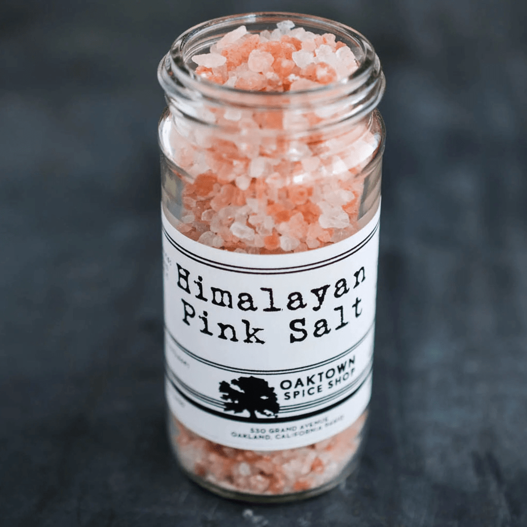
This can vary depending on where the Himalayan pink salt is sourced. More importantly, some samples of Himalayan pink salt have been found to contain potentially toxic elements like arsenic, mercury, and lead.
While Himalayan pink salt can contain minerals that table salt does not, these minerals exist only in very small quantities. Scientists don’t believe that the amount of additional minerals in Himalayan pink salt is great enough to make a significant difference in your diet.

Many believe that salt therapy, which involves the inhalation of air infused with salt, is beneficial for respiratory conditions like chronic obstructive pulmonary disease, or COPD.
Although much more research on this point is needed, scientists have found statistically significant improvements in questionnaires given to respondents with COPD who used a dry salt inhaler.
Webmd.com / Crickey Conservation Society 2022.
Zakito Bouw- en Milieu Vergunning Jachthaven indienen LOB Verzoek

Op 18 Januari 2022, werd door de Natuur Stichting van Crickey Amigu di Natura een LOB verzoek ingediend om inzage te krijgen op de zogenaamde bouwvergunning voor een zwaar vervuilende Jachthaven in wereldwijde beschermd mangrove gebied nabij de KAE te Otranbanda.
Buurtbewoners van Piscadera zijn bij monde van Jeanette Jansen ook in de pen gekropen om publieke duidelijkheid te vragen over de reeds gestarte bouwwerkzaamheden die uitgevoerd worden in het project naast Royal Palm resort, genaamd Highrise Zakito & Marina?
De ontwikkelaars wensen daar 120 exclusieve apartementen (6 to 9 verdiepingen hoog) en een jachthaven te bouwen. De omwonenden zijn van mening dat het project hinder veroorzaakt aan de direkte omgeving, en bovendien 54 koraal soorten bedreigd bij het doorbreken van de dijk.
Verder voldoet de bouw niet aan het Eilandelijk Ontwikkelings Plan (EOP 1997) en past deze niet in het landschap qua omvang en bouwhoogte. Het gaat om het project dat valt onder de verfraaing van Zakito waarvoor de corrupte regering Rhuggenaath in maart 2020 het terrein in erfpacht gaf.
Ook werd er een Letter of Intend getekend met betrekking tot de mangrove lagune naast het resort. Er is een investeringsbedrag van fl.65 miljoen mee gemoeid, wat in 2021 uit de doeken werd gedaan.
Werd er wel een definitieve (bouw en milieu) vergunning afgegeven, zo ja welke aspecten werden er dan geevalueerd, voorafgaand aan het verstrekken van de vergunning. Verzoeken aan het VVRP om duidelijkheid daaromtrent blijven onbeantwoord.
Evenmin zijn de bewoners van Piscadera uitgenodigd voor een informatie bijeenkomst door de duistere project ontwikkelaar en/of de overheid. Hierdoor blijven er veel vraagtekens rond dit eco-terrorisme project.
Bij de reeds gestarte bouwwerkzaamheden worden mangroves en bomen vernield, die van essentieel belang zijn voor het ecosysteem, waardoor de flora en fauna in gevaar komen.

Eerder werd door de PAR/MAN regering op Curacao onrechtmatig een bouw vergunning afgestaan aan Corendon, die middenin een mangrove bos het grootste hotel op het eiland mag bouwen. Op de koop toe werd de financiering hiervoor, met pensioen spaargeld van de lokale bevolking, door APC verschaft.

Ook mag de familie Smeets zonder geldige mijn-vergunning de tafelberg verder afgraven tot dat er geen fosfaat meer te winnen en/of over is?
Inmiddels werd deze grondstof aangeworven om de bouw van 25.000 nederzettingen te verschaffen, waarbij zwaar plunderende massa toeristen fabrieken de hoofdrol in dit herkolonisatie proces vervullen.
EOP Wetgeving 1997 / Curacao Conservation Society
