
10 Herbs you can Grow Indoors In Water All Year Long

Winter usually marks the end of fresh local produce (especially if you live in the Northern hemisphere). But what if you could grow some plants indoors without the hassle of mud and planters?
Well, fortunately for you, the answer to that question is yes. There are over 10 herbs you can grow indoors all winter long, and even without mud (how cool is that?). As a bonus, they make as an attractive addition to any windowsill or desk.

Herbs that root in water and grow throughout winter are perennial herbs. Annual herbs typically only grow one season, produce seeds, and then die (1). Perennials will keep coming back, as long as you pinch off the older leaves as they grow to full size.
Growing herbs indoors isn’t as difficult as when you’re trying to grow vegetables or fruit indoors.
Unless otherwise noted, full plants can be rooted from whole leaves with the base intact or from trimmed stems. You can start with herb plants from your garden, or even perennial herbs from the grocery store.

Make sure the stems are 6 inches long, and remove the leaves from the bottom 4 inches of the stems. If using herbs from the grocery store, cut the very bottom of each stem to allow them to absorb more water.
Place the herb stems in glass jars (opaque is best) filled with water (not distilled) and place them in a spot where they get bright direct light for at least 6 hours each day.
Clip each leaf as it grows to full size to encourage the stem to produce more leaves at the top. This will also allow the stem to grow for months at a time.

Whether you want to start a kitchen herb garden as a hobby, or simply want to save money, there are plenty of herbs that you can start with. Fresh herbs make everything taste better. From fresh salads to soups and stews, herbs will bring everything to a whole other level.
There is nothing better than an attractive row of fresh herb vases along the windowsill (especially in the dead of winter). Some of the easiest and most popular herbs grown in water are:
1. Basil

Basil makes a great pain-relieving supplement, moderates blood sugar levels, and is a potent antibiotic, antiviral and anti-fungal. It is great for relieving coughs, and symptoms of bronchitis.
This popular Italian herb can be used on pizza, in pasta sauces, salads and even pesto! While basil does improve the taste of your tomatoes when companion planted, it doesn’t mean you can’t also have it on your windows.
Basil is very easy to grow in water, when following the basic instructions above. You can use any variety of basil, too. My favourite is large leaf Italian sweet basil. (buy online).
2. Culinary Sage

Sage is great at inhibiting the inflammatory response in the body (3). For this reason, sage can help remediate symptoms that come with ailments like arthritis, bronchial asthma and atherosclerosis.
Take a few sprigs in the spring (or end of season) from an outdoor plant and place in shallow water. It will quickly sprout roots! Sage does not like to be crowded, and likes plenty of air space for prevention of mildew. Leaves should not touch the water.
You can add fresh sage to your salads, in gravies and sauces, or you can steep it fresh in a tea to help soothe irritated lungs. (buy online).
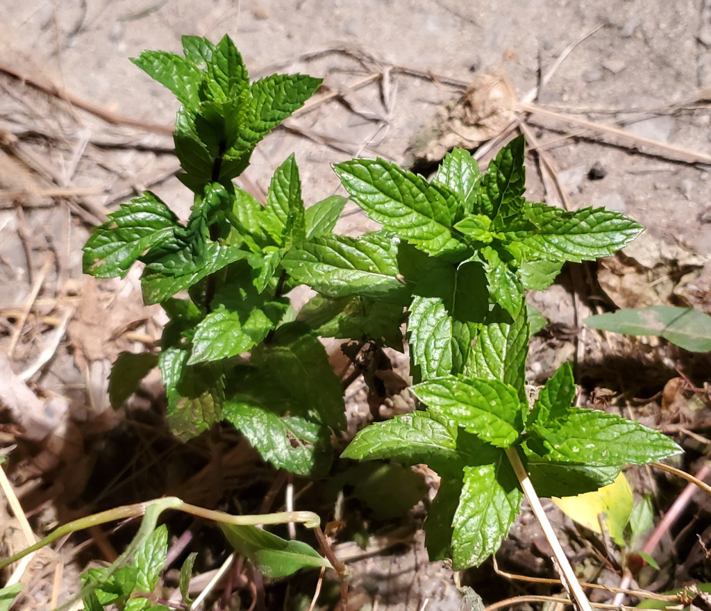
3. Peppermint

Peppermint is wonderful for relieving digestive upset and can soothe irritable bowel syndrome quite fast. It helps relieve stress, nausea, inflammatory conditions, and is known for its incredible ability to get rid of headaches – fast!
Peppermint can be made into a tea, or you can blend it up with medjool dates and some warm water to make a delicious, frothy peppermint drink (or dessert) that you can sip on throughout the day. It is a great addition to almost any chocolate recipe, like chocolate cake, muffins or even cookies!
Peppermint Grows quickly and easily. Just trim off some peppermint from a fresh plant, trim off the bottom leaves, stick into water and off they go! (buy online).
4. Spearmint
Spearmint contains anti-androgenic properties that helps improve individuals’ suffering from polycystic ovarian syndrome (PCOS).
Since spearmint and peppermint possess quite similar properties, the spearmint is also great for treating digestive upsets, as well as nasty headaches.
It can be made into a tea, or you can even add it to fresh ice cream recipes (chocolate mint, anyone?). If you’re anything like me, then you’ll love the taste. It is a tad sweeter than peppermint, and not as much as a shock when you eat it. Just like peppermint, spearmint grows quickly. (buy online).
5. Oregano

Oregano has been found to be superior to prescription antibiotics, working as an effective antibacterial, antiviral, anti-fungal, and antioxidant.
Some test-tube studies have shown that oregano and its components may help kill cancer cells. Oregano grows similar to basil in that in order for it to grow, you should pinch off top maturing leaves to stimulate new growth. (buy online).
This lovely herb can be used in pasta dishes, sauces, stews, soups, or even made into a tea to heal your lungs from symptoms of cough, asthma, bronchitis, and other infections.
6. Lemon Balm

Lemon balm is a wonderful smelling herb that helps repel mosquitoes, heal cold sores and aids digestion. It is also one of the best for repairing a tired and worn out nervous system. It has even been found to help reduce chronic stress and anxiety.
A great way to prepare this herb is plucking off some leaves and steeping them in warm water to make a tea. You can even make a bug spray with the leaves of the plant by soaking 1/2 cup of them in 1 cup of witch hazel for about 1 week. Strain, and pour into a spray bottle.
Follow the directions above to start your lemon balm in a small vase of water. Also, be sure to change the water of this plant once a week to prevent root rot. (buy online).
7. Thyme

Thymol found in thyme, is known to kill cancer cells, as well as lower blood pressure, prevent tooth decay, ease stomach disorders and kill bacteria and fungi. It is also a powerful anti-viral. The essential oil of thyme has been successfully used in keeping mold levels down in the air, particularly when diffused.
Thyme is great in salads, but it really makes an impression in soups. For some reason, I’ve found that thyme gives an almost chicken-like flavor to soup, but without having to use chicken broth (good for people like me who are plant-based!). It also works wonderfully in stews and sauces.
Keep this plant moist by giving it a spritz of water every once in awhile (otherwise it’ll dry out). (buy online).
8. Stevia

This popular natural sweetener is best grown at home to avoid genetically modified organisms and pesticides. Stevia helps reduce the desire for nicotine (to help stop smoking), because there is a link between sugar and nicotine cravings.
Stevia has also been researched for its ability to kill lyme disease co-infections. It does so by targeting the tough biofilms that protect the bacteria from our immune system.
Be sure to keep this plant in a warm area as it does not like the cold. (buy online).
9. Rosemary
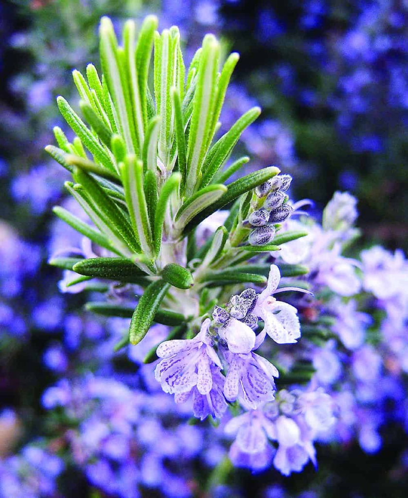
Rosemary has a sharper taste fresh than dried, and is known to improve memory and cognitive function, stimulate hair growth and prevent inflammation.
Rosemary can be enjoyed in soups, stews, and sauces. It is also suggested to add rosemary to any potato dish you add to the oven. Rosemary can help reduce the amount of cancer-causing acrylamide that is created as a by-product of roasting potatoes!
This plant has thick stems, so it takes a while to grow roots. But once it gets going, it takes very well. Rosemary loves warmth, so make sure to place it against a south-facing window. (buy online).
10. Tarragon

Tarragon is a great herb to help moderate blood sugar and treat metabolic syndrome. It also acts as a strong antibacterial agent (11). Tarragon may also help relieve pain associated with conditions like osteoarthritis.
Tarragon is a very potent herb, so you only have to use it sparingly. It makes a great salad dressing when combined with vinegar and works well with tomatoes and carrots. Try sprinkling some over grilled summer vegetables or a green salad.
Tarragon likes warm, sunny spots to grow in, so make sure they’re next to a south-facing window. (buy online).

Live Love Fruit Company / Crickey Conservation Society 2022.
Vancouver Island’s 2000-year old Giant Trees

Vancouver Island is located in the temperate rainforest biome, with the mild climate and high rainfall combining to produce groves of massive old-growth trees. Some of the tallest stretch over 90 meters into the sky, while others measure as much as 20 meters in circumference.
One senses that there is a race between logging companies, who are determined to log and clearcut as permitted by their tree-farm license, and the environmentalists who are desperately trying to find and seek protection for these last pockets of old-growth trees before the chainsaws find and destroy them.

With a huge amount of rainfall and a relatively mild climate, Vancouver Island is the perfect place for trees to grow. And grow they do, with some of the biggest trees in Canada found in the misty valleys of Vancouver Island.
Seeing big trees is a high priority for many visitors to Vancouver Island. And quite rightly, it should be. To admire a living creature much larger and older than any of us is a humbling and sometimes even spiritual experience.
Luckily, there are many opportunities to see and admire big trees on Vancouver Island. This post includes 15 different places across Vancouver Island where it is possible to see incredible old growth trees.

When exploring nature, it is so important to be aware of your impact and make steps to reduce it as much as possible. Doing so helps maintain sensitive forest ecosystems and preserve these magical groves for future generations.
This list of big tree groves on Vancouver Island is not exhaustive. I have, however, chosen to include only big tree groves that have been, at this time, developed for visitors.
This means that all listed groves have basic facilities such as parking and established trails or boardwalks. In addition, almost all (with one exception) of these Vancouver Island big tree groves are located on protected lands.
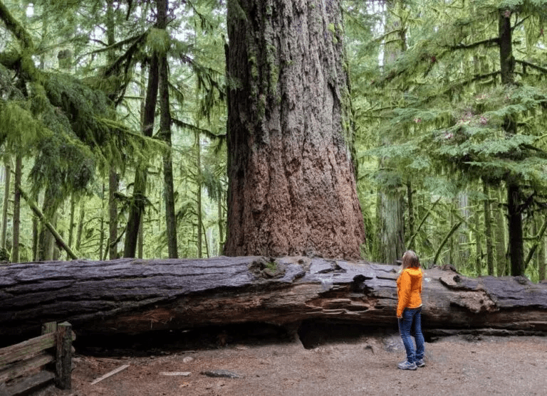
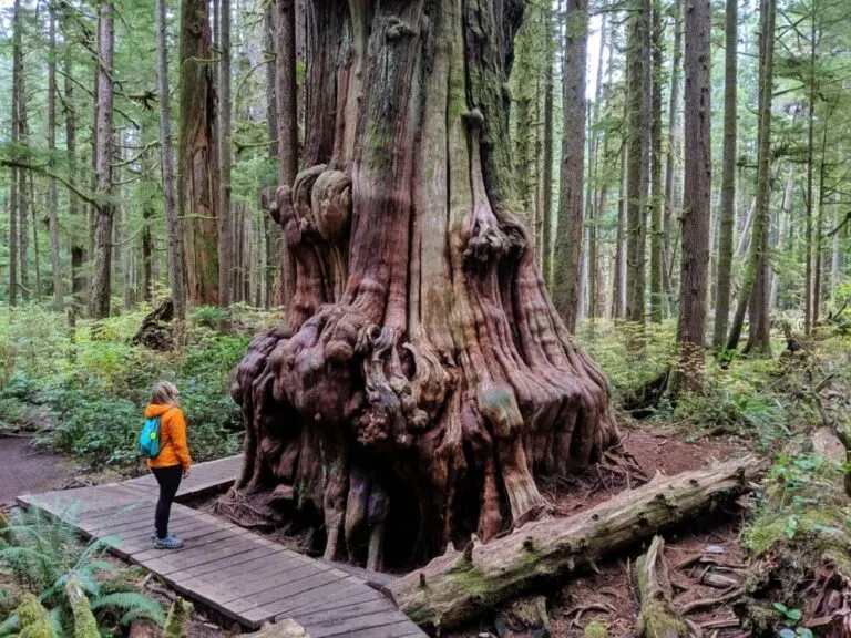
Located in MacMillan Provincial Park, Cathedral Grove is Vancouver Island’s most visited old growth forest. It’s a convenient place to see lots of big trees very quickly. Some of the giant Douglas Fir trees in Cathedral Grove are 2000 years old.
The biggest, found on the short but aptly named ‘Big Tree Trail,’ has a circumference of over 9 metres. A popular stop on the way to Tofino, Cathedral Grove is located right on Highway 4, between Port Alberni and Coombs.
Cathedral Grove isn’t the only place to see big trees on the way to Tofino. A short walk on the Giant Cedar Trail will reveal a number of huge cedar trees, with the most magnificent being found within 500m of the road.
The Giant Cedar Trail itself is a little overgrown and not as manicured as those found in Cathedral Grove, but you’re likely to have the beautiful cedar trees here all to yourself.
The Giant Cedar Trail is one of my most recent discoveries on Vancouver Island, something I’m a little embarrassed about since it is right on Highway 4! It is well signed too, just look for the Canoe Creek / Giant Cedar Trail signs about 19km after the Taylor River Rest Area when approaching from the east.
The Ancient Cedars Loop is part of Ucluelet’s wonderful Wild Pacific Trail. This section takes only 15-20 minutes to walk and is easily accessible straight from the highway.

For such low effort, the reward is surprisingly high with large cedar trees appearing next to the trail almost immediately. Some are over 800 years old.
Being so close to the ocean, the trees found along the Ancient Cedars Loop have had to regularly withstand extreme weather conditions including gale force winds and lightning storms.
Be sure to extend a little further along the Wild Pacific Trail to see the spectacular coastal scenery that characterizes this area.

The Long Beach Unit of Pacific Rim National Park showcases Vancouver Island’s coastal scenery in its many forms, from windswept sandy beaches and rocky coves to bogs and temperate rain forest.
One of Vancouver Island’s most recently developed big tree groves, Avatar Grove offers two short trails through an old growth forest filled with cedars and firs.
The northern route is home to “Canada’s Gnarliest Tree,” a cedar with a gargantuan burl (knotty growth). The southern boardwalk loop trail also has its share of gnarly trees, with my favorite being the one pictured below.
Avatar Grove is located about 10km north of Port Renfrew, with the last 6km on unsealed industrial roads.
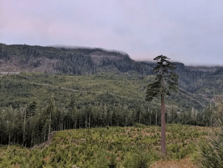
f you have a vehicle with decent clearance and good tires (AWD or 4X4 would be beneficial), I’d recommend also visiting Big Lonely Doug, Canada’s second tallest Douglas Fir. It sits in a clear cut just fifteen minutes from Avatar Grove.
Drive north on Gordon River Road and then take a left on Edinburgh Main. The road is good for the most part but there is a steep hill close to Big Lonely Doug that could be challenging for smaller vehicles.
Not only can you see big trees on Vancouver Island, but it is also possible to camp under them too! The following campgrounds all feature large trees within their boundaries, making it possible to both sleep under the stars and a canopy of old growth.
Set into an old growth Douglas Fir forest, Rathtrevor Provincial Park hosts one of the most popular campgrounds on Vancouver Island. The popularity is well deserved, with a 2km long scenic beach to explore in addition to the impressive forest.
Reservations are required to get one of the 250 vehicle accessible or 25 walk-in camp spots in summer. Be sure to book early! There is also a day use area.
Off Track Travel / Crickey Nature Conservation Society 2022.
Cheeky Otters are thriving in Singapore

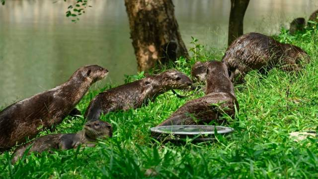
On a grassy strip along the highway, a blur of brown fur moves quickly, a small head popping up every so often to check for danger. Like many urban species, the aquatic mammals are changing their behavior to fit into their new home, research shows.
It’s a family of seven otters, likely on their way to their den at the Singapore Botanic Gardens. Commuters sitting in evening traffic appear oblivious, likely already accustomed to seeing the charismatic mammals traipsing about this Southeast Asian metropolis of 5.7 million.

It’s a far cry from 50 years ago, when Singapore’s rivers were choked with rotting animal carcasses, garbage, and sewage. Smooth-coated otters, native to the area, had disappeared and wherein danger of being locally extinct.
In 1977, the Singaporean government launched its Clean River Campaign, and in 1998, otters began to return to the tropical island on their own.
Now at least 90 otters, part of 10 thriving families, live within the island-state, and their population is growing, thanks to rich food sources—such as koi ponds—and lack of predators.

The 20-pound creatures have also adapted well to urban spaces, denning in concrete bridges and basking on patches of sand between slabs of pavement. (In one humorous incident, otters climbed up a metal maintenance ladder to exit a canal.)
But the rise of the urban otter has caused some conflicts with people.
Homeowners in the gated-community enclave on the island of Sentosa reported in 2015 that their koi carp ponds had been emptied by otters, and one hotel in the same area lost 85,000 Singaporean dollars’ worth of ornamental fish over eight months, according to local news reports.
In 2017, news outlets reported that an otter bit a five-year-old girl at a nature park, the Gardens by the Bay. Despite these run-ins, the Singaporeans are generally fond of their cheeky neighbors.
When asked to vote for a mascot that would represent Singapore in its 2016 National Day celebrations, citizens voted wholeheartedly for the otter.
For National University of Singapore biologist Sivasothi N, the arrival of the Singapore otter—and its popularity among residents—is a welcome development.

When the animals first reappeared in Singapore’s waterways, they were so unknown to most that people thought that they could be beavers or seals, says Sivasothi, who launched the website OtterWatch to help educate locals about these new inhabitants.
In the early 1990’s, he recalls traveling to Penang in Malaysia to study the species, walking through the mangroves for hours, hoping to spot a single otter.
Now, to do his research all he has to do is step outside his house to see the sleek, playful creatures that are doing just swimmingly in Singapore.
National Geographic / Crickey Conservation Society 2022.
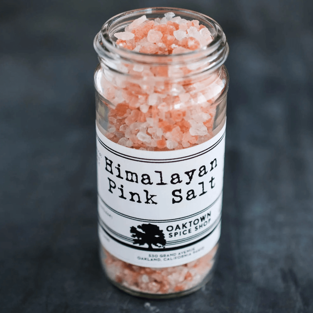
Himalayan Pink Salt Health Benefits

Himalayan pink salt is a pink-hued variety of salt that is sourced near the Himalaya mountains of South Asia. Himalayan salt is believed by many to be a healthier alternative to common table salt, or sodium chloride. Though mined like rock salt, Himalayan pink salt is technically a sea salt.
Salt is an essential nutrient required for many biological processes that has seasoned our dinners for thousands of years. However, its use has a few notable disadvantages for human health.
Consuming too much salt may cause high blood pressure, stroke, and heart disease, which is why it should be eaten in moderation. For this reason, Himalayan pink salt has emerged as an alternative to regular salt, purportedly because it is less stressful for the body to consume.
A number of health benefits are attributed to Himalayan pink salt, but is there any real science behind these claims? Sodium levels in salt can vary. Himalayan pink salt contains less sodium per serving than ordinary table salt.
Table salt contains 2360 milligrams of sodium per teaspoon, whereas a teaspoon of Himalayan pink salt contains 1680 milligrams of sodium — a reduction of about one-third. Himalayan pink salt can contain trace amounts of minerals that table salt does not.
This can vary depending on where the Himalayan pink salt is sourced. More importantly, some samples of Himalayan pink salt have been found to contain potentially toxic elements like arsenic, mercury, and lead.
While Himalayan pink salt can contain minerals that table salt does not, these minerals exist only in very small quantities. Scientists don’t believe that the amount of additional minerals in Himalayan pink salt is great enough to make a significant difference in your diet.

Many believe that salt therapy, which involves the inhalation of air infused with salt, is beneficial for respiratory conditions like chronic obstructive pulmonary disease, or COPD.
Although much more research on this point is needed, scientists have found statistically significant improvements in questionnaires given to respondents with COPD who used a dry salt inhaler.
Webmd.com / Crickey Conservation Society 2022.
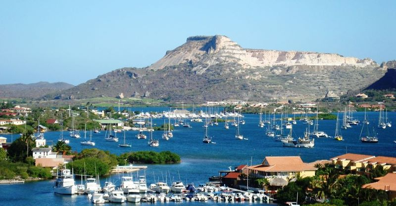
Zakito Bouw- en Milieu Vergunning Jachthaven indienen LOB Verzoek

Op 18 Januari 2022, werd door de Natuur Stichting van Crickey Amigu di Natura een LOB verzoek ingediend om inzage te krijgen op de zogenaamde bouwvergunning voor een zwaar vervuilende Jachthaven in wereldwijde beschermd mangrove gebied nabij de KAE te Otranbanda.
Buurtbewoners van Piscadera zijn bij monde van Jeanette Jansen ook in de pen gekropen om publieke duidelijkheid te vragen over de reeds gestarte bouwwerkzaamheden die uitgevoerd worden in het project naast Royal Palm resort, genaamd Highrise Zakito & Marina?
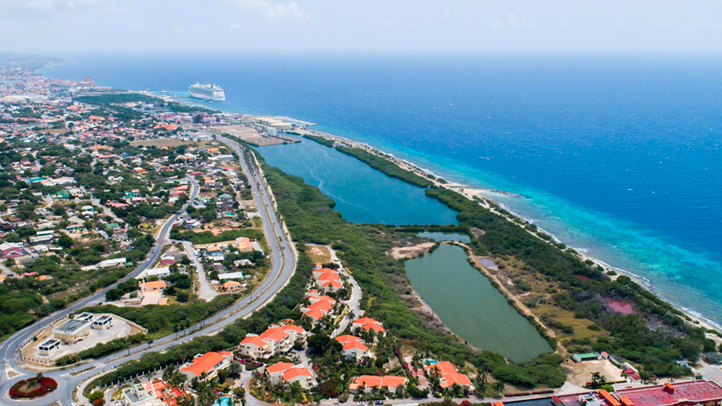
De ontwikkelaars wensen daar 120 exclusieve apartementen (6 to 9 verdiepingen hoog) en een jachthaven te bouwen. De omwonenden zijn van mening dat het project hinder veroorzaakt aan de direkte omgeving, en bovendien 54 koraal soorten bedreigd bij het doorbreken van de dijk.
Verder voldoet de bouw niet aan het Eilandelijk Ontwikkelings Plan (EOP 1997) en past deze niet in het landschap qua omvang en bouwhoogte. Het gaat om het project dat valt onder de verfraaing van Zakito waarvoor de corrupte regering Rhuggenaath in maart 2020 het terrein in erfpacht gaf.
Ook werd er een Letter of Intend getekend met betrekking tot de mangrove lagune naast het resort. Er is een investeringsbedrag van fl.65 miljoen mee gemoeid, wat in 2021 uit de doeken werd gedaan.
Werd er wel een definitieve (bouw en milieu) vergunning afgegeven, zo ja welke aspecten werden er dan geevalueerd, voorafgaand aan het verstrekken van de vergunning. Verzoeken aan het VVRP om duidelijkheid daaromtrent blijven onbeantwoord.
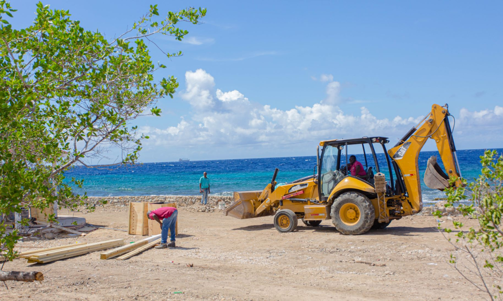
Evenmin zijn de bewoners van Piscadera uitgenodigd voor een informatie bijeenkomst door de duistere project ontwikkelaar en/of de overheid. Hierdoor blijven er veel vraagtekens rond dit eco-terrorisme project.
Bij de reeds gestarte bouwwerkzaamheden worden mangroves en bomen vernield, die van essentieel belang zijn voor het ecosysteem, waardoor de flora en fauna in gevaar komen.
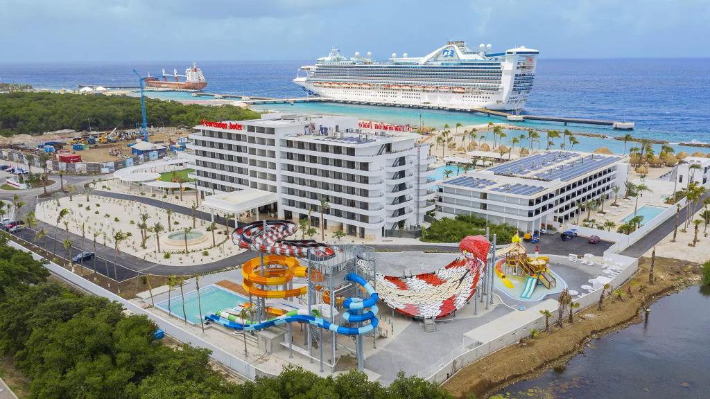
Eerder werd door de PAR/MAN regering op Curacao onrechtmatig een bouw vergunning afgestaan aan Corendon, die middenin een mangrove bos het grootste hotel op het eiland mag bouwen. Op de koop toe werd de financiering hiervoor, met pensioen spaargeld van de lokale bevolking, door APC verschaft.
Ook mag de familie Smeets zonder geldige mijn-vergunning de tafelberg verder afgraven tot dat er geen fosfaat meer te winnen en/of over is?
Inmiddels werd deze grondstof aangeworven om de bouw van 25.000 nederzettingen te verschaffen, waarbij zwaar plunderende massa toeristen fabrieken de hoofdrol in dit herkolonisatie proces vervullen.
EOP Wetgeving 1997 / Curacao Conservation Society
Giant African Snail

Giant African snail (GAS), giant African land snail, kalutara snail was first introduced to Hawaii in 1936; and later introduced to the continental USA in 1966.
Imported as pets and for educational purposes; may also arrive accidentally in cargo. Agricultural and garden pest; attacks and feeds on hundreds of different plant species.

Florida Agriculture Commissioner Nikki Fried and the Florida Department of Agriculture and Consumer Services (FDACS) Division of Plant Industry (DPI), along with the U.S. Department of Agriculture (USDA), announced the eradication of the giant African land snail (GALS) from Broward and Miami-Dade counties.
This eradication announcement marks only the second time this pest has been eradicated in the world, both in South Florida.
For the past 11 years, the FDACS Division of Plant Industry has worked toward eradication through multiple rounds of visual surveys and inspections, K-9 detector dog surveys and inspections, manual collection and treatment programs.

In total, 168,538 snails were collected from 32 core population areas comprised of thousands of properties. The giant African land snail is a highly invasive agricultural pest, known to feed on over 500 varieties of plants.
They also pose a risk to humans and animals by carrying rat lung worm, a parasite that can cause meningitis in humans. Both the USDA and DPI will continue to remain vigilant in their commitments to safeguard American agriculture through surveys, early detection, and rapid response.

Meningitis is an infection and inflammation of the fluid and membranes surrounding the brain and spinal cord. These membranes are called meninges. The inflammation from meningitis typically triggers symptoms such as headache, fever and a stiff neck.
Most cases of meningitis in the USA are caused by a viral infection. But bacteria, parasites and fungi also can cause it. Some cases of meningitis improve without treatment in a few weeks. Others can cause death and require emergency antibiotic treatment.Seek immediate medical care if you suspect that you or someone in your family has meningitis. Early treatment of bacterial meningitis can prevent serious complications. Early meningitis symptoms may be similar to the flu. Symptoms may develop over several hours or over a few days.
USDA National Invasive Species Information Center / Crickey Conservation Society 2022.
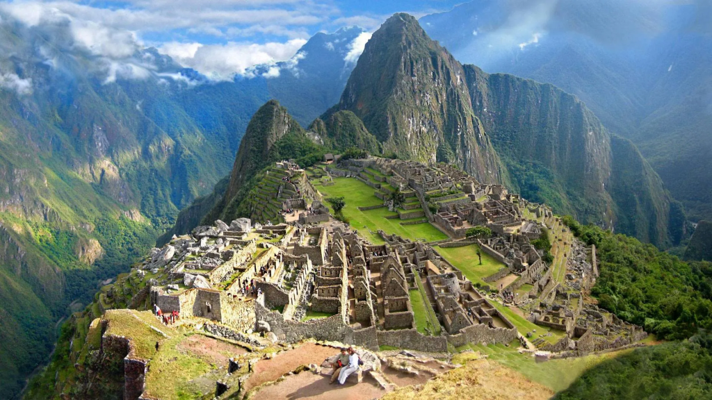
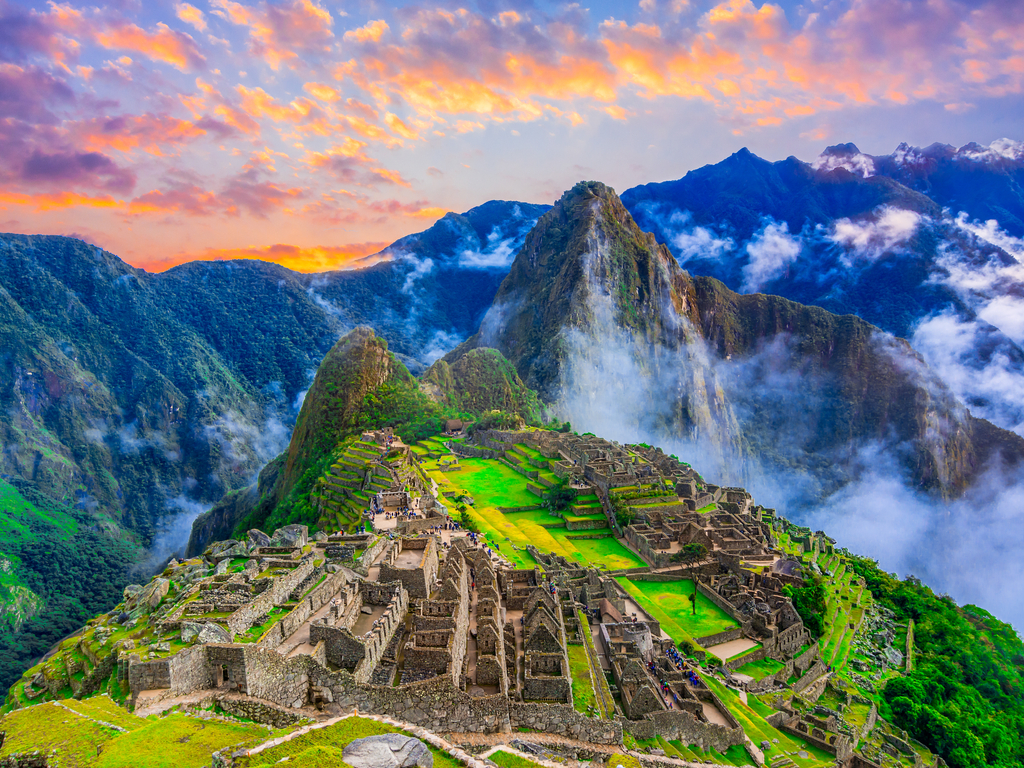
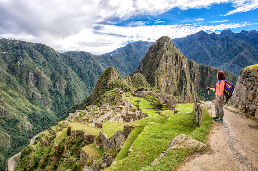
The Best Place in the Andes Mountains to visit in Peru is Machu Picchu

South America has countless landscapes and tourist destinations to look at, among them the ruins of Lost City or Machu Picchu, for which there is the eternal debate about which one is better to pay a visit.
And although there is no one better than the other, as there is no comparison between them, you can always choose the one that best suits your travel plan.
The Lost City and Machu Picchu are more than 2000 km apart and are located in two completely different countries, so you may not plan to visit both during the same trip.
If you are planning to travel to Peru, Machu Picchu will have to be your mandatory stop. And if you are planning to travel to Colombia, your compulsory visit will be to Lost City.
Although there are several ways to get to both places, it is true that the options for getting to Machu Picchu are more original and varied. As for how to get to Lost City, the options are a little more limited as only guided tours are available.

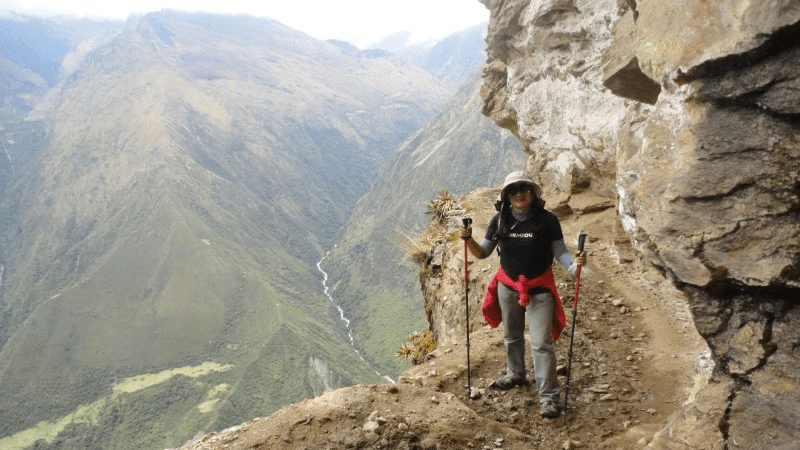
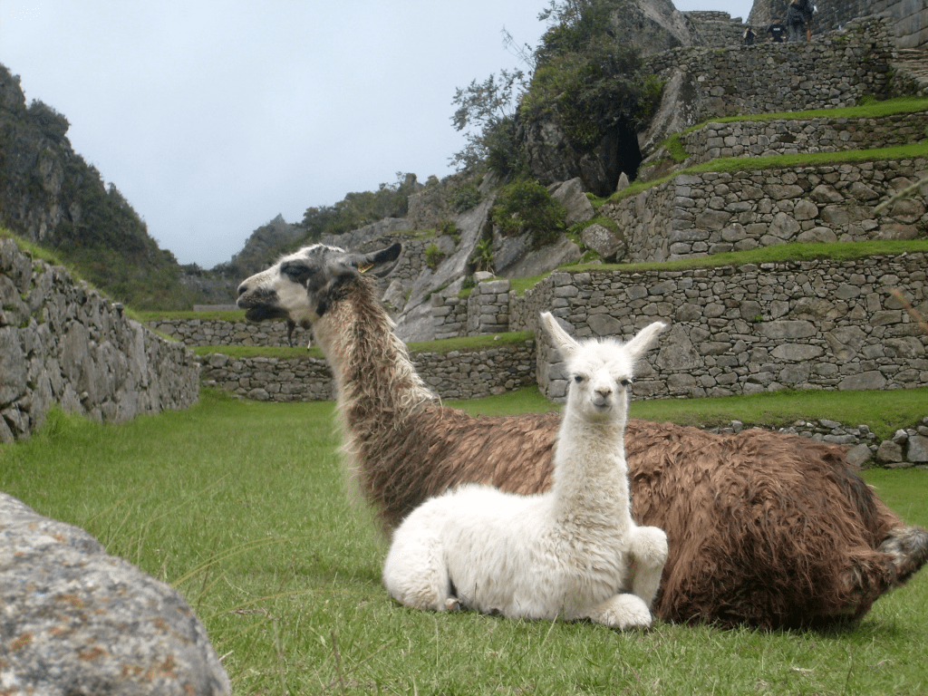
Llamas seem to graze everywhere in Peru’s mountains, but none of them are quite as memorable as the herd at Choquequirao, a sprawling pre-Columbian archaeological complex in the southern Andes.
Here, white rocks embedded in the walls of gray schist stone terraces depict two dozen llamas, impressing tourists and archaeologists alike.
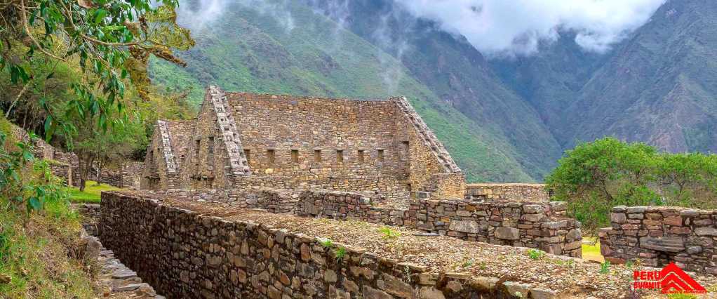
Choquequirao, or Choque to locals, is a cousin to the more visited Machu Picchu. Built by the Inca, it includes ceremonial halls, chambers that once held mummies, intricate farming terraces, and hundreds of buildings where ancient peoples worked and lived.

The llamas—in a perpetual procession toward the ruin’s central plaza where their real-life relatives would have been sacrificed—are the star attraction. Choquequirao is accessible only by foot (human or mule).
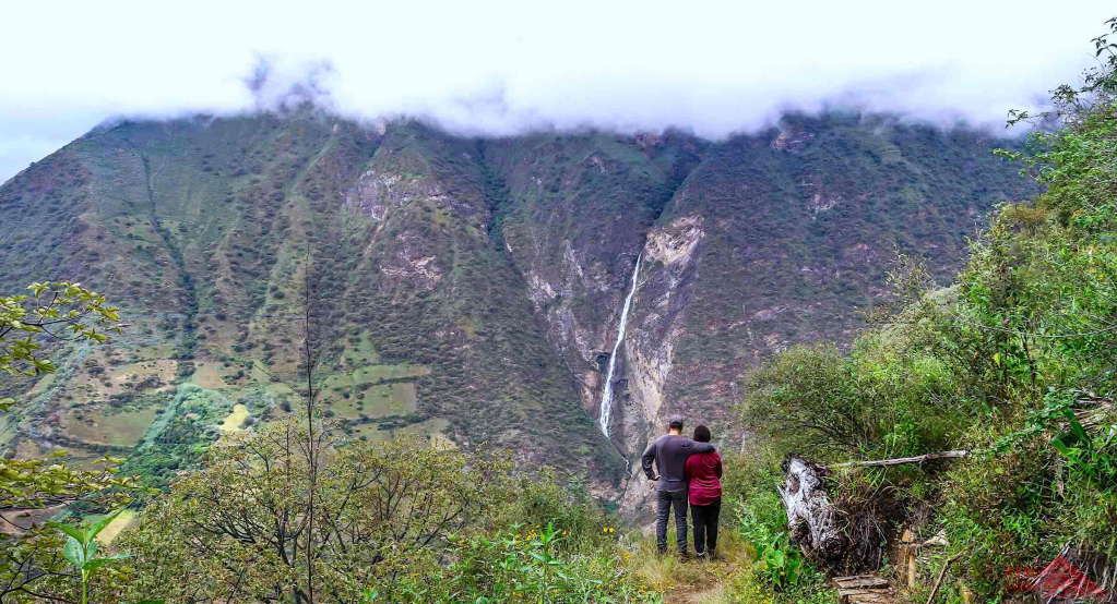
The route to the 10,000-foot-high Choquequirao is not for the faint-hearten. It takes most hikers two or three days to trek there and back, along a 39-mile trail that often hugs the cliff-side as the Apurímac River rages below. The route is strewn with rocks and lined with thorny branches.
Choquequirao, translated as cradle of gold in Peru’s Indigenous Quechua language, sits along a route used by pre-Columbian people to move between Andean peaks and jungle lowlands.
Both it and Machu Picchu (27 miles northeast) were mapped in the 1910’s by American explorer Hiram Bingham, who led four expeditions to the area sponsored by Yale University and the National Geographic Society.
The two sites have evolved quite differently since Bingham’s mapping efforts. By the 1920’s, Machu Picchu was heralded (incorrectly) as a lost city causing a spike in tourism. The terraced complex became Peru’s postcard to the world, a mountaintop citadel accessible by trail or by a train-bus combination.
In 1983, it was inscribed on the UNESCO World Heritage list, and the number of travelers increased further. In the first six months of 2022, the site attracted nearly 413,000 visitors, according to Peru’s Trade and Tourism Ministry.

Choquequirao, in contrast, only received 2,353 trekkers in the first half of this year. That’s not the only difference. While most visitors to Machu Picchu transit through the small town of Aguas Calientes (also known as Machu Picchu Pueblo), with its plentiful food and lodging, the route to Choquequirao lacks many creature comforts. Getting there is, as many prefer, an adventure.
As with Machu Picchu, Choquequirao shows the progression of Inca construction techniques, beginning with simple stone structures and evolving to finely hew massive blocks that interlock like puzzle pieces.
The heart of Choquequirao, with its mummy niches and ceremonial sacrifice platform, is smaller than what tourists see at Machu Picchu, but the complex itself is much larger.
Choquequirao’s size and remoteness mean that much of the site has never been excavated. Nelson Sierra, who operates a high-mountain trekking company, Ritisuyo, points to vine-covered elevations rising beyond the central clearing.
They are not small hills, but collapsed structures reclaimed by dense vegetation. “So much work is still needed here, but restoring it all would be a massive job.
As trekkers approach the ruins, the first thing they see are terraces, step-like platforms that turn hillsides into arable land, still used by farmers in highland Peru. Choquequirao has miles and miles of them, most still buried. The terraces stretch from the top of the ruins nearly a mile down toward the Apurímac River.
Work on the terraces led archaeologists to the stone llamas. Their white stone bodies stand in stark contrast with the gray walls, suggesting depth and dimension.
They reflect the sunlight when the rays first hit them each morning. Echevarría says the llama terraces may have been built as a symbolic offering to the sun god even when no actual live animals were available for sacrifice.
Many myths exist around Choquequirao,” says Echevarría. Indeed, Bingham and a number of explorers and researchers have floated theories about Choquequirao’s origins, its relationship to other ruins, and the role it played during the Inca Empire.
First, there’s a foundation myth holding that Manco Inca, the 15th-century Inca resistance leader, holed up in the citadel here for part of the 40 years he waged a guerrilla war against the Spanish invaders.
It is a nice story, but it has nothing to do with reality, says Echevarría. I have no doubt that Manco Inca was in Choquequirao, like he was at Machu Picchu, but it was not built for the resistance.
Samuel Quispe, who has worked as a guard, guide, and restorer at Choquequirao since the 1990s, posits that the complex was built by the Chanca, rivals to the Inca in the neighboring Apurímac region in the 14th and 15th centuries.

Echevarría disputes that theory, believing the majority of the structures went up during the expansion of the Inca Empire in the 15th century.
Former first lady of Peru Eliane Karp was instrumental in securing financial assistance to ramp up the restoration of Choquequirao in 2002. Now, she and her husband, former President Alejandro Toledo, are under suspicion for alleged corruption.
While none of the allegations relates to Choquequirao, the controversy has thrown everything the couple did while in power into question. Rumors abound that Karp helicoptered into Choquequirao to fly out crates of golden artifacts.
Karp did not cart off gold, but she did push for a cable car to access Choquequirao. In theory, the tramway could be good for Peruvian tourism and local economies. But it continues to politically divide communities, archaeologists, and politicians who must approve its funding.
An argument by design, and one that has raged around Machu Picchu, is the impact of tourists on the ruins. In 2016, UNESCO threatened to put Machu Picchu on a “danger” list because to block the number of visitors?
A cable car system would not only bring more visitors to Choquequirao, but also the sort of infrastructure that might damage the fragile site. Some complain that mass access to the sacred site could spoil its remote, undiscovered appeal—and the grassroots tourism outfits that now bring people here.
Melchora Puga, who offers lodging and a restaurant in Chiquisca on the Apurímac side of the trail, worries the cable car would force her and others to abandon their way of life.
Quispe, now a semi-retired mule driver, says the cable car would eliminate the livelihoods of a range of service providers whose businesses would be bypassed by a quick cable car ride.
One of his seven children, José Luis, is a mule driver, while another works for the government project restoring more of Choquequirao’s terraces. The family runs a small store and campground in Cocamasana along the trail.
The trek to Choquequirao is rigorous, and while it can be done in two days, a minimum of three is recommended to spend quality time at the ruins. The altitude begins at 10,000 feet at the trailhead and goes up and down (as low as 3,000 feet).
This can be a factor for many trekkers, particularly those who haven’t adjusted yet. The first day you’ll trek from Cachora straight down to Chiquisca (6,020 feet), close to the Apurímac River. Lodging, food, and drink are available.
You can overnight in Chiquisca or continue to the campground at Santa Rosa (6,200 feet), or to Marampata (9,400 feet), which also offers rooms and food. Choquequirao is about a two-hour hike from Marampata.
Tours, including porters and mule teams, are widely available to escort you from Cusco to Choquequirao and back. Seasoned trekkers utilize the four sites along the trail offering food, beverage, bathrooms, and lodgings.
A three-day tour with a porter runs around $700 per person. If you go solo, there is a $15 entrance fee.
National Geographic / ABC Flash Point News 2022.
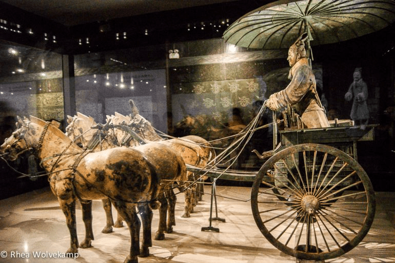
Terracotta Army of Shi Huangdi, first Emperor of China

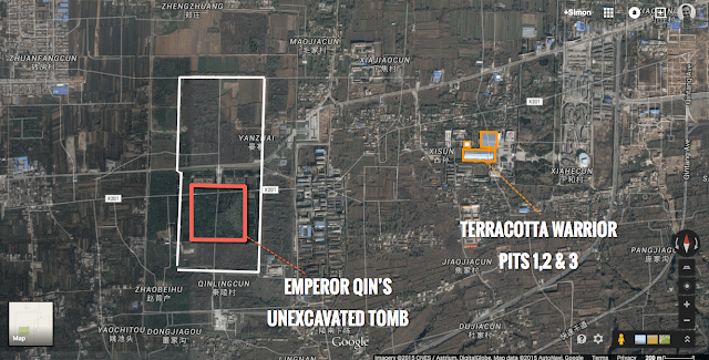
The Terracotta Army refers to the thousands of life-size clay models of soldiers, horses, and chariots which were deposited around the grand mausoleum of Shi Huangdi, first emperor of China and founder of the Qin dynasty, located near Lishan in Shaanxi Province, central China.
The purpose of the army was likely to act as guardian figures for the tomb or to serve their ruler in the next life. The site was discovered in 1974 CE, and the realistic army figures provide a unique insight into ancient Chinese warfare from weapons to armor or chariot mechanics to command structures.

Shi Huangdi was desperate for immortality, and in the end, his terracotta army of over 7000 warriors, 600 horses, and 100 chariots has given him just that, at least in name and deed. The site of the mausoleum is a UNESCO World Heritage Site even if the inner tomb itself has yet to be excavated.
Shi Huangdi (also known as Shi Huangti) was the king of the Qin state, who unified China from 221 BCE and then founded the Qin dynasty. He ruled as China’s first emperor until his death in 210 BCE.
His reign was short but packed full of incidents, most of them infamous enough to earn Shi Huangdi a lasting reputation as a megalomaniac despot.

The period saw the building of the Great Wall of China, the infamous Burning of the Books, where thousands of literary and philosophical works were destroyed, and the construction of a sumptuous royal palace.
The emperor seems to have been especially keen on acquiring immortality, a quest no doubt given further motivation by his survival of three assassination attempts.
Scientists were given the task of discovering life-prolonging elixirs, and young emissaries were sent across the Eastern Sea in search of the fabled Penglai, land of the immortals.
Failing in these endeavors to unnaturally prolong his life Shi Huangdi fell back on the age-old standby of autocratic rulers and had a huge mausoleum built instead. In fact, the whole massive project was begun in the early years of his reign as it required a prodigious amount of work to get it ready.
An administrative district was established at the site with 30,000 families forcibly relocated there and given the task of building the biggest tomb ever seen in China’s history or anyone else’s.
Eventually, no doubt as Huangdi realized time was running short, hundreds of thousands of forced laborers were sent to push the project to completion. One way or another, Shi Huangdi was going to be remembered long after his reign. The Terracotta Army seems to have achieved that goal.

The mausoleum of Shi Huangdi, actually an entire multi-burial complex which covers an incredible 35 to 60 square kilometers, was discovered in 1974 CE buried at the foot of the artificial Mt. Li near Lishan (modern Lintong), 50 km east of the Qin capital Xianyang in Shaanxi Province, central China.
The tomb itself remains excavated but its spectacular army of terracotta defenders has, in part, been revealed and already earned the site the title of “Greatest Tomb in the World”.
The tumulus of the buried tomb takes the form of a three-stepped pyramid, measures an impressive 1,640 meters in circumference, 350 meters along each side, and rising to a height of 60 meters. The whole is surrounded by a double wall.

Legend has it that the tomb contains vast riches but includes fiendish traps to ensure Huangdi rests forever in peace. The traps and the interior were described by the historian Sima Qian (146-86 BCE).
More than 700,000 convict laborers from the world were sent there. They dug through three springs, poured in liquid bronze, and secured the sarcophagus. Houses, officials, unusual and valuable things were moved in to fill it. He [Shi Huangdi] ordered artisans to make crossbows triggered by mechanisms.
Anyone passing before them would be shot immediately. They used mercury to create rivers, the Jiang and the He, and the great seas, wherein the mercury was circulated mechanically. On the ceiling were celestial bodies and on the ground geographical features. (Shelach-Lavi, 318).
The floor map with its geographical models and painted universe ceiling were symbolic of the emperor’s status as Son of Heaven and God‘s ruler on earth.
Qian also notes that members of Huangdi’s harem were entombed with their dead emperor and many craftsmen and laborers, too, in order to keep the fabulous wealth of Huangdi’s grave goods a secret for all time.
Besides infantry, the army includes 600 horses and almost 100 chariots which carry officers and riders and have either a two, three, or four-horse team. The soldiers were set in regular rows and are depicted in different postures – most are standing while some are crouching.

Their mix and particular arrangement of officers (slightly taller than everyone else with their general being tallest of all), cavalry, crossbowmen, skirmishers, archers, charioteers, and grooms give the illusion of a complete battlefield army ready for action.
There are light infantry units with archers positioned at the flanks and front, the heavy infantry behind them, while chariots bring up the rear with their officers, matching the troop deployments mentioned in ancient military treatises.
The scale of the enterprise must have required a huge quantity of firewood to fuel the pottery kilns that made the figures, not to mention the countless tons of clay from local deposits needed to make figures weighing up to 200 kilos each.

Besides the breathtaking finished result, the undertaking was a triumph of organization and planning.
Other non-terracotta artifacts discovered at the site as archaeologists work their way ever-closer to the central tomb area include half-size bronze and wood chariots pulled by teams of four bronze horses.
And also bronze sculptures of birds, notably 3 very fine cranes, 20 swans, and 20 geese, all set up by a 60-metre long pond to recreate a river scene.
There is a replica of a stable, foundations of temple structures, and pottery storage jars within a granary building. There is an armory measuring 100 x 130 meters packed with hundreds of replicas of armor and helmets, each piece meticulously made from hundreds of small stone pieces.
There are tombs of other royal family members and high-ranking officials and statues representing them, including one tomb of a court acrobat. Then there is a long list of real objects, not simply models.
These include 31 exotic birds and animals each buried in their own wood coffin, real horses (300 in one pit alone) and the skeletons of over one hundred humans with accompanying bronze plaques indicating they were laborers and convicts who died while working on the tomb.
All of these items taken collectively, along with their particular layout and the idea of the map and sky of the inner tomb, were designed to demonstrate that China’s first emperor ruled, if not the whole world, then certainly the central and most important part of it in Chinese eyes.
World History Encyclopedia / Crickey Conservation Society 2022.
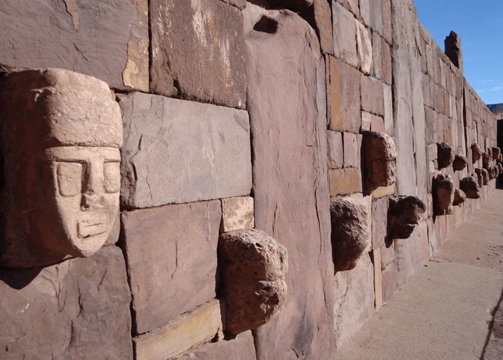
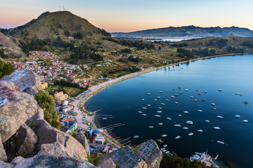
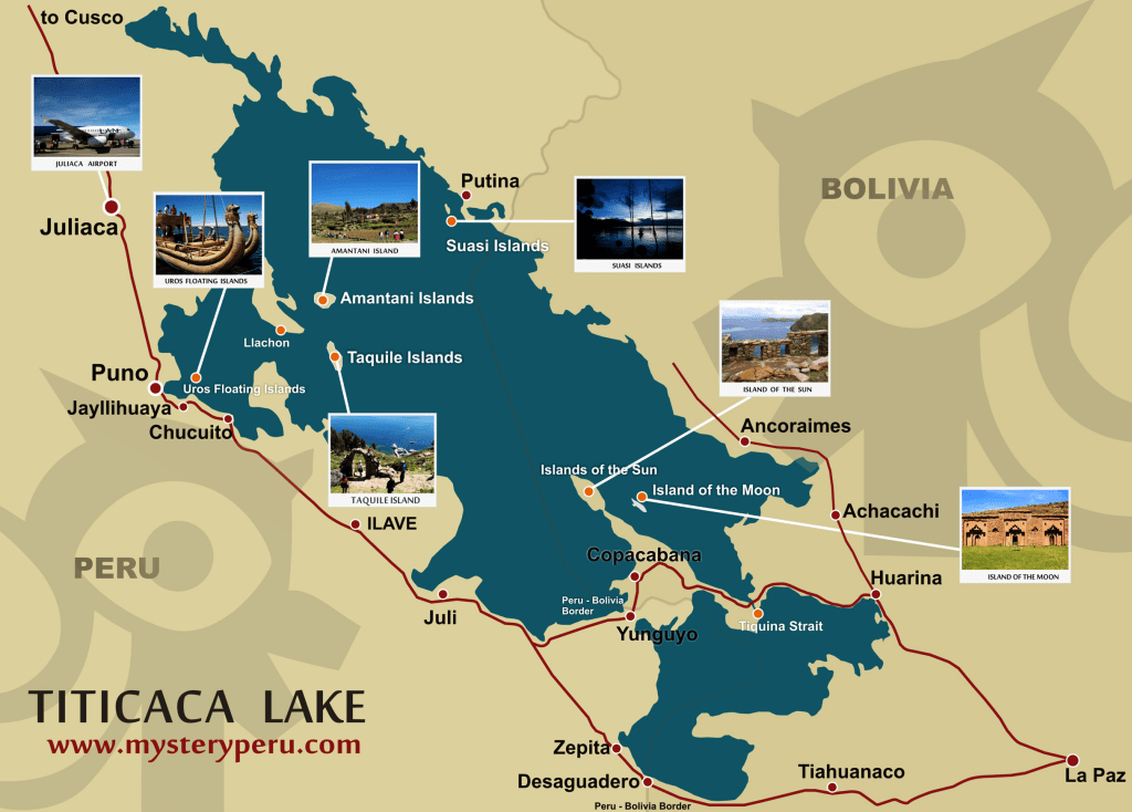
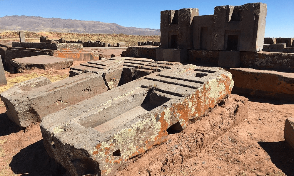
Tiahuanaco @ Lake Titicaca in Bolivia

Tiwanacu, also spelled Tiahuanaco, isa major pre-Columbian civilization known from ruins of the same name that are situated near the southern shore of Lake Titicaca in Bolivia. The main Tiwanaku site was added to UNESCO’s World Heritage List in 2000.
Some scholars date the earliest remains found at the site to the early part of the Early Intermediate Period (c. 200 bc–ad 200); others suggest that the culture is evident in artifacts from the 2nd millennium before Christ.
Probably much of the site, including many of the major buildings, dates from the latter half of the Early Intermediate Period (ad 200–600); some construction, however, must have continued into the Middle Horizon (ad 600–1000), for during this period Tiahuanaco influences are seen at Huari (Wari) and elsewhere in the central and southern Andes.
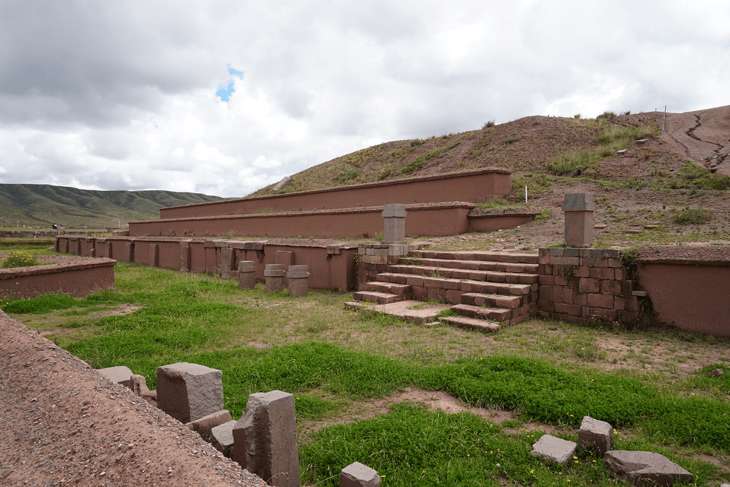
The principal buildings of Tiahuanaco include the Akapana Pyramid, a huge platform mound or stepped pyramid of earth faced with cut andesite; a rectangular enclosure known as the Kalasasaya, constructed of alternating tall stone columns and smaller rectangular blocks; and another enclosure known as the Palacio.
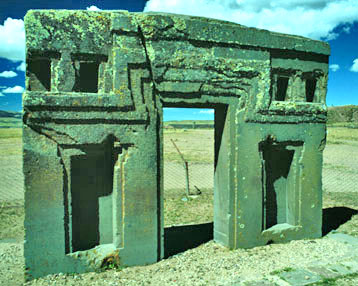
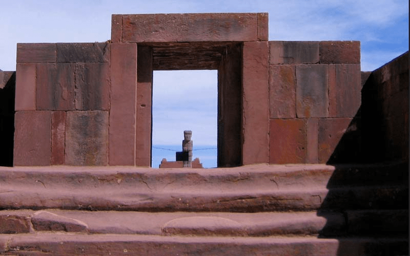
A notable feature of the Kalasasaya is the monolithic Gateway of the Sun, which is adorned with the carved central figure of a staff-carrying Doorway God and other subsidiary figures, sometimes referred to as angels or winged messengers.
A great number of freestanding carved stone figures have also been found at the site. Characteristic pottery is a flared beaker form, painted with black, white, and light red representations of pumas, condors, and other creatures on a dark red ground color.

It has been speculated that the people who built the splendid Tiwanacu complex, whose culture had vanished by ad 1200, were the ancestors of the present-day Aymara Indians of highland Bolivia.
In the late 20th century, archaeologists discovered new information concerning the Tiwanacu site.
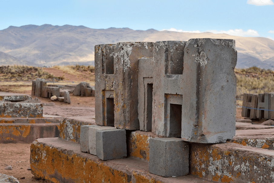
Formerly thought to have been largely a ceremonial site, the Puma Punku since has been revealed as a once-bustling metropolis, the capital of one of the greatest and most enduring of ancient civilizations; nonetheless, relatively little is known about it.
Tiahuanaco influence @ Lake Titicaca was in great measure a result of its remarkable agricultural system. This farming method, known as the raised-field system, consisted of raised planting surfaces separated by small irrigation ditches, or canals.
This system was designed in such a way that the canals retained the heat of the intense sunlight during frosty nights on the Altiplano and thus kept the crops from freezing. Algae and aquatic plants that accumulated in the canals were used as organic fertilizer on the raised fields.
During the height of its power, Tiahuanaco dominated or influenced large portions of what are now eastern and southern Bolivia, northwestern Argentina, northern Chile, and southern Peru.
The revived use of the raised-field system by some Bolivian farmers in the late 20th century resulted in increased agricultural production.
The document was adopted by UNESCO in 1972 and formally took effect in 1975 after having been ratified by 20 countries. It provides a framework for international cooperation in preserving and protecting cultural treasures and natural areas throughout the world.
Britannica / Crickey Conservation Society 2022.
Like in many other regions of the World, Caribbean Coral Reefs are disappearing

Coral reefs form some of the most diverse ecosystems on the planet. But, for most of us, they are hidden from view. We are blind to how these ecosystems might be changing.
Coral reefs face a number of threats – most of them are increasing with human pressure. One of the most pressing is coral bleaching: potentially fatal events caused by our warming oceans.
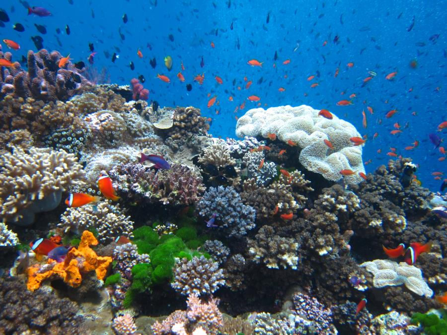
Corals are animals that belong to the phylum of cnidarians – a group of more than 11,000 water-based animals. Most live in marine environments. Corals use calcium carbonate in waters to build a hard exoskeleton.
But the key to their success is their symbiotic relationship with algae. They contain microscopic algae called zooxanthellae that photosynthesize (just like any other plant would), providing corals with the majority of their energy. Corals wouldn’t be able to survive without them.
This important relationship can be disrupted when corals are put under stress. One of the biggest stressors is warmer temperatures. When exposed to warmer waters, corals expel their algal symbionts, meaning they lose their source of energy. Without their algae, corals turn pale; this is why this process is called ‘bleaching’.
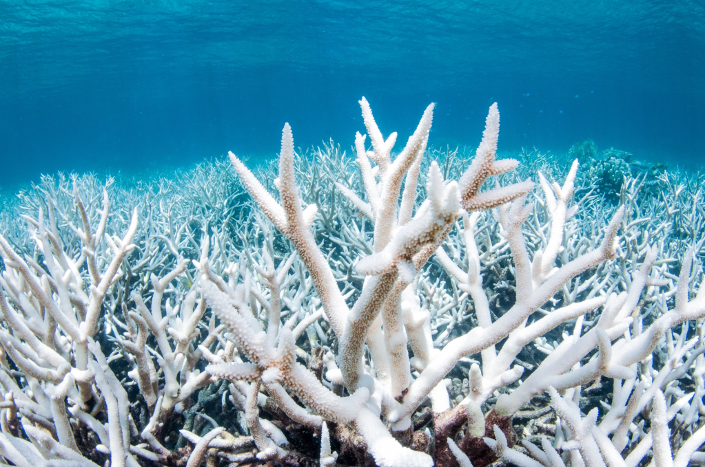
It should seem obvious why coral bleaching is a growing concern for the world’s coral reefs. With climate change, the global average temperature is rising. We often think about atmospheric or terrestrial temperatures, but our oceans are warming too.
The global average sea surface temperature has increased by around 1°C since 1850.19 Importantly, the peak temperatures in summer – when bleaching events are most likely to occur – has also increased in recent decades.

Coral propagation by fragmentation is a restoration technique that Bonaire project began with in 2012. This method is based on the asexual reproduction of corals and allows us to harness the natural process of fragmentation to propagate large numbers of corals.
It enables Bonaire to produce thousands of corals without harming the wild populations. By utilizing fragmentation, we can quickly restore coral populations using a well-established approach that has been used for years by reef restoration programs worldwide.

Nurseries which are distributed among several locations on the leeward side of Bonaire and Klein Bonaire can host over 15,000 corals. Each coral morphology is different and therefore there is no “one size fits all” approach. Depending on the species, corals are either hung from the branches of the trees or secured on trays.

Corals are selected in the nursery to be out-planted to the reef once they are “reef-ready”. This means their age, size, and overall health, makes them better-suited for survival when exposed to stressors that exist in greater abundance outside of a nursery environment.
Genetically diverse corals are then tagged, taken to a selected restoration site, and out-planted back to the reef, using various methods. Depending upon the species of coral and the environmental conditions of the reef, a variety of out-planting methods are used.

Like in many other regions of the world, coral reefs in the Arabian Peninsula, Pacific and the Caribbean have been subject to an increasing intensity of disturbances in the recent years.
According to a leading environment expert, a rise in the of temperature of the water has had a negative effect on the ecosystem in the region including Arabian Gulf and the Sea of Oman.

As a result, 90% of coral reefs in this region have been bleached and are dying. The forest of the Arabian Gulf/Oman Sea ecological region include part of the southwest and all southern coast covering 2.039.964 hectares.
While in the Sea of Oman area, which includes a part Hormozgan province to Sistan-Baluchistan (border of Iran and Pakistan), Mesquites and acacia species are the main vegetation covers. Gum Arabic tree, used in boat production, are scattered in this area.
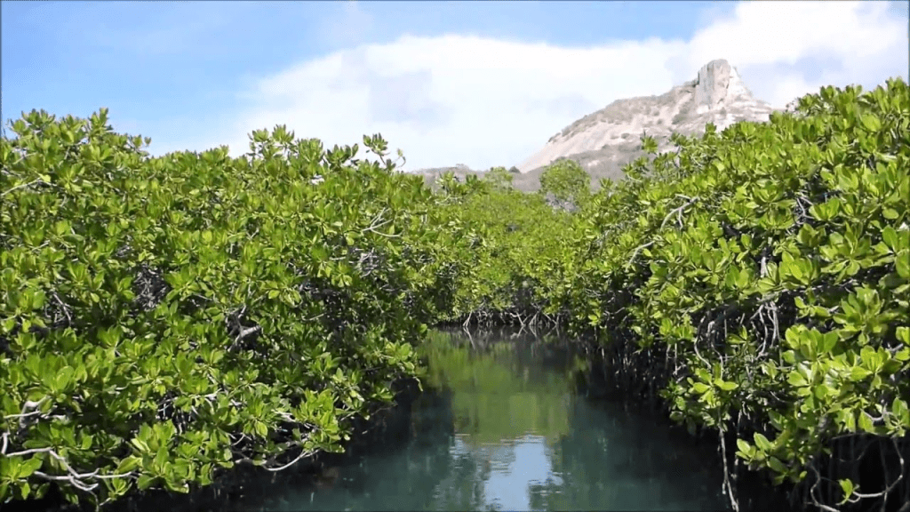
Mangrove forest which consists of two species of grey mangroves and loop-root mangroves, are also spread in this area. The mangrove forest habitat is located between the tides of the seas.
Experts believe that that urban and industrial effluents from desalination plants increase the salinity of the Arabian Sea, in addition to climate change, which has destroyed coral reefs as sea water gets warmer, while the habitat and breeding ground 75% of marine species is among the coral reefs.
Crickey Conservation Society 2022.
Indonesia Orangutan Jungle School

Deforestation is the greatest threat to the orangutan’s survival, and a great percentage of deforestation is set in motion to convert the land to oil palm cultivation.
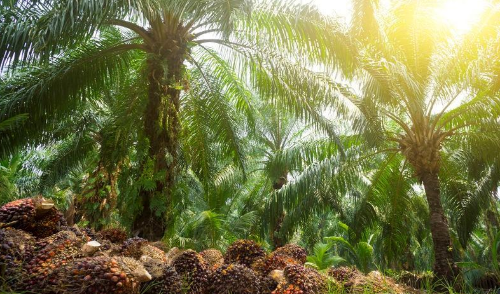
The rain forest, the natural habitat of the orangutan, is cleared for the benefit of plantations that can produce cheap vegetable oil for the rest of the world. Today, 92% of the world’s collective consumption of palm oil comes from two countries: Indonesia and Malaysia.

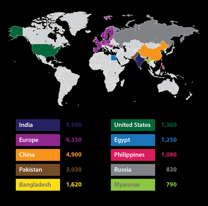
The demand for palm oil is increasing, both in Indonesia and globally. For instance, Denmark imports more than 150,000 tons of palm oil annually despite an intensified international focus on the environmental consequences of palm oil.
Palm oil as a vegetable oil is added in food, cleaning materials, and several other products. Palm oil is the most common vegetable oil in the world, and Europe has gradually increased the use of palm oil in biodiesel in the last few years.
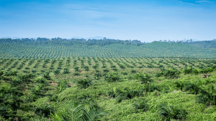
Half of the Borneo’s rain forests are cleared to benefit the palm oil industry and its sub-groups. The deforestation leaves the Orangutan and thousands of other species without a home. Consequently, their ability to survive is affected greatly.
The Orangutans are isolated within small enclaves of the rain=forests, unable to forage for food and too close to humans. Additionally, the forest is often burnt after having been cleared. This can start uncontrollable forest fires, which destroy even more of the forest and damage the climate.
The problem is not the oil palm plantations or the palm oil in themselves, except for chopping down the oxygen supply as an alternative for diesel fuel for the profit-based automotive industry.
The problem is rather the destruction of the rain forest, and thus the orangutan’s habitat, for the benefit of palm oil production. In terms of the orangutan’s survival, a paradox exists in that the orangutan is protected but its rain forest home is not?
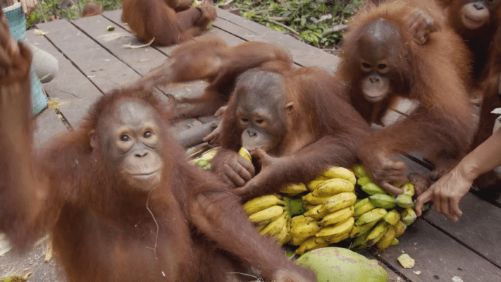
The Orangutan Jungle School series will take viewers on a roller coaster ride of the adventures, trials and tribulations, heartaches, fun, friends, failures and successes of all the orangutans who attend the BOS Foundation’s unique school in a Borneo jungle in Central Kalimantan Indonesia.
They are all orphans of murdered Orangutans and are learning skills that one day will enable them to live once again in a true wilderness? We follow the progress of the only known albino orangutan on the planet – beautiful Alba as plans are made for her future.
With their rain forest habitat being destroyed by deforestation at an alarming rate there are currently over 300 students going through the school system divided up to suit the age and skill range from babies just a few weeks old, to teenagers and young adults.
Through their lessons in baby nursery, forest school and the island university all these youngsters are adapting to the challenges of being taught survival skills by humans as they also deal with the ever-increasing social pressures of life in a tightly-knit community which could determine the future of their species.
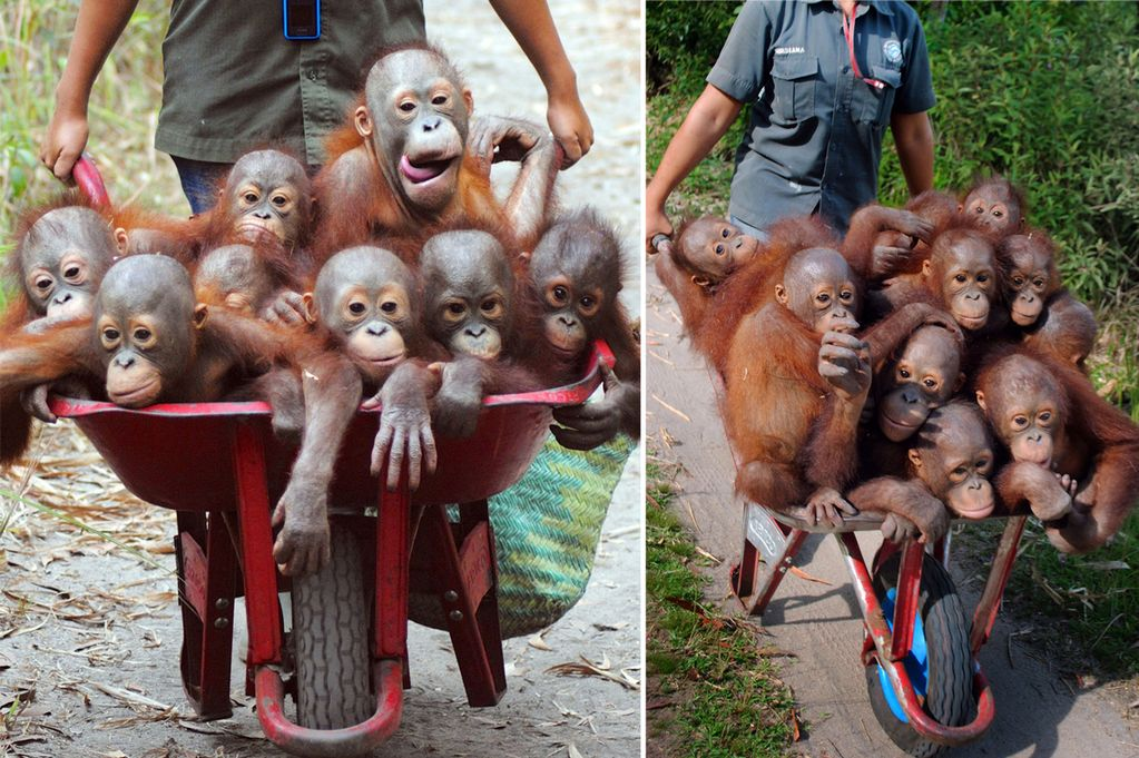
This incredible show has it all: friendship, romance, bullies, danger, drama, raging hormones, fear, humor, medical emergencies, heartache, rescues, reunions, attempted escapes, and even teenage pregnancy! And of course most importantly – actual release for graduates – back into the wild.
You’ve experienced it in your own lives. Now see it play out in the real lives of these orphaned orangutans… many of whom will steal your heart and maybe stop buying excessive products made with palm oil products.
Save the Orangutan Organization / Crickey Conservation Society 2022.
Korean Jang Bogo Research Station Antarctica

Korea is becoming a significant player in Antarctic research and Jang Bogo, by Space Group (South Korea), will be one of the largest year-round bases on the continent when it opens in 2014.
The station’s aerodynamic triple-arm design will provide resistance to the elements and accommodate up to 60 personnel during the busy summer season.

Wrapped in a special aluminum case its extensive glazing offers magnificent panoramic views whilst withstanding powerful winds, below 40 degree Celsius temperatures, blizzards and unfathomable loads.
Located 10,000 miles from the UK on a floating ice shelf, the new station is designed to be self-sufficient, able to withstand freezing winter temperatures of minus 55ºC, have minimal impact on Antarctica’s pristine environment, and be an aesthetically stimulating place to live and work.

Antarctica is Earth’s southernmost continent. It contains the geographic South Pole and is situated in the Antarctic region of the Southern Hemisphere, almost entirely south of the Antarctic Circle, and is surrounded by the Southern Ocean.

At 14,000,000 square kilometers (5,400,000 square miles), it is the fifth-largest continent.
For comparison, the continent is nearly twice the size of Australia. The continent is on average, is the coldest, driest, and windiest continent, and has the highest average elevation of all the continents. Antarctica is a desert, with annual precipitation of only 200 mm (8 in) along the coast and far less inland.
The Jang Bogo Station in Terra Nova Bay, Antarctica is a permanent South Korean research station. It is the second base of South Korean Antarctic research mission (after King Sejong Station), and the first that is located in mainland Antarctica.
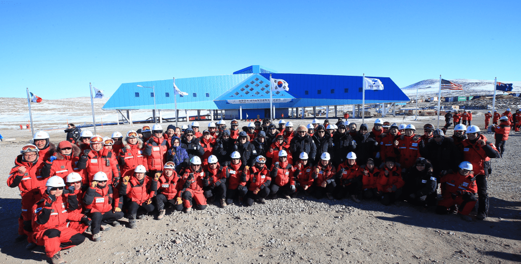
Completed in February 2014,[1] the station houses 15 people in winter and 60 in summer in a 4000 square-metre building with three wings, and is one of the larger permanent bases in Antarctica.
The base, named after an eighth-century maritime ruler of Korea, is located in the Ross Dependency and near the Zucchelli Station of Italy.
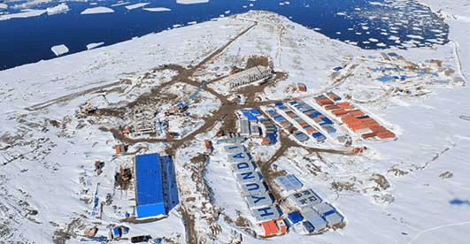
It was built by Hyundai Engineering and Construction, with material shipped from Busan to Lyttelton, New Zealand for transfer to the new Korean icebreaker, the RS Araon.
For aeronautic operations such as the transport of personnel or cargo, the base is supported by the Italian Antarctic Program using the ice runway operated by Zucchelli Station in Tethys Bay.
e-Architect.com / Crickey Conservation Society 2022.
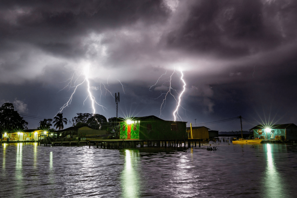
Venezuela’s Maracaibo Lake is known as the Lightning Capital of the World

If one likes lightning storms, then the most extreme lightning place on earth is Lake Maracaibo in Venezuela. It has so much lightning that it is known as the lightning capital of the world.
So much lightning lights up Lake Maracaibo, that sailors used to use it to guide their ships and it earned itself the nickname “Lighthouse of Maracaibo.”
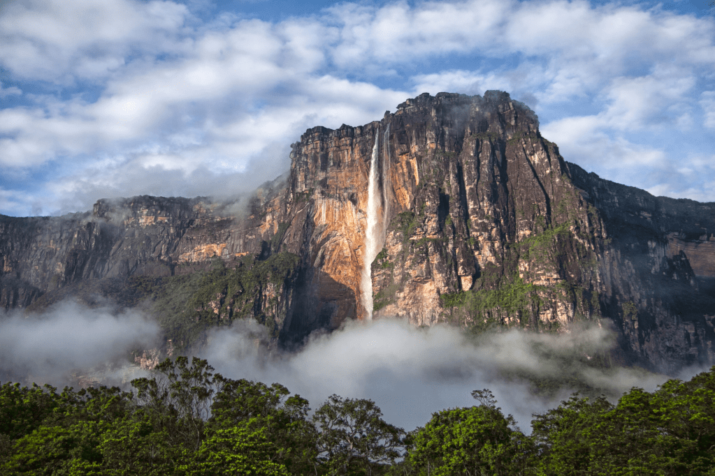
Venezuela is a very beautiful country and rich in many things. One can enjoy its tropical beaches, lush rain-forests, and intense displays of lightning. Venezuela has more than just the craziest lightning hot spot in the world, it also boasts Angel Falls – the highest waterfalls in the world.
Lake Maracaibo is a large brackish tidal bay (aka a tidal estuary) and is variously thought of as a lake, bay, or lagoon.

In the past, it was once a true lake and the largest in South America as well as being one of the oldest lakes on Earth – some 20-36 million years old.
The lake is famous for its weather phenomenon called Catatumbo lightning which makes Lake Maracaibo produce more lightning than anywhere else on earth. If one is a lightning enthusiast, consider adding this to a future itinerary.

The lightning is thought to be the result of winds blowing across the lake and the surrounding swampy plains. The air masses meet the high mountain ranges of the Andes, the Perijá Mountains, and Mérida’s Cordillera. These ranges enclose the plain below from three sides.
Towering Mountain Ranges Hem The Lake In From Three Sides Trapping The Air.
Heat and moisture are collected across the low plains and create electrical charges with the end result being many thunderstorms. There is almost continuous lightning (mostly within the clouds).

The area around the lake is also particularly rich in oil and vast quantities have been removed from this region ever since it was discovered. Also gold and diamonds are plentiful in Venezuela.
Since early explorers, Lake Maracaibo has been known as the “Lighthouse of Maracaibo” and its lightning is visible for miles around. It may come as a surprise but the first colonists of Venezuela were not the Spanish but rather the Germans.
Guinness World Record: Lake Maracaibo Holds The Record For The Highest Concentration of Lightning.

It was the Germans who named the colony “Klein-Venedig” or “Little Venice” – that the Spanish later changed to Venezuela.
German activity here lasted from 1528 to 1546 and Venezuela was the most significant part of German colonization of the Americas (there were some others). But eventually the Spanish took over.
According to a study, Africa has the most lightning hot spots in the world, followed by Asia, South America, North America, and Australia (not much happening in Europe).

On average the earth produces around 44 flashes of lightning every second annually. It produces the most (around 55 flashes per second) in the boreal summer and the least (around 35 flashes per second) in the austral summer.
On average, Lake Maracaibo has some 233 flashes per square kilometer every year with thousands occurring per night. Often there is no thunder – just lightning. And the lightning occurs in around 300 nights in the year with September being the peak month.
Unfortunately, for the last 10 years or so, Venezuela has been sanctioned by the USA and IMF at put on a designed people’s list of countries they would never visit. But hopefully in the future things will change and the country will be safe to visit again. It is a very rewarding country to explore.
So for the greatest density of lighting in the world, go to Venezuela. But if one is in Africa (and especially DR Congo with five of the top 10 world lightning hot spots) one can find many lightning hotspots lighting up the sky.
The Travel.com / ABC Flash Point News 2022.
