
People of the Americas have a Female Lineage from China

A groundbreaking new study has harnessed the power of mitochondrial DNA to trace a marvelous female lineage from northern coastal China all the way to the Americas. This has revealed compelling evidence of not one, but two migrations, during the last Ice Age, and the subsequent melting period!
This discovery challenges previous beliefs about the ancestry of Native Americans and sheds new light on the complicated history of human migration and settlement in the Americas.

Coinciding with the timeline of the second migration is another branch of the same lineage migrating to Japan. This is a potential explanation for Paleolithic archaeological similarities between the Americas, China, and Japan, explains the study published in the latest edition of Cell Reports .
It has popularly been believed that ancient Siberians, who crossed over a land bridge in the Bering Strait linking modern Russia and Alaska, were the sole ancestors of Native Americans.
This accepted wisdom is now being challenged in many ways, thanks to newer and newer scientific studies, like this. The new science heavily points towards multiple waves of human migration from various parts of Eurasia to the Americas.

The Asian ancestry of Native Americans is more complicated than previously indicated, says first author Yu-Chun Li, a molecular anthropologist at the Chinese Academy of Sciences.
A team of researchers from the Chinese Academy of Sciences embarked on a quest to trace a lineage that could potentially connect East Asian Paleolithic populations to the founding populations in Chile, Peru, Bolivia, Brazil, Ecuador, Mexico, and California.
This lineage, crucially present in mitochondrial DNA, provides a unique window into tracing kinship through the maternal line, according to a press release . The lineage, known as D4h, was used in the research, allowing the team to trace maternal ancestry over the course of 10 years.

The research team from the Kunming Institute of Zoology embarked on an extensive analysis of over 100,000 contemporary and 15,000 ancient DNA samples collected across Eurasia. This led them to the identification of 216 contemporary and 39 ancient individuals belonging to this rare lineage.
After a thorough comparison of accumulated genetic mutations, geographical locations, and carbon dating, the researchers successfully traced the lineage’s branching trajectory.
Evidence of two migration events from northern coastal China to the Americas emerged – the first of these occurred roughly between 19,500 and 26,000 years ago, during the Last Glacial Maximum .
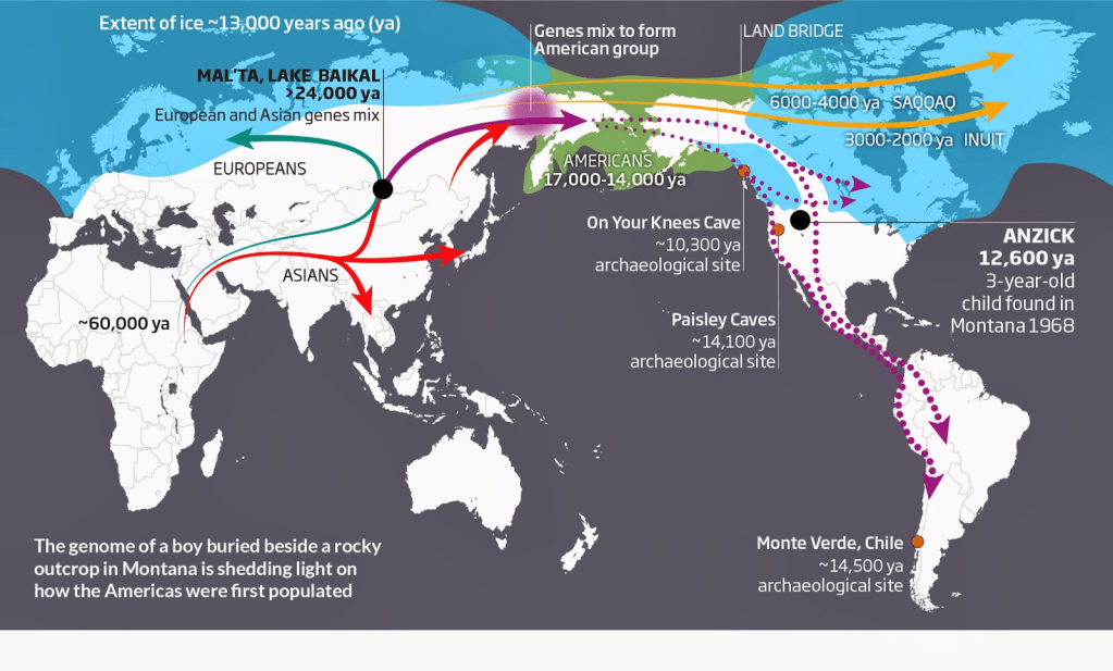
Potentially, the severe ice sheet coverage in northern China (at its peak) rendered the region inhospitable for human habitation during this period.
The second migration unfolded during the subsequent deglaciation or melting period, spanning from 19,000 to 11,500 years ago, a period of relative warming.
The favorable climatic conditions during this phase likely contributed to a rapid population increase, causing (perhaps even forcing) an expansion of human communities into other geographical regions.
It is likely that both groups arrived in the Americas via the Pacific coast, rather than venturing through the inland ice-free corridor, which would not have been accessible during that time.

During this deglaciation period, another group branched off from northern coastal China and made their way to Japan, forging an intriguing connection. We were surprised to find that this ancestral source also contributed to the Japanese gene pool, especially the indigenous Ainus, says Li.
This serves as a solid explanation for the archaeological similarities observed among the Paleolithic peoples of China, Japan, and the Americas. This is observed particularly in their shared crafting techniques for stemmed projectile points used in crafting arrowheads and spears.
This suggests that the Pleistocene connection among the Americas, China, and Japan was not confined to culture but also to genetics, says senior author Qing-Peng Kong, an evolutionary geneticist at the Chinese Academy of Sciences.

Although the focus of the study primarily centered on mitochondrial DNA, complementary evidence from Y chromosomal DNA further indicates the presence of male ancestors of Native Americans in northern China during the same period as their female counterparts.
The origins of several founder groups are still elusive or controversial. Next, we plan to collect and investigate more Eurasian lineages to obtain a more complete picture on the origin of Native Americans, concludes Kong.
Ancient Origins / Crickey Conservation Society 2023.
Massive Outbreak of Jellyfish could now spell more trouble for Fisheries

The world’s oceans have been experiencing enormous blooms of jellyfish, apparently caused by over-fishing, declining water quality, and rising sea temperatures.
Now, scientists are trying to determine if these outbreaks could represent a “new normal” in which jellyfish increasingly supplant fish.

Among the spineless creatures of the world, the Nomura’s jellyfish is a monster to be reckoned with. It’s the size of a refrigerator — imagine a Frigidaire Gallery Premiere rather than a hotel minibar — and can exceed 450 pounds.
For decades the hulking medusa was rarely encountered in its stomping grounds, the Sea of Japan. Only three times during the entire 20th century did numbers of the Nomura’s swell to such gigantic proportions that they seriously clogged fishing nets.
Then something changed. Since 2002, the population has exploded — in jelly parlance, bloomed — six times. In 2005, a particularly bad year, the Sea of Japan brimmed with as many as 20 billion of the bobbing bags of blubber, bludgeoning fisheries with 30 billion yen in losses.

Why has the Nomura’s jellyfish become a recurring nightmare?
The answer could portend trouble for the world’s oceans. In recent years, populations of several jellyfish species have made inroads at the expense of their main competitor — fish — in a number of regions, including the Yellow Sea, the Gulf of Mexico, and the Black Sea.
Over-fishing and deteriorating coastal water quality are chief suspects in the rise of jellies.

Global warming may be adding fuel to the fire by making more food available to jellyfish and opening up new habitat. Now, researchers fear, conditions are becoming so bad that some ecosystems could be approaching a tipping point in which jellyfish supplant fish.
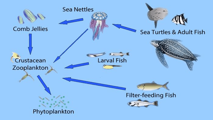
Essential to thwarting any potential jellyfish takeover is a better understanding of the complicated dynamics between fish and jellyfish. Jellyfish — free-swimming gelatinous animals — are a normal element of marine ecosystems. Fish and jellyfish both compete for plankton.
The predators keep each other in check: 124 kinds of fish species and 34 other species, including leather-back turtles, are known to dine on jellyfish, while jellies prey on fish eggs and, occasionally, on fish themselves. Juvenile fish of some species take refuge amid tentacles and eat jellyfish parasites.

Fish and jellyfish interact in complex ways, says Kylie Pitt, an ecologist at Griffith University in Australia.
Over-fishing can throw this complex relationship out of kilter. By removing a curb on jellyfish population growth, over-fishing opens up ecological space for jellyfish, says Anthony Richardson, an ecologist at CSIRO Marine and Atmospheric Research in Cleveland, Australia.
And as jellyfish flourish, predating on fish eggs takes a heavier and heavier toll on battered fish stock.
When an ecosystem is dominated by jellyfish, fish will mostly disappear, says ecologist Sun Song, director of the Institute of Oceanology in Qingdao, China. Once that happens, there is almost no method to deal with it.
Just think of attempting to purge the Sea of Japan of billions of Nomura’s jellyfish, many of them hovering meters below the surface and therefore invisible to satellites or the naked eye.
Total jelly domination would be like turning back the clock to the Precambrian world, more than 550 million years ago, when the ancestors of jellyfish ruled the seas.

Sun and others are racing to get a handle on the likelihood of such a marine meltdown coming true. Like their foe, the subject is slippery. It’s an enigma, for starters, why particular jellyfish run rampant.
The troublemakers are only a small fraction of the several thousand species of jellyfish out there, says Richardson. These uber-jellies reproduce like mad, grow fast, eat most anything, and can withstand poor water quality.
The big question is whether these cockroaches of the sea are poised to hijack marine ecosystems. There’s anecdotal evidence that jellyfish blooms are becoming more frequent. But there are also cases in which jellyfish gained the upper hand on an ecosystem, only to suddenly relinquish it.

For instance, biomass of Chrysaora jellyfish in the east Bering Sea rose sharply during the 1990s and peaked in 2000. Chrysaora then crashed and stabilized after 2001, apparently due to a combination of warmer sea temperatures and a rebound in numbers of walleye pollock, a competitor for zooplankton.
The jury is out on whether other jelly-blighted waters can regain ecological balance as quickly as the Bering Sea did. For that reason, says Pitt, no one can say for sure whether severe jellyfish blooms are a passing regional phenomenon or a global scourge requiring urgent measures to combat their spread.
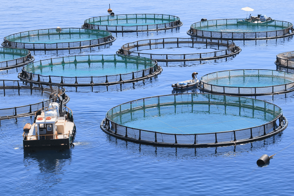
Jellyfish clearly have an impact on human activity. Besides fouling fishing nets, they invade fish farms, block cooling intakes at coastal power plants, and force beach closures. Some jellies pose a mortal threat.
Dozens of people die each year from jellyfish stings, far more than from encounters with other marine creatures, including sharks. A box jellyfish, the Chironex sea wasp, may be the most lethal animal on the planet: Its toxin can kill a person in three minutes.

Global warming may allow deadly jellyfish, now mostly found in tropical and subtropical waters, to conquer new turf in temperate waters as sea surface temperatures rise, warns Richardson. It’s very likely that venomous jellyfish will move toward the poles.
While that could be a big blow for tourism, far more worrisome to many researchers is the threat that jellies pose to fish stocks. The most important helping hand for jellyfish may be over-fishing.
In one well-documented episode, the devastation of sardine stocks appear to have cleared the way for the rise of Chrysaora off Namibia, in waters known as the northern Benguela. Recent research cruises there have hauled in about four times as much jelly biomass as fish biomass.
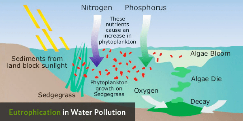
Another ecosystem tweak that benefits jellyfish is eutrophication. A flood of nutrients from agricultural runoff and sewage spurs phytoplankton growth in coastal waters, providing a feeding bonanza for jellyfish.
Eutrophication, usually around the mouths of major rivers, can also create low-oxygen dead zones that jellyfish generally tolerate better than fish.

Global warming may also abet regime change. Warmer ocean temperatures are correlated with jellyfish blooms. A possible explanation, says Richardson, is that warming leads to nutrient-poor surface waters. Such conditions favor flagellates, a kind of zooplankton, over diatoms, a kind of phytoplankton.
Flagellate-dominated food webs may be more favorable to jellyfish.
For reasons yet to be fully fathomed, the waters off North Asia may be acutely vulnerable to a jellyfish invasion. Since 2000 or so, the Nomura’s jellyfish and two other species — Aurelia aurita and Cyanea nozakii — have been plaguing the Yellow Sea.

In the past 5 years, anchovy catches there have decreased 20-fold, says Sun. Perhaps as a result, just like off Namibia, jellyfish are seizing the day. During a research cruise in the Yellow Sea in the summer of 2009, jellyfish amounted to 95% of the biomass netted by the scientists.
The bottom line is that multiple factors may favor jellyfish over fish, says Shin-ichi Uye, an ecologist at Hiroshima University who has charted the rapid rise of the Nomura’s jellyfish in the Sea of Japan.
The recipe for what makes jellyfish run amuck likely varies by region, and for that reason may take time to decipher. But the future of the world’s fisheries may well depend on it.
Yale Environment 360 / Crickey Amigu di Natura 2023.
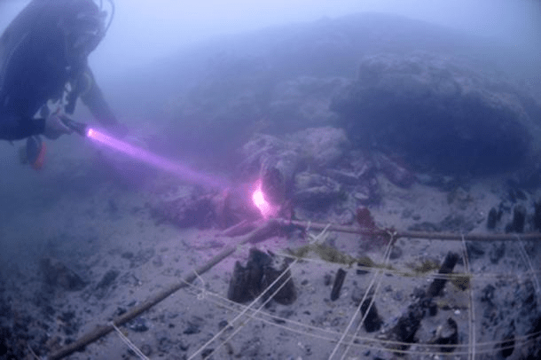
Race against Time to save the 33,000-Year-Old Underwater Cosquer Cave

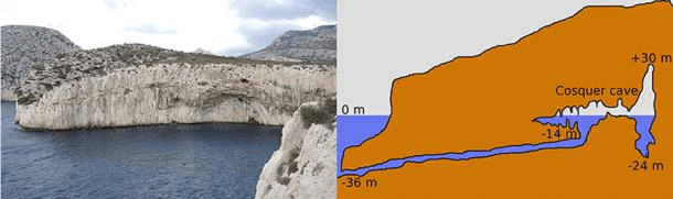
During glacial Pleistocene, the entry to the famous Cosquer Cave was 100 meters (330 ft) above sea level, but the Holocene sea level rise, propelled lately by climate change, has meant that the entrance to the cave is now 37 meters (121 ft) below sea level.
Renowned for being the only place in the world where prehistoric underwater marine art can be found, scientists are now racing against time to save the art from climate change and pollution.
Over 30,000 years old and created over 15 millennia, the spectacular cave art at Cosquer Cave is in grave danger, with a 12 cm (almost 5 in) rise in sea level in 2011 alone.
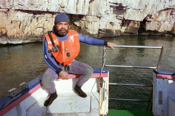
With sea levels rising a few millimeters every year, and the combination of water and plastic pollution is doing more and more damage to the art, archaeologist and diver Luc Vanrell and his colleagues have taken matters into their own hands.
While in use, Cosquer Cave was 10 kilometers (6.2 mi) away from the coast. “At the time we were in the middle of an ice age and the sea was 135 meters [443 ft] lower” than it is today, highlighted archaeologist Michel Olive in AFP.
The entrance to the cave was on a little promontory facing south over grassland protected by cliffs. It was an extremely good place for prehistoric man. Olive has been put in charge of the academic research and study of the cave.
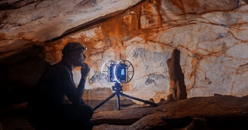
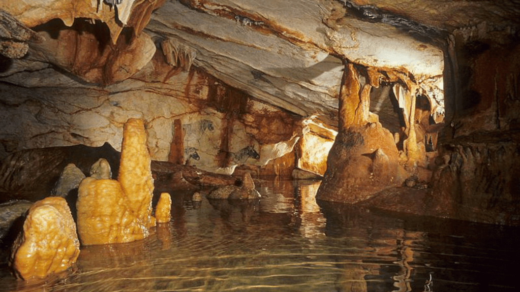
Though four-fifths of the cave has inadvertently been lost or submerged due to the passage of time, 229 rock art figures depicting 13 species remain on the wall. An added bonus is 69 red or black hand prints , including three that have been left by mistake, some of these made by children.
In total, 600 signs, images and rock carvings, which include aquatic life never seen before in cave paintings have been found. The cave was occupied between 33,000 and 18,500 years ago, but no traces or evidence of people having lived there have been found.

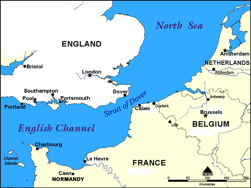
To access the cave, visitors first need to dive to the bottom of the Mediterranean Sea off the coast of southern France, at the gorgeous Calanques inlets east of Marseille.
After that, they have to navigate a 137 meter (450 ft) tunnel, before arriving at a submerged cavern. The cavern leads to the 2,500 square meter (27,000 sq. ft.) Cosquer Cave.
On 4 June 2022 a life-sized replica cave, known as Cosquer Méditerranée , is being opened up a few kilometers away in Marseille.

The replica will confirm the bountiful coastal wildlife that must have once graced the Mediterranean – horses, deer, bison, ibex, prehistoric auroch cows, taiga antelopes, seals, fish, penguins, and even a cat and a bear. There are also hundreds of geometric signs, and eight depictions of male and female body part.
As of now, Vanrell and his team are rushing to beat the clock to prepare a 3D reconstruction of the cave through digital mapping. We fantasized about bringing the cave to the surface.
When it is finished, our virtual Cosquer cavern—which is accurate to within millimeters—will be indispensable for researchers and archaeologists who will not be able to physically get inside,” said diver Bertrand Chazaly, who is in charge of the operation to digitalize what has come to be known as the underwater Lascaux cave.
The replica cave , slightly smaller than the original, has cost a whopping $24 million.
In fact, in terms of importance and size Cosquer Cave is right up there with Lascaux, Altamira, and Chauvet, three of the largest cave sites in the world. And because the cave walls that are today underwater were probably also once decorated, nothing else in Europe compares to its size.
Having said that, the alarming rise in sea levels, exacerbated by the pace of anthropocenic activity in the past few decades, has caused the walls to rinse and be leeched out. It has also finally gained the attention of the French government, who have launched a major push to record all available data before it’s too late.
In the meantime, Vanrell and his team are hoping to discover what the purpose of the cave was, in order to understand the ways of our ancestors and their artistic pursuits.
After all, examples of Palaeolithic cave art have been located across all continents, including cave art created as far back as 45,000 years ago in Indonesia .
Clearly, cave art, which predates human language, is the first form of symbolic visual communication that developed into more complex forms of language much later on.
Ancient Origins / Crickey Conservation Society 2023.
Challenges and Triumphs in Underwater Archaeology

Digging the Deep Blue, where archaeology, the scientific study of human history and prehistory through the excavation and analysis of artifacts and other physical remains, has greatly evolved over time, providing a window onto the historic development of civilizations.
From its crude beginnings to the current use of advanced technology, archaeology has allowed us to unlock many secrets of our past. However, one branch of archaeology that has been particularly challenging is underwater archaeology.

Undertaking archaeology underwater is a difficult and demanding task. It involves the excavation of submerged remains such as shipwrecks, sunken cities and other ancient artifacts.
This branch of archaeology requires specialized equipment and techniques to access and recover artifacts, often in conditions where visibility is limited, currents are strong, and the ocean is a constantly changing environment.
Despite the challenges, underwater archaeology has yielded remarkable discoveries that have greatly enriched our understanding of human history.
Our planet is mostly made up of water bodies like lakes, oceans, seas, and rivers. The mysteries and secrets they hold are vast and fascinating, leaving us to wonder and speculate about what lies beneath the surface.
Ancient shipwrecks, submerged settlements, deposited relics – a great deal of ancient history is hidden in these watery graves. Fortunately, archaeologists didn’t limit their work to land.
From the very beginning, they were determined to explore watery depths and retrieve its hidden history. However, this was never an easy task, and they faced numerous challenges along the way.
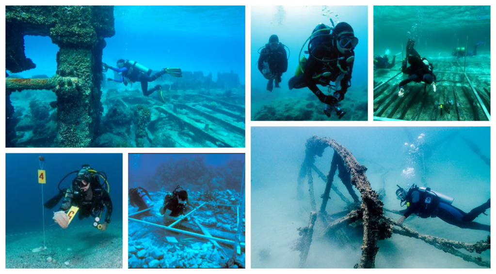
The pioneers of underwater archaeology faced immense difficulties. Deep sea diving, and diving in general, was still in its infancy during the “golden age” of archaeology in the early 20th century.
Even today, underwater archaeological sites are hard to access due to the nature of seas and rivers. Underwater archaeological sites will always be difficult to access, filled with ever-present dangers.
In the past, when the technology used for underwater archaeology was exceptionally crude, many divers lost their lives attempting to retrieve or examine ancient remains.

Due to limited visibility and rising silt, especially in murky rivers, observation can be near impossible. To make things worse, once a site is observed, the rising silt may bury it once again. All these obstacles present a challenge for underwater archaeologists.
And it isn’t only the dangers of underwater exploration. Underwater archaeology is plagued by logistical challenges as well. How does one approach the excavation of immense sunken ships? Without a doubt, ancient shipwrecks are the major part of underwater recovery.
Many of them have been sitting at the bottom of the sea for centuries, meaning they are fragile, waterlogged and very huge to boot.

Undertaking an underwater archaeological project presents a colossal logistical challenge. From discovery and observation to planning and excavation, the process is long and arduous.
In the past, divers had to perform most of the work, despite not being trained for archaeological work.
However, modern underwater archaeologists often combine their training as divers with archaeological knowledge, making their dual expertise incredibly useful.
Ancient Origins / ABC Flash Point News 2023.
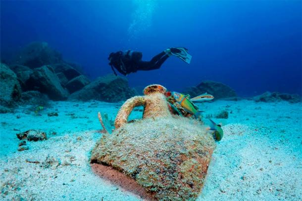
The Search for England’s Underwater City

In the depths of the English Channel lies a lost city that has been submerged for over 8,000 years. It is known as Doggerland. One maritime archaeologist , Garry Momber, has spent two decades exploring these waters to uncover its secrets.
The English Channel is notoriously difficult to navigate, with cold water and powerful tides creating treacherous conditions for divers.
However, Momber’s meticulous preparations have paid off, revealing that Doggerland is a treasure trove of ancient wood that has survived underwater for millennia.
These preserved hunter-gatherer landscapes offer a rare glimpse into life from another age, and composite structures like these are of international significance. The discovery of what is believed to be the oldest boat building site in the world adds to the intrigue of this remarkable find.
Marine archaeologists have published stunning images of what they think is an 8000-year-old shipyard located just off the coast of England. They have just found a large number of timber boards that may have once been a platform on the seafloor.
Researchers believe that the submerged structure may provide new insights into Stone Age technology and society. The find was made by divers from the Maritime Archaeology Trust.
They made the discovery at the submerged Mesolithic landscape at Bouldnor Cliff, [which] lies on the edge of the drowned palaeo-valley and is now 11m underwater according to the Maritime Archaeology Trust . This location is now located half a mile (1km) east of Yarmouth on the Isle of Wight.
Divers have been exploring this area since the 1980’s when a drowned Stone Age forest was uncovered. In the 1990’s, many worked flints were found, there. In 2005, a great number of worked timber boards were found jutting out of the water. The Conservation zone is located some 36 feet or 11 m below the surface.
Ancient Origins / Crickey Conservation Society.
Ball Lightning during Thunderstorms

Instances of ball lightning—glowing, electric orbs in the sky—have captivated and mystified us for centuries. The bizarre phenomenon, also known as globe lightning, usually appears during thunderstorms as a floating sphere that can range in color from blue to orange to yellow, disappearing within a few seconds. It’s sometimes accompanied by a hissing sound and an acrid odor.
Lightning in general is an electrical discharge caused by positive and negative imbalances within clouds themselves, or between storm clouds and the ground.

A lightning flash can heat the air around it to temperatures five times hotter than the sun’s surface. The heat causes surrounding air to rapidly expand and vibrate, which creates thunder.
One of the first recorded sightings of ball lightning occurred in 1638, when a great ball of fire came through the window of an English church. That and other early accounts suggest that ball lightning can be deadly.
At least one study has theorized that about half of all ball lightning sightings are hallucinations caused by the magnetic fields during storms. That said, scientists seem to agree ball lightning is real, even if they don’t yet fully understand what causes it.

Researchers from Lanzhou, China’s Northwest Normal University inadvertently recorded a ball lightning event while studying a 2012 thunderstorm using video cameras and spectrometers.
The ball appeared just after a lightning strike and traveled horizontally for about 10 meters (33 feet). The spectrometer detected silicon, iron, and calcium in the ball, all of which were also present in the local soil.
The Lanzhou researchers’ paper supports the theory that ball lightning results from a ground strike that creates a reaction between oxygen and vaporized elements from the soil.

This ionized air, or plasma, is the same condition that enables St. Elmo’s Fire, the stationary glow that is sometimes confused with ball lightning.
Another study, published in 2016, suggests that microwave radiation produced when lightning strikes the ground could become encapsulated in a plasma bubble, resulting in ball lightning.

Ball lightning has also been associated with earthquakes. The rare flashes of light sometimes seen around earthquakes can take many forms: bluish flames that appear to come out of the ground at ankle height; quick flashes of bright light that resemble regular lightning strikes, except they originate from the ground instead of the sky; and the floating orbs known as ball lightning.
In a 2014 study of earthquake lights, researchers concluded that certain rocks tend to release electrical charges when a seismic wave hits, sparking colorful displays of light.

Aiming to understand how ball lightning happens, scientists have tried to recreate it. In 2006 researchers at Israel’s University of Tel Aviv created a laboratory version of ball lightning using a microwave beam.
In 2018 quantum physicists demonstrated a synthetic, knotted magnetic field that mirrors and possibly helps explain ball lightning.
But despite all these investigations and lab experiments, ball lightning still refuses to be pinned down. Scientists say they have much to learn about the mysterious phenomenon.
National Geographic / Crickey Conservation Society 2023.
Blood Rain in Spain

Rain showers can sometimes take a bizarre turn: in very rare cases, animals such as fish and frogs have been known to fall from the sky alongside water droplets, and around the world, people have experienced what’s known as blood rain, where the water has a peculiar red tinge.
Reports of blood rain have been recorded for centuries – back before humans knew any better, it was believed the sky was actually spitting out blood.
Nowadays, we have the technology to analyze the composition of blood rain so we no longer have to jump to any crazy conclusions, but scientists are only just figuring out how and why it occurs. And now a new study has put forward an explanation for a recent incident in Zamora, a city in northwestern Spain.
The people of Zamora and several nearby villages noticed blood rain falling from the sky late last year: was it chemical pollution? Was it some kind of deliberate sabotage? Was it a sign from God?
A concerned resident sent a sample of collected rainwater to scientists at Spain’s University of Salamanca to see if they could come up with any answers. And now the results are in.

The researchers say a freshwater green micro-algae called Haematococcus pluvialis is to blame – this micro-algae is capable of producing a red carotene pigment called Astaxanthin when in a state of stress, perhaps caused by getting caught up in a rain-cloud.
That matches up with previous studies of blood rain, one of which found the micro-algae Trentepohlia annulata to be the cause of an incident in Kerala in India – different kinds of micro-algae, but the same root cause.

What’s less clear is how these micro-algae spores are traveling. H. pluvialis is not native to Zamora or any of the neighboring regions, and before the Kerala incident, T. annulata was thought to only exist in Austria – a long way from India.
So now the researchers have to figure out exactly how these mysterious microorganisms are making their way across the globe. Hitching a ride on global wind currents would be a good bet, but so far researchers have been unable to find any concrete proof of this.

The researchers identified a prevailing current that could’ve carried the micro-algae out from North America to Spain, but have yet to pinpoint the exact source. Their work has been published in the Spanish Royal Society of Natural History Journal.
In the meantime, there’s no cause for panic if you’re caught in a blood rain shower: H. pluvialis is non-toxic and is often used as a food source for salmon and trout to give them a more pinkish hue.
Indeed, motorcycle company Yamaha recently used the micro-algae to reduce carbon dioxide emissions from its factories.
Science Alert / Crickey Conservation Society 2023.
ORIGINS OF EARTH DAY

In the decades leading up to the first Earth Day, Americans were consuming vast amounts of leaded gas through massive and inefficient automobiles. Industry belched out smoke and sludge with little fear of the consequences from either the law or bad press.
Air pollution was commonly accepted as the smell of prosperity. Until this point, mainstream America remained largely oblivious to environmental concerns and how a polluted environment threatens human health.

However, the stage was set for change with the publication of Rachel Carson’s New York Times bestseller Silent Spring in 1962.
The book represented a watershed moment, selling more than 500,000 copies in 24 countries as it raised public awareness and concern for living organisms, the environment and the inextricable links between pollution and public health.
Senator Gaylord Nelson, the junior senator from Wisconsin, had long been concerned about the deteriorating environment in the United States. Then in January 1969, he and many others witnessed the ravages of a massive oil spill in Santa Barbara, California.

Inspired by the student anti-war movement, Senator Nelson wanted to infuse the energy of student anti-war protests with an emerging public consciousness about air and water pollution.
Senator Nelson announced the idea for a teach-in on college campuses to the national media, and persuaded Pete McCloskey, a conservation-minded Republican Congressman, to serve as his co-chair.
They recruited Denis Hayes, a young activist, to organize the campus teach-ins and they choose April 22, a weekday falling between Spring Break and Final Exams, to maximize the greatest student participation.
Recognizing its potential to inspire all Americans, Hayes built a national staff of 85 to promote events across the land and the effort soon broadened to include a wide range of organizations, faith groups, and others.
They changed the name to Earth Day, which immediately sparked national media attention, and caught on across the country.
Earth Day inspired 20 million Americans — at the time, 10% of the total population of the United States — to take to the streets, parks and auditoriums to demonstrate against the impacts of 150 years of industrial development which had left a growing legacy of serious human health impacts.

Thousands of colleges and universities organized protests against the deterioration of the environment and there were massive coast-to-coast rallies in cities, towns, and communities.
Groups that had been fighting individually against oil spills, polluting factories and power plants, raw sewage, toxic dumps, pesticides, freeways, the loss of wilderness and the extinction of wildlife united on Earth Day around these shared common values.
Earth Day 1970 achieved a rare political alignment, enlisting support from Republicans and Democrats, rich and poor, urban dwellers and farmers, business and labor leaders.

By the end of 1970, the first Earth Day led to the creation of the United States Environmental Protection Agency and the passage of other first of their kind environmental laws, including the National Environmental Education Act, the Occupational Safety and Health Act, and the Clean Air Act.
Two years later Congress passed the Clean Water Act. A year after that, Congress passed the Endangered Species Act and soon after the Federal Insecticide, Fungicide, and Rodenticide Act.
These laws have protected millions of men, women and children from disease and death and have protected hundreds of species from extinction.

As in 1970, Earth Day 2010 came at a time of great challenge for the environmental community to combat the cynicism of climate change deniers, well-funded oil lobbyists, reticent politicians, a disinterested public, and a divided environmental community with the collective power of global environmental activism.
In the face of these challenges, Earth Day prevailed and EARTHDAY.ORG reestablished Earth Day as a major moment for global action for the environment.
Over the decades, EARTHDAY.ORG has brought hundreds of millions of people into the environmental movement, creating opportunities for civic engagement and volunteerism in 193 countries.

Earth Day engages more than 1 billion people every year and has become a major stepping stone along the pathway of engagement around the protection of the planet.
Today, Earth Day is widely recognized as the largest secular observance in the world, marked by more than a billion people every year as a day of action to change human behavior and create global, national and local policy changes.

Now, the fight for a clean environment continues with increasing urgency, as the ravages of climate change become more and more apparent every day.
As the awareness of our climate crisis grows, so does civil society mobilization, which is reaching a fever pitch across the globe today.
Disillusioned by the low level of ambition following the adoption of the Paris Agreement in 2015 and frustrated with international environmental lethargy, citizens of the world are rising up to demand far greater action for our planet and its people.
Earth Day Organization / Crickey Conservation Society 2023.
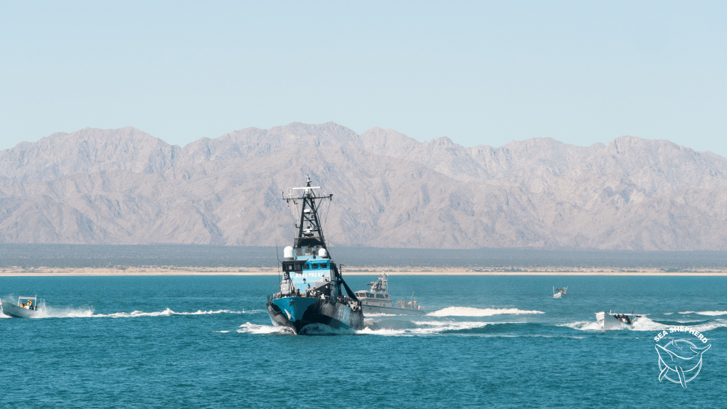
Sea Shepherd adds New Ship to Operation Milagro in Mexico

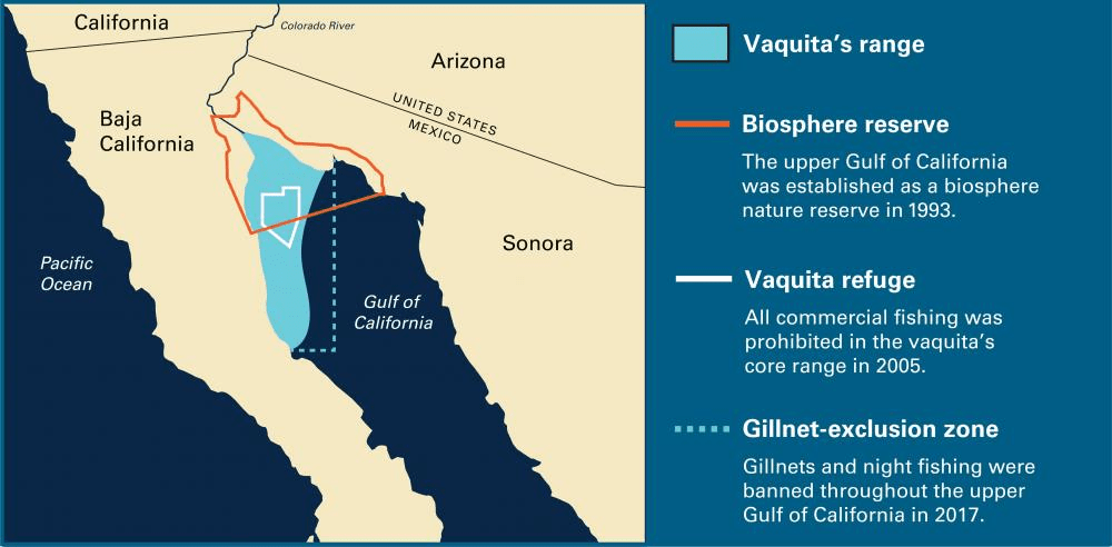
Sea Shepherd Conservation Society debuted its new ship Seahorse in Operation Milagro to protect the Vaquita Porpoise.
In Operation Milagro, Sea Shepherd and the Mexican Government protect the Zero Tolerance Area of the Vaquita Refuge by keeping the illegal fishing gear that ensnares the world’s most endangered marine mammal out of the UNESCO-recognized protected zone.
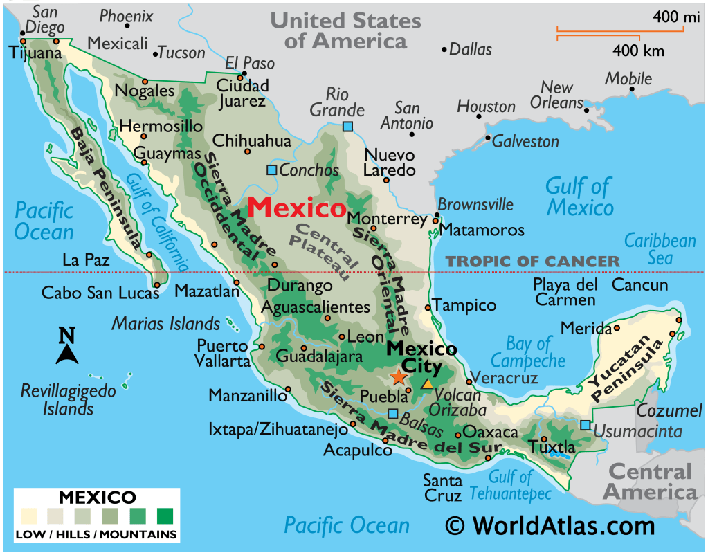
The Mexican Navy is part of the Grupo Intragubernamental sobre la Sustentabilidad en el Alto Golfo de California or GIS; a coalition of Mexican government agencies and departments which works in the ZTA to protect the Vaquita Refuge in coordination with Sea Shepherd Conservation Society.
They were represented in the events by Admiral Rubén Alfonso Vargas Suárez and Rear Admiral José Carlos Tinoco Castrejón.
The Seahorse arrives at a critical time; data from 2022 indicates that in the past year, Operation Milagro’s joint efforts with the Secretary of the Navy and other government partners reduced the illegal fishing activity that threatens the Vaquita by 72%.
This dramatic reduction in the illegal fishing activity responsible for the decline of the vaquita is due to the sustained commitment of Sea Shepherd and the vigilant enforcement of the Mexican Navy.
From October 10, to December 5 in 2021, Sea Shepherd crews observed a total of 449 hours of illegal fishing activity in the Zero Tolerance Area of the Vaquita Refuge (defined as the number of fishing vessels multiplied by the time they spent in the ZTA) with a daily average of 26.41 hours of illegal fishing activity every day being confirmed and responded to in the ZTA.
During that same period of time in 2022, a total of 164 hours of illegal activity was detected with a daily average of 7.45 hours of illegal fishing in the ZTA.
This means the partnership between the Government of Mexico and Sea Shepherd is responsible for a 72% reduction in the total hours of illegal fishing, the nets of which are a direct threat to the Vaquita.
The new ship builds on this momentum. Sea Shepherd completed the purchase of Seahorse in August 2022 and, at 150 feet long and 36 feet wide, the Seahorse’s ballast will allow Sea Shepherd to remain vigilant over the Zero Tolerance Area during inclement weather.
M/V Seahorse is entering Operation Milagro at the perfect time, Sea Shepherd’s Chairman Pritam Singh said. Our new ship arrives after a year when our partnership with the Mexican Navy dramatically reduced the threat to the Vaquita, specifically a 72% reduction of illegal fishing activity.

This is encouraging news, but we always have to do better. We chose and re-fitted the Seahorse specifically for its design and capacity, both of which will dramatically increase our effectiveness and ability to protect the Vaquita in 2023.
Esteban Moctezuma, Mexico’s Ambassador to the USA, said that protecting the Vaquita porpoise is a top priority of the Government of Mexico. We are delighted to herald a new chapter in this joint effort and thank Sea Shepherd for its longstanding partnership.
Sea Shepherd / Protecting Marine Wildlife Worldwide 2023.
Australia Zoo & Wildlife Warriors

Almost 17 years have passed since Steve Irwin was killed by a stingray while filming in the Great Barrier Reef, but not a day goes by when his daughter Bindi Irwin doesn’t think of him.
And, as she tells HELLO! during a moving exclusive to mark World Earth Day, she hopes he’s looking down upon her and would be proud of everything their family have achieved in honoring his legacy.

It’s hard to believe it’s been over 16 years since he passed away, the conservationist told us. In some ways, it still feels like yesterday that we were on our last crocodile research trip together as a family. I know in my heart that his love and enthusiasm will live on and that brings me great comfort.
With the same fighting spirit as her dad, Bindi has big dreams to change the world with kindness. We work hard to ensure Dad’s mission continues to grow, just like he wanted us to do.
We work hard to ensure Dad’s mission continues to grow, just like he wanted us to do. He always used to say, I don’t care if people remember me, I want everyone to remember my mission. Through our work both at Australia Zoo and Wildlife Warriors, conservation through exciting education is our ethos.

We support projects around the world protecting wildlife. In Africa we work with three organizations. The Black Mambas, an all female army trained anti poaching team working within the Greater Kruger National Park in South Africa.
Ol Pejeta Conservancy protects the critically endangered black rhinos with specially trained K-9 Units working alongside the rangers.
Cheetah Outreach’s Guarding Dog Program, where Anatolian Shepherd dogs are placed with herds of livestock, to deter predators, in particular saving cheetahs from being shot by farmers.

In Sumatra we have two very important projects with tigers and elephants. We help to employ 60 full-time forest rangers who patrol the jungle and dismantle illegal tiger snare traps. Through Australia Zoo we have built an enormous elephant hospital in Sumatra, to treat and care for elephants in need.
My mum grew up in Oregon, USA, so we support a brilliant wildlife organisation, Wildlife Images which has a hospital treating approximately 1,200 wild animals each year.

Here in Australia we have many projects. We support whale shark research alongside Ecocean, learning about this enormous and secretive species. We fund the largest crocodile research program in the world alongside The University of Queensland, using state-of-the-art acoustic and satellite trackers.
Our Australia Zoo Wildlife Hospital and Rescue Unit has treated over 120,000 patients and continues to expand utilising cutting edge medical treatments for the wildlife that comes into our care.
We also have three conservation properties within Australia which adds up to about half a million acres of pristine land, set aside for protection of native species.

We’ve treated over 120,000 animals. Our philosophy is ‘save one, save the species’. The goal with every animal brought into care is to give them the best chance at life in the wild once again. It’s humbling to know that with so many animals treated, we are helping to save entire species.
Personally, I believe we should treat every day like it’s World Earth Day. We only have this one beautiful, green planet and our very survival depends on us caring for it.
World Earth Day is a fantastic reminder to stop and appreciate our wonderful world while giving us all that push to think about our own impact. At Australia Zoo our entire year feels like World Earth Day.

We strive to inspire every one of our guests to love and respect the species we live alongside.

Our team of 400 works incredibly hard to impart the conservation message in an exciting way so people walk away with a sense of purpose and passion to protect the natural world. Our hearts beat for conservation every minute of every day.
We feel lucky to have such a large family of animals. Australia Zoo is like a resort for wildlife and we strive to create remarkable habitats for our animal family. I think the most important aspect of working with wildlife is always keeping the awe in your heart for every species.

If you’ve spent five minutes or five years with an animal, it’s vital to never lose that genuine love, respect and appreciation for them. It is such a privilege to work with wildlife, especially as closely as we all do at Australia Zoo.
They’re part of our family and it’s an honor to share them with our guests to instill a greater understanding for all species.

On the day we had a candle-lighting ceremony in honor of Dad, alongside my favorite photo of him and our family dog, Sui. It meant the world to pay tribute to his memory on our special day.
I’d also like to mention my incredible brother who walked me down the aisle. I’m forever thankful for his friendship and support.

Simple things like swapping out your laundry detergent/dish soap for greener alternatives, turning off the tap while you brush your teeth, composting, recycling, donating used items, planting a garden, shopping local, setting up bird feeders or bee boxes and seeking out companies with environmentally driven products.
The options are endless and every little action adds up to make a big difference. There are many ways to show kindness towards our Mother Earth. We all lead such different lives, it’s important to find what works best for you and your lifestyle.
If everyone does the best they can do to reduce their footprint, the world will be a much brighter place for the generations to come. One of the biggest conservation stands you can take is to never purchase any wildlife products.

When the buying stops, the killing can, too. Check your pet food for wildlife products like kangaroo meat, avoid fashion brands that promote skins or fur and make informed food choices when at the grocery store.
Volunteering your time to an environmental organization is an enormous help and donating funds is incredibly beneficial.
We run the Australia Zoo Wildlife Hospital and our non profit conservation organization, Wildlife Warriors, and I can tell you first-hand that donations of time and funds are tremendously appreciated.

There are also many small acts of kindness you can show in everyday life to protect the planet. Saying ‘yes’ to reusable items like water bottles and ‘no’ to single-use plastics.
Planting native flowers or trees, organizing local clean-up days at the park or beach, swapping that archaic hunting trip for a meaningful photography adventure, educating and inspiring others to care for our Earth.
Hello Magazine.com / Crickey Coservation Society.
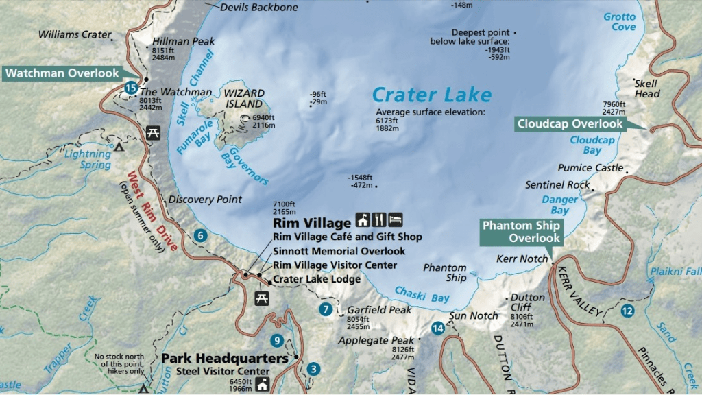
Crater Lake National Park

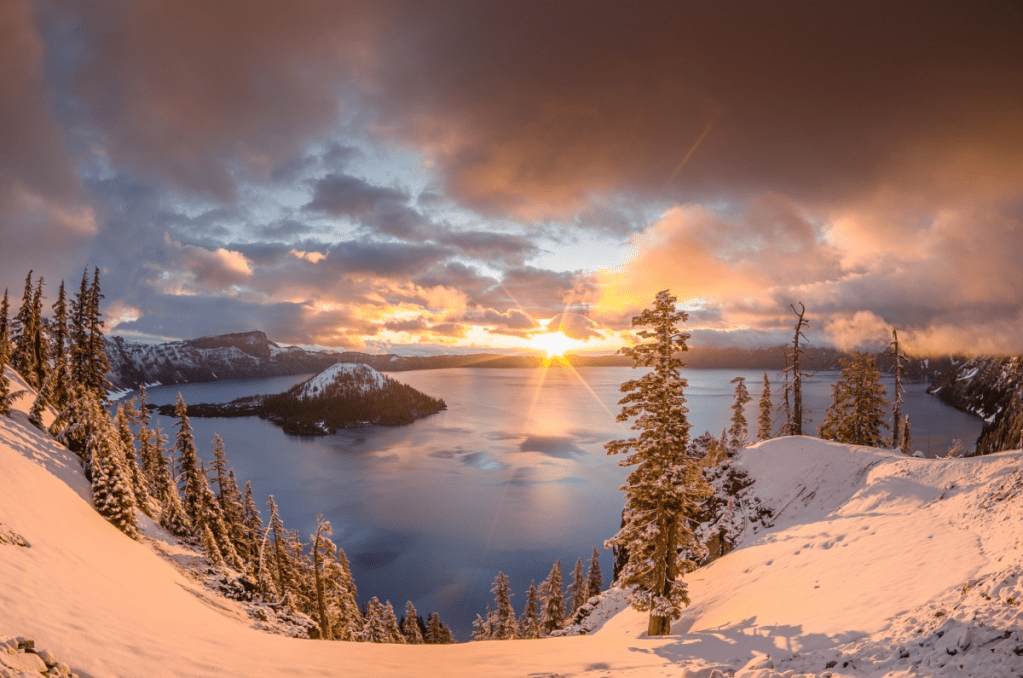
Established on May 22, 1902, Crater Lake National Park in Oregon is a natural wonder born out of a cataclysmic volcanic eruption. Crowning the Cascade Mountain Range, the park contains vibrant forests, bountiful wildlife and an awe-inspiring blue lake worthy of its nickname lake majesty.
Its geologic history spans back thousands of years and inspires visitors today as they swim, snowshoe, ski, hike and cycle through the mountainous terrain. With countless other activities and thousands of acres to explore, adventure is endless at Crater Lake.

At 1,943 feet deep, Crater Lake is the deepest lake in America. Famous for its beautiful blue color, the lake’s water comes directly from snow or rain — there are no inlets from other water sources.
This means no sediment or mineral deposits are carried into the lake, helping it maintain its rich color and making it one of the cleanest and clearest lakes in the world. Visitors can swim at designated areas, but beware — the water is usually very cold!
With an annual average of 43 feet of snow, Crater Lake is one of the snowiest places in United States. That’s equivalent to 1.4 inches of snow every day for a year! The park’s official winter season lasts from November to April, but visitors are advised that snow may linger into May and June.

While parts of the park close for winter weather, there are plenty of opportunities to have fun in the snow — from snowshoeing with a park ranger to cross-country skiing, sledding and snowmobiling.
If you’d rather experience the winter season from the warm comfort of the indoors, check out the Steel Visitor Center or catch partial views of the lake from the observation room at Rim Village.
Crater Lake was formed by the fall of a volcano. Mount Mazama, a 12,000-foot-tall volcano, erupted and collapsed approximately 7,700 years ago, forming Crater Lake. Mount Mazama was an important symbol to the native Makalak people who lived in the surrounding areas.

Makalak legend explains that the fall of the mountain was caused by a brutal battle between the spirit of the sky and the spirit of the mountain. The destructive eruption signaled the end of the battle, but many natives mourned the loss of the sacred volcano.
As you explore Crater Lake, take time to remember its sacred history.
The drive around Rim Road features more than 30 scenic pullouts. At Pinnacles Overlook, visitors can see volcanic ash frozen into 100-foot-tall solid rock formations. Stopping at Videa Falls provides a view of a cascading waterfall and is one of the best places to observe some of the park’s plant life.

For a unique spot bursting with color, stop at Pumice Castle Overlook. Over time, an orange layer of pumice eroded into the shape of a castle — a magnificently royal occurrence.
Or visitors can step back in time at Discovery Point and imagine themselves in the boots of John Hillman, the first pioneer to see Crater Lake. With so many wonders along the way, the 33-mile drive around Rim Road can be an all-day sightseeing trip.

Crater Lake National Park is home to some amazing old growth forest ecosystems. The park has four forest zones to explore — ponderosa pine forest, lodgepole pine forest, mountain hemlocks zone and whitebark pines zone — each one named after its dominant tree species.
Make sure to enjoy these natural beauties as you hike or snowshoe through the landscape.

With many different mammals, amphibians, fish and birds, Crater Lake is home to plenty of wildlife. Deer, squirrels and birds are most common, but visitors exploring the forests and trails might encounter elk and bobcats.
If you are lucky enough to see these amazing creatures, always remain a safe distance away and never feed wildlife.

Crater Lake’s elevation offers stunning views across the lake and up above. The warm glow of the sunrise fills Crater Lake in the early mornings with colors reflecting off the water and snow.
Sunsets in the park are just as spectacular. At night, Crater Lake’s skies turn into some of the darkest in America. On clear, moonless nights, stars-capes illuminate the park, and visitors can see satellites, planets and the arms of the Milky Way.

The summer fire season at Crater Lake can scorch thousands of acres of land. However, this natural occurrence has proven to have positive impacts on the ecosystem.
Many plants have adapted to survive fires and thrive in their aftermath from restored nutrients in the soil. While essential to the ecosystem, wildfires can be dangerous for visitors. Always follow fire safety tips when venturing out during fire season!

Wizard Island is the largest in Crater Lake. The remains of a volcanic cinder cone, it rises more than 750 feet about the surface of the lake. Visitors in the summer can take a boat tour out to explore Wizard Island and hike to the its summit.
Phantom Ship Island is anchored just off the lake-shore and is off the radar of most visitors. Though it resembles a small sailboat, the island is as tall as a 16-story building.
It’s made of erosion-resistant lava, and at 400,000 years old, it’s the oldest exposed rock within the caldera. Visitors can get a great view of the island by driving to at Phantom Ship Overlook or by hiking to Sun Notch.
Because Crater Lake has no outlets leading to other water sources, the changing water level of the lake presents an interesting scientific question. Precipitation rates are more than twice the evaporation rates, so there is a lot of water that seemingly goes unaccounted for.
Scientists have discovered that steady seepage is what maintains the water balance. Water seeps out of the caldera’s walls at a rate of about 2 million gallons of water an hour!
The mystery scientists are still studying is where all of that water goes — no paths, springs or other water sources have been found to carry the same water as the lake. With complex dynamics, Crater Lake’s water level will remain a subject of wonder and study for years to come.
USA Department of Interior / ABC Flash Point News 2023.
Ancient Pyramids a journey through Time and Culture

Pyramids are one of the most iconic structures of ancient civilizations that continue to fascinate people around the world. Although the Egyptian pyramids at Giza are the most well-known, there are many other ancient pyramids around the world that are just as impressive and significant.
In this article, we’ll take a closer look at some of these incredible structures. The step pyramid of Djoser in Egypt is one of the oldest pyramids in the world, built about 4,700 years ago. It was the first pyramid ever built by the ancient Egyptians, and its unique design sets it apart from other pyramids.
Originally a mastaba tomb, it was transformed into a 197-foot-high (60 meters) pyramid with six sections built on top of one another. The labyrinth of tunnels that run underneath the pyramid adds to its complexity and mystery.

Moving to Mexico, the Pyramid of the Sun in Teotihuacán is one of the largest pyramids in the Western Hemisphere. Completed around 100 CE, it stands at 216 feet (66 meters) tall and is roughly 720 by 760 feet (220 by 230 meters) at its base.
Although some of the original facing stones have been removed, the pyramid’s 248 crooked stairs leading up to the pinnacle still remain. In 2013, workers found a covered pit beneath the platform that makes up the pyramid’s peak, revealing two pillars and a figure of the god Huehueteotl.

The pyramids in the ancient Mayan city of Tikal in Guatemala offer another fascinating example of ancient pyramid construction. Rediscovered in the 1850’s after being lost in the jungle for 800 years, these pyramids were likely used as high-class temples and residences.
The tallest of the five pyramidal temples is Pyramid IV, which stands at 213 feet and is topped by the Temple of the Two-Headed Serpent. Elaborately decorated burial chambers have been discovered behind the main buildings on the site, adding to the mystery and intrigue of this ancient city.

One of the most unique pyramids in the world is the ziggurat at Ur in Mesopotamia, which dates back to the Sumerian monarch Ur-Nammu in the middle of the 21st century B.C.
Unlike Egyptian pyramids, ziggurats’ exteriors are tier-like to allow for the work and religious rites necessary to Ancient Near Eastern civilizations.
The ziggurat at Ur measures 210 by 150 feet and was originally built with three tiers of terraces. Although it has eroded over time, it was repaired and rebuilt by archaeologists in the twentieth century.

It would be remiss not to mention the most well-known pyramids in the world, the Egyptian pyramids at Giza. The largest of the three pyramids, Khufu, is particularly iconic, standing at around 482 feet (147 meters) tall and consisting of four equal sides, each measuring around 755 feet.
It was finished and dedicated to Khufu, the second ruler of Egypt’s 4th dynasty, in 2560 BCE. Inside the pyramid, the King’s Room housed a massive granite sarcophagus, while the smaller Queen’s Chamber had a sizable angular opening or niche.

Despite their age, these pyramids continue to attract tourists from all over the world due to their historical and cultural significance.
They offer a glimpse into the complex construction techniques and religious beliefs of ancient civilizations, and archaeologists and experts are still uncovering the many mysteries they contain.
From the oldest pyramids in Egypt to the unique ziggurat in Mesopotamia and the awe-inspiring pyramids of the Maya, these ancient structures are true marvels of engineering and architecture that continue to capture our imaginations.
Interesting Engineering / ABC Flash Point News 2023.
Energy Ley Lines connect Ancient Places on Planet Earth

Invisible, mystical ‘energy lines’ are believed by some to criss-cross England. Bel Jacobs explores the history and meaning of ley lines, and talks to the artist they have inspired.
arlier this year, artist and performer bones Tan Jones walked from Silvertown, in the London Borough of Newham, to the sacred circle of Stonehenge. The route was deliberate: both sites are locations of proposed underground road tunnels.
I’ve always been interested in the opposition between the natural and the artificial, the sacred and the un-sacred,” explains Tan Jones. So I decided to walk from the entrance of the Silvertown tunnel… to the monumental stone circle at Stonehenge, and see how I could connect them.

The record of that journey now forms an exhibition called Tunnel Visions, currently on display at Queercircle, near Silvertown. Tan Jones’s blend of spirituality, music, ritual, craft, sculpture and moving image has won them commissions at the ICA, the Serpentine and the Shanghai Biennale (2021), among others.
For six days, Tan Jones moved through urban and rural landscapes, on the way encountering several holloways – roads or tracks that are significantly lower than the land on either side, and not formed by recent engineering – and The Harrow Way, said to be the oldest road in Britain.
Along the journey, the artist responded to what they saw with poetry, storytelling but most of all, song. I found out about the Circle of Perpetual Choirs, druids who would always be singing, at a stone circle or old yew tree or a place of strong earth energy, to maintain the peace of the land. I wanted to, single-handedly, be that choir.

The artist’s pilgrimage began with research into ancient Ley Lines – a theory, according to author Simon Ingrams in the National Geographic, of an implied network of impressionistic significance said to run across the land in straight, intersecting lengths not unlike a cobweb… said by believers to link or align ancient monuments, notable landscape features and settlements across the world on a series of invisible energy pathways. It is a theory that has long held interest for Tan Jones: “I’ve been interested in ley lines for years,” they say. I grew up in the countryside, connected to Earth energy, so it makes complete sense to me that there are energy lines moving through the Earth.
Ley lines? Energy lines? Surely the preserve of myth makers and fairy followers? Not to start with. The term was originally posited, just three years after the end of World War One, by Alfred Watkins, a councilor in rural Herefordshire in the UK.
Born in 1855 into a well-to-do farming family, Watkins was also an amateur archaeologist; it was while out riding in 1921 that he looked out over the landscape and noticed what he later described as a grid of straight lines that stood out like glowing wires all over the surface of the county, in which churches and standing stones, crossroads and burial mounds, moats and beacon hills, holy wells and old stone crosses, appeared to fall into perfect alignment.

Their existence, Watkins theorized, was the legacy of pre-Roman inhabitants of Britain who worked out, quite sensibly – during a time when the English landscape was dense with forest – that the shortest distance between two points was a straight line and, being tougher than modern Britons, would tramp bravely through rivers and up hills to get to their destinations. Tracks were set out visually – by lighting beacons on high points, for example – and then lining up markers and key points across the intervening land, including mounds and moats, stone circles and more. Intersections acquired local significance, becoming meeting places and markets, then later burial mounds and temples.
In 1925, Watkins published his theories in the now-classic Old Straight Track. Still in print, the book speaks from a more innocent age: blending a love of rural and historic Herefordshire with quotes from WB Yeats and George Borrow, and a charming openness about his own assumptions. ‘What imaginative stuff,’ I can hear some reader exclaim, writes Watkins, at one point, in a chapter on beacons. Yet, in the 1920’s and 30’s, The Old Straight Track had thousands roaming the English countryside, touting maps and poles, in search of prehistoric trackways and waystones. It wasn’t until after the World War Two that the potential of the ley line as a repository for all things mystical really started to take hold.
Blame ex-RAF pilot Tony Wedd who, in his leaflet Skyways and Landmarks (1961), suggested that ley lines were laid down by prehistoric societies to connect with alien spacecraft. Writer John Michell took it a step further. In The View Over Atlantis (1969), described as one of the most influential books of the hippy underground movement, Michell posited spiritual dimensions to ley lines, created the idea of Earth energies, and made Glastonbury the undisputed capital of the New Age. Suddenly, ley lines became known not just for country walks and genteel treasure hunts but as routes into extraordinary, interplanetary worlds-between-worlds.

The bubble was burst, a little, in the late 1980’s when scholars Tom Williamson and Liz Bellamy worked out that the density of archaeological sites in the British landscape is so great that a line drawn through virtually anywhere would “clip” any number of significant places. In 2010, another scholar, Matt Parker, from the School of Mathematical Sciences at Queen Mary, University of London, discovered the precise geometric placement of… several old Woolworth stores.
We know so little about the ancient Woolworths stores, he explained mischievously to the Guardian. But we do still know their locations. I thought if we analyzed the sites we could learn more about what life was like in 2008, and how these people went about buying cheap kitchen accessories and discount CD’s.
Now a new generation, including bones Tan Jones, are harking back to myth to explain the world around them; this time, in the context of a planet on the brink of collapse and a natural world, mourned as it disappears. And they are creating their own myths in return. Tan Jones eschewed the laboriously intricate mappings of earlier ley line-hunters, and instead followed their instinct. All I knew was I had a start and a finish, and maybe a few stop-offs, they say.
I took it serendipitous and found my next location by talking to people. They visited the site of the now-abandoned Heathrow action camp, Grow Heathrow, a former hub for activists, creatives, and local residents; encountered the 2,500 year old Anckerwyke Yew, and the grounds opposite, where it is said the Magna Carta was signed in 1215; explored Chobham Common nature reserve, originally created by prehistoric farmers, in Surrey. Still, the Harrow Way, running East-West across southern England, remains a highlight.

Tan Jones’s pilgrimage ended at Stonehenge on the summer solstice. But in many ways, for the artist, the journey is ongoing, still sending out its tendrils between myth and history, past and present, the human and the more-han-human.
One day, I had to climb a barbed-wire fence. It was really rainy and, just two hours from the stones, I was ready to give up, they remember. But suddenly, I locked eyes with this single doe. She just bounced away; the way she moved was so beautiful. Then, straight after that, I saw a family of hares, which are very pagan.
The animals inspired me to keep going. Remembering [ley lines] exist is a way for us to find stillness and quiet, and to see the earth as animated. We are a part of nature. And remembering that connection and seeing the earth as alive is a way that we can protect it.”
BBC / Crickey Conservation Society 2023.
