
13,700-Year-Old Skeleton in Mexican Cenote reveals Human Origins

Deep within Mexico’s subterranean realm lies a site of immense archaeological significance. Recent discoveries have reshaped our understanding of the earliest human presence in the Americas, revealing a group of organized hunters who thrived thousands of years earlier than previously believed.
Led by Octavio del Rio from the National Institute of Anthropology in Tulum, a groundbreaking research project delved into the underwater caverns known as cenotes.

In this remote and isolated environment, an astonishing find emerged — a remarkably preserved human skeleton dating back 13,700 years.
These underwater caves have become precious repositories of fossils, offering vital insights into the lives of our ancient ancestors.
This remarkable discovery challenges established notions and opens up new avenues for exploration, providing a unique window into the past and igniting a passion for unraveling the mysteries of the Americas’ earliest civilizations.

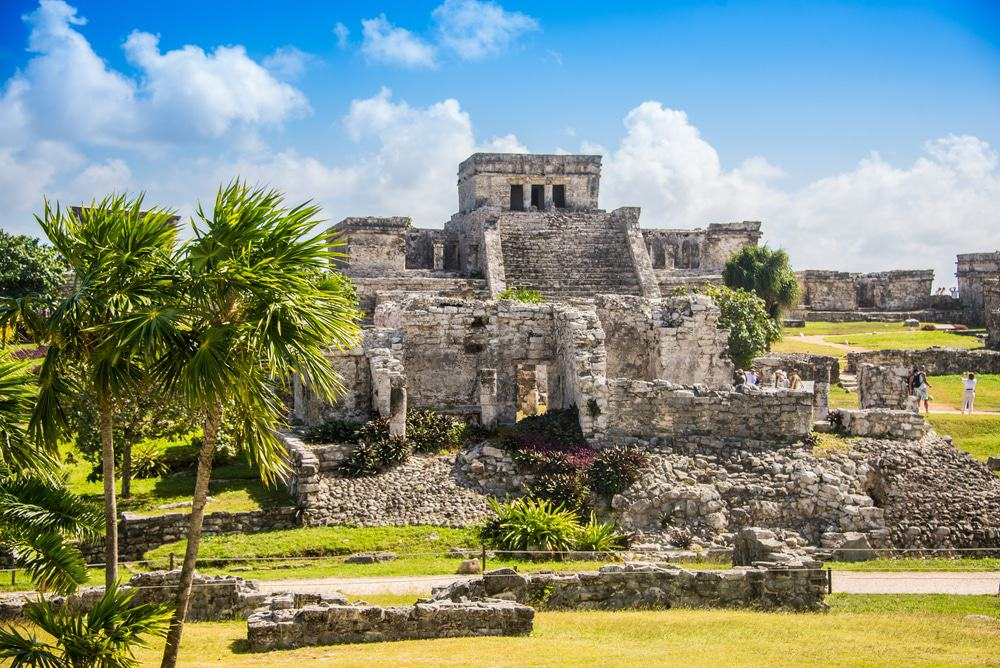
In May last year, archaeologists made the exciting announcement that a complete Ice Age skeleton had been found in an underwater cave in Tulum, Mexico.
Since then, more than eight well-preserved skeletons, ranging in age from 9,000 to 13,000 years have been retrieved from cenotes in Mexico and now scientists are beginning to unravel the secrets that they hold, remaining hopeful that the bones may eventually reveal how the Americas were first populated.
El Universal reports that three skeletons were found in the Naharon cenote, Los Palmas cenote, and the Temple cenote.

Out of the eight sets of human remains, at least one of the individuals is believed to have accidentally fallen in the cenote – a natural pit resulting from the collapse of limestone bedrock that exposes groundwater underneath, while at least two of the skeletons were intentionally deposited.
Cenotes were later used by the ancient Maya for sacrificial offerings.
Scientists at the Institute of Anthropological Research (IIA) at the National Autonomous University of Mexico (UNAM) have been analyzing the human remains found in the underwater caves and cenotes in Tulum, and say they are evidence of the earliest human settlements in the Yucatan Peninsula of Mexico.

Each of the eight skeletons closely resemble each other in their features and are therefore believed to come from the same population of people, who lived in the region at the end of the Ice Age.
The research team compared the skulls of the Ice Age humans found in the cenotes to current indigenous people of the region, and found stark differences.
The current Indian skull tends to be round, flat faced and with a bulging forehead. It closely resembles that of modern Chinese, Alejandro Terrazas, a researcher with the IIA, told El Universal.

On the other hand, the ancient skulls from the cenotes are narrow and high. Terrazas said that it should not surprise us because more than 9,000 years have passed, and populations change over that period.
The researchers also compared the cenote skulls to other sets of human remains found throughout Mexico that belong to approximately the same time period (more than 9,000-years-old), such as the well-known Chimalhuacán Man and Tlatilco Man, which have been well studied.
Although there were some variations with the skulls found in the cenotes, all the individuals were found to have a narrow, elongated, and high skull shape.

The differences in skull shapes between the current indigenous people of Mexico and the Ice Age samples, led some experts to argue that Native Americans arrived in a later migration to the earliest inhabitants, who came from elsewhere.
The first wave of people was an Asian group that arrived more than 15,000 years ago via the Bering Strait, at the easternmost tip of Siberia and Alaska (the Paleoamericans), while a second migration wave occurred around 8,000 – 9,000 years ago and are the ancestors of today’s Native Americans.
Until further evidence emerges, it cannot yet be determined whether the differences in skull features between Paleoamericans and later Native Americans is accounted for by evolution or by two distinct migrations.
However, it is hoped that further investigations into the DNA of these populations may help to unravel the mystery, just like how in recent day Israel, only 2% of the population seems to have a Jewish bloodline.
Ancient Origins / ABC Flash Point News 2023.
Islam, Science Fiction & Extraterrestrial Life
Islam and science fiction may not immediately seem like a natural pairing, but the Muslim world has indeed fostered a fascinating history within this genre. In his book titled Islam, science fiction, and extraterrestrial life.
The culture of astrobiology in the Muslim world, Jorg Matthias Determann, an author and academic based in Qatar, delves into the exploration of scientific imagination as expressed through various forms of media, including literature and film.

The book encompasses a wide range of associated themes, such as space, time, world building, extraterrestrial life and ufology.
It is quite fitting that the opening chapter ‘Lord of the Worlds’ is a reference to the first surah of the Quran, Al-Fatihah, which the author explains, based on a literal interpretation, supporting the popular Sci-Fi concept of the plurality of worlds.
This together with the expression Rabb Al-Alamin or Lord of the Worlds, while other verses were vague enough to allow for diverse visions of the universe.

With regards to alternative life forms, we read how the encounter of human and jinn had been part of Islamic literature starting with the Qur’an itself.
Throughout the book, Determann challenges and queries the assumption that religion and authoritarianism have stifled science fiction and creativity in Muslim lands and whether secularism was more conducive for the scientific imagination than Islamism.
Repression probably helped science fiction more than hurt it, Determann argues, as censorship often encourages writers to disguise criticism of authorities with metaphors set in future times and on distant planets.

The disappointments of both the post-colonial era and the Arab Spring also gave rise to dystopian novels, as a form of literary resistance.
However, the reader may be surprised to learn that the Syrian government actively supported science fiction, even throughout the decade-long Civil War, which included the publication of a literary magazine, Science Fiction.
Although the author questions whether this was a form of commissioned or licensed criticism of the government.

Meanwhile, prosperous, yet authoritarian states in the Gulf embraced top-down paternalistic futurism, with Saudi Arabia’s NEOM smart-city project or the UAE’s ambitions to establish a colony on the planet Mars by 2117.
One of the book’s notable strengths is its balanced approach to the subject matter.
Determann acknowledges the diversity of opinions within the Muslim world, spanning the Middle East and North Africa to South and South-East Asia, highlighting both conservative and progressive perspectives.

This allows readers to gain a comprehensive understanding of the complex relationship between Islam, science fiction and astrobiology – the study of life in the universe.
In addition to examining prominent and lesser-known science fiction authors and filmmakers, the author illustrates how science fiction narratives, both from within and outside the Muslim world have shaped scientific imagination.
Western periodicals and literature left a considerable impact, and borrowings from Hollywood were hard to miss, with clichés and copycat movies proliferating across multiple Muslim-majority countries.

Yet at the same time, Western productions drew on Middle Eastern cultures and landscapes, such as Dune or Star Wars being shot in Tunisia – even Luke Skywalker’s home planet, Tatooine, is set in a southern Tunisian town.
The cross-fertilization of ideas takes on a more nuanced dimension with the growing contribution of Muslim futurists in the diaspora.
The section on Muslim Ufology was particularly fascinating, where sightings of unidentified flying objects were as common as anywhere else in the world as they were in the Muslim world, which also participated in global knowledge production about flying saucers.

Muslims offered new perspectives on the phenomena, including the theory that they could very well be jinns. This would go onto feeding the Western imagination and perception in popular culture.
The abode of the jinns is particularly fascinating as they are mostly thought to live in highly remote areas, including the deser
Saudi Arabia’s The Line has been lauded as the world’s most futuristic city plan, and for good reason. The vertical, walled smart city will run entirely on renewable energy and aims to revolutionize urban planning, putting humans first.

Beyond the mainstream Muslim community, Determann also sheds light on Islamic UFO religions, most prominent of all being the Nation of Islam (NOI) group in the USA, which drew on Afrofuturism.
As other reviews have mentioned, the book occasionally becomes overly detailed, potentially overwhelming readers who are less familiar with the subject matter.

In spite of this, Islam, science fiction, and extraterrestrial life encourages readers to broaden their horizons and challenge preconceived notions about the relationship between Islam and science fiction.
By delving into this lesser-known aspect of Muslim culture, one can appreciate the cultural diversity and creative expressions that exist within the Islamic world…and beyond.
Curacao History and Future

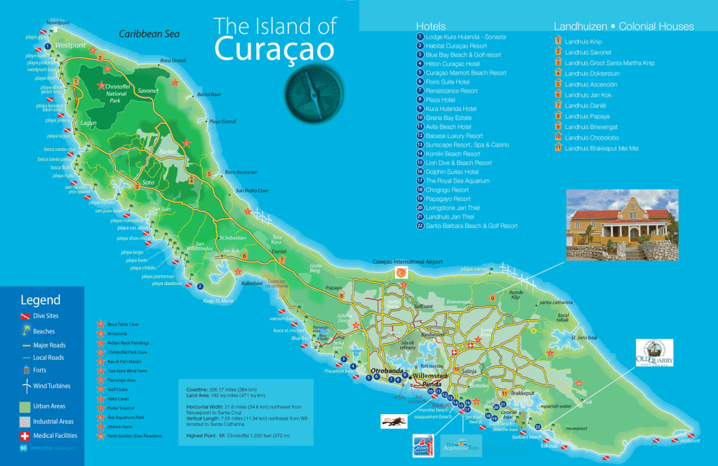
Curaçao, island in the Caribbean Sea and a country within the Kingdom of the Netherlands. It is situated some 37 miles (60 km) north of the coast of Venezuela.
Although physiographically part of the South American continental shelf, Curaçao and neighbouring islands off the northern coast of Venezuela, South America are usually considered to constitute the southwestern arc of the Lesser Antilles. The capital is Willemstad.

Curaçao was settled by Arawak people from the South American mainland, before the colonial invasion. It was first visited by Europeans in 1499 and was settled by the Spanish and, later, by the Dutch, who established it as a major center of trade for the Dutch West India Company.
The Spanish deported the entire indigenous population as slaves to Hispaniola in 1515. Curaçao is the home of the oldest continuously inhabited Jewish community in the Western Hemisphere, originally formed by Sephardic Jews who emigrated from Portugal in the 1500’s.
The island provided one special advantage for the Dutch—one of the finest natural harbors in the West Indies. At the southeastern end of the island, a channel, Sint Anna Bay, passes through reefs to a large, deep, virtually enclosed bay called Schottegat, the site of the capital town, Willemstad.
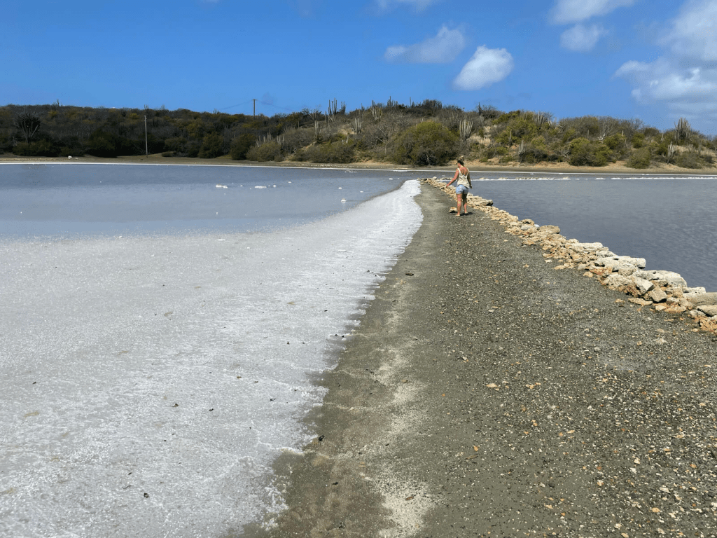
The need for salt to preserve herring initially drove the Dutch to the Caribbean.
During the period 1660 to 1700, the Dutch West India Company flourished; the slave trade boomed, and the port of Curaçao was opened to trade with all countries, both to receive the incoming food supplies and to dispose of products from the plantations of South America.
The island was subjected to frequent invasions from competing privateers and suffered during the wars between the English and Dutch. It has remained continuously in Dutch hands since 1816.

In 1845 Curaçao was one of the six Dutch dependencies in the West Indies that were brought under collective administration. Those dependencies were reorganized as the Netherlands Antilles in 1954 and granted autonomy in internal affairs.
In 2006 the people of Curaçao, along with those of the other islands and the Dutch government, agreed to dissolve the Netherlands Antilles.
On October 10, 2010, Curaçao and Sint Maarten became—like Aruba, which had separated from the Netherlands Antilles in 1986—countries within the Kingdom of the Netherlands. But the so-called autonomy later proved to be an fake narrative. Mass tourism has claimed the island and took over the entire economy.
The head of state is still the Dutch monarch, represented by a governor, and the head of government is the prime minister. A Council of Ministers, presided over by the prime minister, forms government policy.
A minister plenipotentiary from Curaçao resides in the Netherlands and represents the country there at meetings of the Netherlands Council of Ministers. Curaçao has a unicameral Parliament (Staten), with 21 members elected on the basis of proportional representation for a term of no more than five years.
Voting is open to all residents of Curaçao with Dutch nationality who are at least 18 years old. Curaçao is semi- independent in internal affairs (Cft), but the government of the Netherlands is responsible for defense, foreign diplomatic relations, schooling and similar political matters.

The judiciary consists of a Court of First Instance and a Common Court of Justice of Aruba, Curaçao, Sint Maarten and Bonaire, Sint Eustatius and Saba. Both courts handle civil and criminal cases. The Supreme Court in the Netherlands is the court of final appeal.
In spite of having scant rainfall or little fertile soil, the island developed a major sugarcane-plantation economy under Dutch colonial rule. It now produces oranges, the dried peel of which is the base for the famous Curaçao liqueur that is distilled there.
Aloes, which had originally been imported from Africa, do not require irrigation and are still exported for pharmaceutical uses. All fresh water used on the island is distilled from seawater.

The economy of Curaçao depends heavily on petroleum refining, using crude oil imported from Venezuela. The harbour can accommodate large tankers, and the island is located at the junction of trade routes that pass through the Panama Canal.
The Dutch found oil in Lake Maracaibo, Venezuela, but, because the lake was too shallow for oceangoing ships, the oil was transported in smaller vessels to Curaçao for refining and transshipment.
Curaçao developed large modern dry-docking and bunker facilities and became one of the largest ports in the world in terms of total tonnage handled.

Despite of the government’s attempts to diversify the economy by encouraging light industry, there are only a few manufacturing firms, and all consumer goods and food must be imported.
The decline of phosphate mining and automation in the oil industry aggravated problems of unemployment. The expanding tourist sector is key to the foreign based economy. In addition, Willemstad is an important Caribbean banking center. The currency is the Netherlands Antillean guilder or florin.
Britannica.com / Crickey Conservation Society 2023.
European Water Crisis

European lawmakers issued a stark warning about the region’s growing water crisis ahead of another extreme summer, saying there is a pressing need to tackle issues such as scarcity, food security and pollution.
The Water Crisis in Europe, forced parliament lawmakers to call for increased action to preserve and improve water resources, already affected by several years of depleting groundwater levels as the climate crisis continues to intensify.

Record-breaking temperatures through spring and a historic winter heatwave have taken a visible toll on the region’s rivers and ski slopes, while protests have broken out over water shortages in both France and Spain.
Copernicus satellite imagery acts as a sad confirmation that many parts of the union face intense difficulty, EU Commissioner for Energy Kadri Simson said during her opening remarks.
Some regions are suffering from water scarcity due to the droughts, while others are suffering from floods. Most are suffering from the consequences of water pollution but none of this is new.

The European Union’s environment agency, in a report published Wednesday, described the overall outlook as pessimistic.
It added that while the 27 EU states and European Economic Area members had national adaption policies in place, all of them could do much more to limit the negative effects of extreme weather this summer.
Some of the suggested measures included cities increasing the number of trees and water spaces — which can lower temperatures and reduce the risk of flooding — and farmers adapting crop varieties and changing sowing dates.
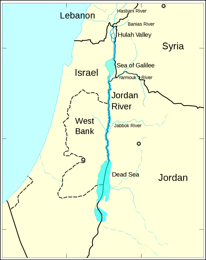

For now, Europe is being affected by drought, rivers are drying up, and agriculture is under pressure, nature is suffering. This is a war. A war for water, just like in Israel that confiscated the Golan Heights and West Bank for total control of the Jordan River and Sea of Galilee.
We must do everything in our power to try and put a stop to the fallout of climate change and indeed to counter it. But it is key, too, for us to understand how to manage the global drinking water.
Satellite data analyzed by researchers from Austria’s University of Graz at the start of the year found that drought was impacting Europe on a much larger scale than researchers had previously expected.

The study was published after EU researchers found that Europe experienced its hottest summer ever last year, with the intense drought thought to be the worst the region had seen in at least 500 years.
Summer after summer, Europe is suffering from a scarcity of water — and it just seems to get worse. This summer may be the worst of all. Spanish water resources were currently at less than 50% of their capacity.

The combination of a lack of rain and extreme temperatures is endangering our food security and the economic survival of millions of farmers.
Farming was one of the sectors likely to be hardest hit by diminishing water resources, making it more difficult to produce food. Our food security depends on the way we manage our water resources!
American Scientists bringing Animals back from Extinction

In a world where the delicate balance of nature is threatened by human activities, a group of American scientists has taken on an extraordinary mission.
Hidden away within the walls of San Diego Zoo’s frozen zoo, a remarkable collection is being safeguarded, containing a vast array of living cells from endangered and extinct species.
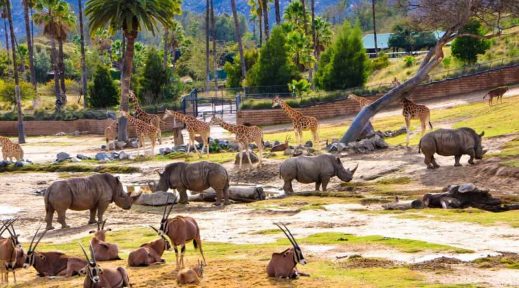
Established in 1975, this visionary project was conceived by Dr. Kurt Benirschke, who recognized the urgency of preserving these animals’ genetic materials for future generations.
Now, under the expertise of Marlys Houck and Barbara Durrant, the frozen zoo has become the largest and most diverse collection of its kind, housing over 10,000 individuals and nearly 1200 species and subspecies.
Through the power of freezing cells at bone-chilling temperatures, these scientists are holding these cells in suspended animation, their vitality waiting patiently to contribute to a groundbreaking solution – bringing species back from the brink of extinction.
Ancient Origins / ABC Flash Point News 2023.
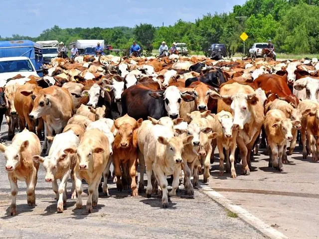
Texas floodwaters guided into ponds to protect Cattle business

They say when it rains, it pours, and that saying could not be truer than in the Texas Panhandle the last month. Over Memorial Day weekend, Hereford, Texas, one of the largest cattle feeding areas in the United States, received the brunt of a rain event, leading to historic rainfall totals and flood conditions.
Between 8 to 11 inches of rain accumulated in the Texas Panhandle town, much of it in a short period of time, causing the water to rise. The flash flood event left residents with little time to prepare and since the geographic area is extremely flat, the water had no natural exit.

Since the Panhandle only averages 15 to 25 inches annually, flooding is not a scenario the area experiences very often. The rising water caused evacuations of homes—destroying at least four residences—and causing devastating impacts to the agricultural industry.
Crops were underwater and livestock owners, dairies and feedlots are reporting many animal deaths.
The exact number is unknown at the moment, but with the large concentration of feedlots, the death loss is expected to be high. Fortunately, the water receded from the area around Hereford.

Feedlots are working to pump water out of pens, clean up the aftereffects of the floodwaters and move cattle to dry pens. Residents of the Panhandle are staying alert the next few weeks as rainy weather patterns are predicted, putting them in danger of more flooding.
We continue to be very thankful for the outpouring of support and assistance from friends, family, neighbors, communities, and [Texas Cattle Feeders Association] members during this unprecedented natural disaster resulting from a 500-year storm event in Deaf Smith and Castro counties.

Ben Weinheimer, president and CEO of Texas Cattle Feeders Association said that the recovery efforts have focused on caring for and feeding cattle that were unaffected by the storm; prioritizing the safety of our employees, workers and volunteers; repairing infrastructure such as roads and drainage ditches.
And pumping flood waters to other storage ponds that still have excess capacity; and managing the most unfortunate part of the disaster—properly removing and disposing of cattle that were lost.
We’ve been in close coordination with the Texas Commission on Environmental Quality and Texas Animal Health Commission throughout the response and recovery. Based on the latest weather forecast, we anticipate that current response and recovery activities will be completed in the next few days.
High Plains Journal / ABC Flash Point News 2023.
USA to combat biological threats against livestock

The $1.25 billion National Bio and Agro-Defense Facility in Manhattan, Kansas, took many years to come to fruition but those who gathered for a ribbon cutting on May 24 called it a proud achievement in the prevention of livestock diseases and protecting the nation’s food supply.
Four different buildings comprise the 574,000-square-foot, $1.25 billion biosafety level-4 research laboratory that is the successor to the aging Plum Island Animal Disease Center in Plum Island, New York.

This is designed to combat biological threats against livestock, predominantly cattle, swine and sheep, involving humans, according to NBAF Director Dr. Alfonso Clavijo, DVM.
U.S. Department of Agriculture Secretary Tom Vilsack said many people are to be thanked but he singled out retired U.S. Sen. Pat. Roberts, R-KS. He appreciated Roberts’ political expertise, saying it was not easy to convince colleagues over a long period of time to stay committed to seeing a project fulfilled.
It requires an extraordinary level of persistence, Vilsack said. He praised Roberts’ temperament and sense of humor plus his knowledge of the budgetary process. You were extremely lucky to have Pat Roberts where he was advocating so often, so forcefully and so passionately for this project.

Vilsack also praised former Department of Homeland Security Janet Napolitano who recognized NBAF’s importance. DHS accepted the responsibility for construction and once completed NBAF became the responsibility of USDA.
A land-grant university was the right location combined with long-term expertise in architectural, engineering, research and science.
The facility had to be secure. NBAF reinforces the message that collaboration and cooperation works when the mission is to protect citizens, he said. Kansans understand that message.

This is a state that understands, appreciates and respects agriculture. In his various roles, Roberts said he asked many questions about the dangers the U.S. and world’s agricultural sectors faced as a result of bio-terrorism. When 9-11 occurred, it spurred the process.
Plum Island, New York, could no longer provide the protection the nation’s food supply needs today. He had shared his concerns with the late K-State president Jon Wefald.
Wefald immediately told Roberts a new lab needed to be located at a land-grant university and the president put together an ambassador team to help sell Kansas State University.

Roberts remembered the many hours of research that went into informing various intelligence committees about the need to protect the nation’s food supply. One of his exercises was to demonstrate how devastating a widespread foot-and-mouth outbreak could be to the USA.
It helped to galvanize the livestock industry, commodity groups and researchers about the need for a unified message to protect the nation’s food supply. With help of then Kansas Gov. Kathleen Sebelius and state lawmakers they even withstood a last-ditch effort to have NBAF placed in Texas.
Kansas Gov. Laura Kelly also thanked K-State’s commitment to animal science research and the Manhattan community for its support throughout a lengthy construction process.
NBAF will put us on the front line of making the entire country and world safer, healthier and more resilient through research, training and diagnostics.
NBAF is at the center of the animal health corridor, she said, and that region includes 120 animal health companies that employ 13,000 specialists. The Manhattan location will foster research and collaboration between academia and public and private sectors.
The animal health corridor, which stretches from Manhattan to Columbia, Missouri, is important to protecting the nation’s food supply and is also part of a dream he champions, which is that children and grandchildren raised in this state have every opportunity to stay in Kansas and fulfill their dreams.
High Plains Journal / ABC Flash Point News 2023.
History of World Reserve Currencies since 1250

The world’s reserve currency fulfills a unique role in the global economy. It is the currency held in reserve by sovereigns, central banks, banks, and large businesses to facilitate the financing and transactions of global trade.
Importantly, all the currencies on the chart were backed by precious metals until we got to 1971 and the Eurodollar system.

It is important to view the world reserve currency as the currency which, during its time, facilitated the largest trade network. International trade is what a reserve currency is all about.
For over 1000 years, the Byzantine solidus, along with nearly identical offshoots like the gold dinar, dominated trade.
However, by 1250 the solidus had been massively debased leading to contracting economic integration between Central Asia, the Mediterranean, and Europe.

This is the void into which the Italian city-states stepped, by providing quality gold coins and facilitating trade in routes they maintained. Below we will examine these Italian coins and trace them from 1252 until 1535.
When the florin was minted in the 13th Century it was the first European gold coin struck in significant quantities for more than 500 years. In the 8th Century, the Carolingians introduced a silver standard to Northern Europe.
The florin spread quickly throughout Western Europe becoming widely recognized as the coin used in trade, debt, and accounting.

A vast network of Florentine bankers formed the first large international business enterprise and, when combined with a standard coin, were able to expand trade dramatically.
The florin was in many ways the first modern currency. We can see aspects of our current system emerging back then.
For example, modern accounting allowed the Medici bank to balance their books amongst branches which reduced the need to transport gold across the continent.

The florin was copied by others across Europe and is similar to the Eurodollar system today where dollars are created outside US jurisdiction.
For example, Genoa’s genovino, Hungary produced the forint and the Dutch minted the Guilder. Altogether about 150 locations minted a florin to the same weight and measure as the Florentines. The most important being Venice.
After a particularly troubling debasement of the Byzantine hyperpyron in the 13th Century, the Duchy of Venice started producing the Ducat which was modeled on the florin.

The ducat was almost identical in weight, at 3.545 grams, to the florin’s 3.5368 grams (the slight difference due to the measurement systems in the two city states).
The Venetian coin was used throughout the Levant, Anatolia, the Black Sea, and the Adriatic, circulating simultaneously with the florin in the West. The ducat and the florin were very similar and could be looked at as a single Italian reserve currency.
In the 15th Century, florins in several places in Western Europe suffered from debasement leading to a distinction between lower and higher quality florins. The debased coins eventually evolved into “guldens” while the higher quality florins were re-issued as ducats.

Therefore, by 1450, use of the term ducat incorporated much of what was previously known as the florin.
In the early 16th Century, the ducat’s role as reserve currency peaked and, by the middle of the century, suddenly lost its dominant role in trade. This 16th Century shift was similar in magnitude to the 14th Century shift from Byzantine coins to Italian.
The epicenter of currency now moved from Italy to Spain. Several important historical events precipitated this move: the uniting of Castile and Aragon (1479), the end of the Reconquista (1492), expansion of maritime exploration and trade (Columbus 1492), Hapsburg Spain (1516), and American silver mines (1535).

The year 1497 saw the ducat come to Spain when Ferdinand and Isabella enacted monetary reform with the Pragmatica de Medina del Campo.
This reform created a copy of the ducat, initially called the excelente, but which became known as the ducado (Castilian Ducat) in 1504.
Seven years later, in 1511, Maximilian I of the Holy Roman Empire began to mint a ducat (which was still produced in Austria until the 20th Century).

These two developments, the minting of a ducat in Spain and the Holy Roman Empire, fit nicely together five years later (1516) in the person of Charles V who was the Holy Roman Emperor and King of Spain (which included Sicily, Naples, Sardinia, and the Low Countries).
He controlled the largest trade network in the world at the time, and hence the world reserve currency. The ducat was used throughout his domains, but not for long, a new standard was just around the corner.
We will continue this series by first looking at the monetary changes occurring in the 14-15th Centuries and which culminated in a return to the silver standard 1535.
History of World Currency Reserves / Crickey Conservation Society 2023.
The Royal Tomb @ Machu Picchu, Peru

The Temple of the Condor in Machu Picchu is a breathtaking example of Inca stone-masonry. A natural rock formation began to take shape millions of years ago and the Inca skillfully shaped the rock into the outspread wings of a condor in flight.
On the floor of the temple is a rock carved in the shape of the condor’s head and neck feathers, completing the figure of a three-dimensional bird. Historians speculate that the head of the condor was used as a sacrificial altar. Under the temple is a small cave that contained a mummy.

A prison complex stands directly behind the temple, and is comprised of human-sized niches and an underground maze of dungeons.
According to historical chronicles that documented similar Inca prison sites, an accused citizen would be shackled into the niches for up to 3 days to await the deliberation of his fate. He could be put to death for such sins as laziness, lust, or theft.
Down a long set of stone stairs and to the left you’ll find the Royal Tomb. This cave-like area of Machu Picchu contains ceremonial niches and an Inca cross carved from one wall and is adjacent to the Temple of the Sun.

The cross resembles series of steps, and represents the three levels of existence in the world of the Inca. The first step, symbolized by the snake, represents the underworld or death.
The second step represents the present, human life, and is symbolized by the jaguar. The highest step represents the celestial/spiritual plane of the gods, and is symbolized by the condor.
Inside the Royal Tomb has been the site of numerous mummy excavations. Of more than 100 skeletal remains discovered here, 80% were women.
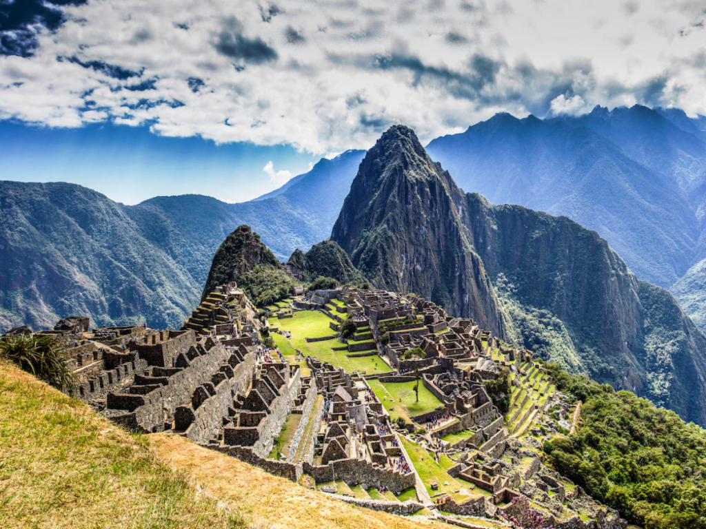
This fact, among others, leads many historians to surmise that the area was inhabited primarily by high priests and chosen women. The true purpose of Machu Picchu has never been conclusively determined.
To the left of the royal tomb lies a series of 16 ceremonial baths, joined by one linked aqueduct system. At the top of this system is the watershed hut. Continuing along the left side of the complex, you will cross the rock quarry and come across the Sacred Plaza.
Machu Picchu / Crickey Conservation Society 2023.
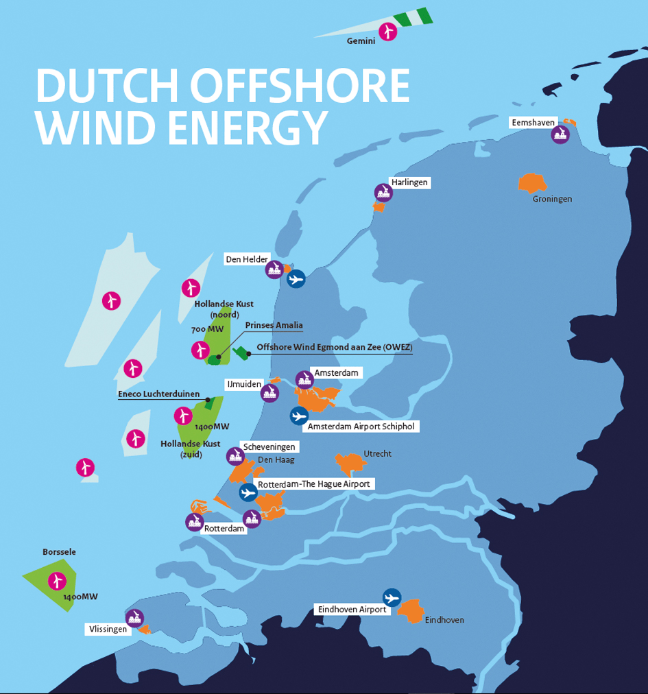
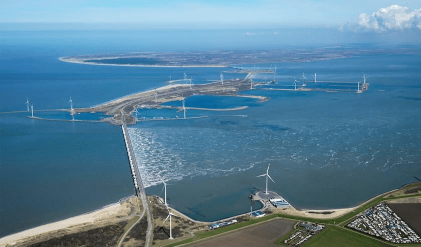
Windmolenpark op de Noordzee

Met een ramp in wording drukt het kabinet het plan door, zonder de gevolgen te onderzoeken? Het gaat dus gebeuren: een gigantisch windmolenpark op onze Noordzee.
Ondanks alle bezwaren, die uit allerlei hoeken komen en op heel wat te verwachten problemen wijzen, zet men door en houdt men zich, zoals we dat inmiddels kennen, doof voor alle kritische stemmen. De windmolens moeten en zullen er komen.

Het onderzoek naar de gevolgen ervan is nog lang niet klaar, is nog in volle gang, maar de beslissing is al genomen, schrijft Ines van Bokhoven. Kritische stemmen zijn er genoeg, en er lijken er alleen maar meer bij te komen.
Want deze vorm van energieopwekking die ons is verkocht als ‘schoon en milieuvriendelijk’, is geen van beiden. Nee, windenergie is niet schoon, zoals ik al beargumenteerde in een stuk, en zoals steeds meer mensen proberen onder de aandacht te brengen.
Alleen al de giftige microplastics die van die dingen afwaaien brengen zowel onze gezondheid als het milieu danig in gevaar. Dat Flevoland onlangs aan de bel trok wegens hoge concentraties bisfenol A in het grondwater wekt geen verbazing: die provincie staat barstensvol met windmolens.

Windmolens verpesten het milieu, en dat is maar een van de vele bezwaren tegen deze ondingen.
Al meer dan tien jaar geleden werd het ‘windmolensyndroom’ vastgesteld: mensen die in de directe nabijheid van dergelijke molens wonen ervaren allerlei gezondheidsklachten en overlast – klachten die uiteraard worden genegeerd.
De aanslag op ons landschap is er ook eentje: juist de plekken die mooi leeg zijn, waar een mens nog in de verte kan kijken, worden volgeplempt met afzichtelijke palen die elk plezier in het om je heen kijken bederven. Ons landschap wordt volledig verpest.

Windturbines veroorzaken onder meer laagfrequent geluid, slagschaduw en – knipperende – lichten. Dat kan tot gezondheidsproblemen leiden, die echter nog te weinig serieus worden genomen. Terwijl volgens het voorzorgprincipe de overheid kan ingrijpen, ook als klachten nog niet onomstotelijk bewezen zijn.
Ten aanzien van milieu en gezondheid geldt in Nederland het voorzorgsbeginsel. Dit houdt in dat de overheid beschermende maatregelen kan nemen tegen mogelijk schadelijke milieueffecten van een situatie, ook als die effecten nog niet onomstotelijk zijn bewezen.
Het beginsel gaat dus over de vraag hoe te handelen bij wetenschappelijke onzekerheid.

Provincies en gemeenten werd bijvoorbeeld geadviseerd om bij ruimtelijke ontwikkelingen zoveel mogelijk te vermijden dat kinderen langdurig in de magneetveldzone van een hoogspanningsleiding verbleven vanwege de aanwijzingen dat deze de kans op leukemie bij kinderen verhoogden – inmiddels is er voor deze relatie overigens voldoende bewijs.
Het is tijd dat het voorzorgsbeginsel ook wordt toegepast bij de bouw van windturbines in de bewoonde omgeving, omdat ook hier ruim voldoende aanwijzingen zijn voor gezondheidsschade bij omwonenden.
Een substantieel deel van omwonenden van windturbines rapporteert wereldwijd identieke klachten.
Chronische slaapproblemen, hoofdpijn, tinnitus, een drukgevoel op de oren, vertigo, visusklachten, luchtwegproblemen, tachycardie, prikkelbaarheid, concentratie- en geheugenproblemen, en angstgevoelens samengaand met de sensatie van inwendige pulsaties of trillingen zowel slapend als in wakkere toestand.
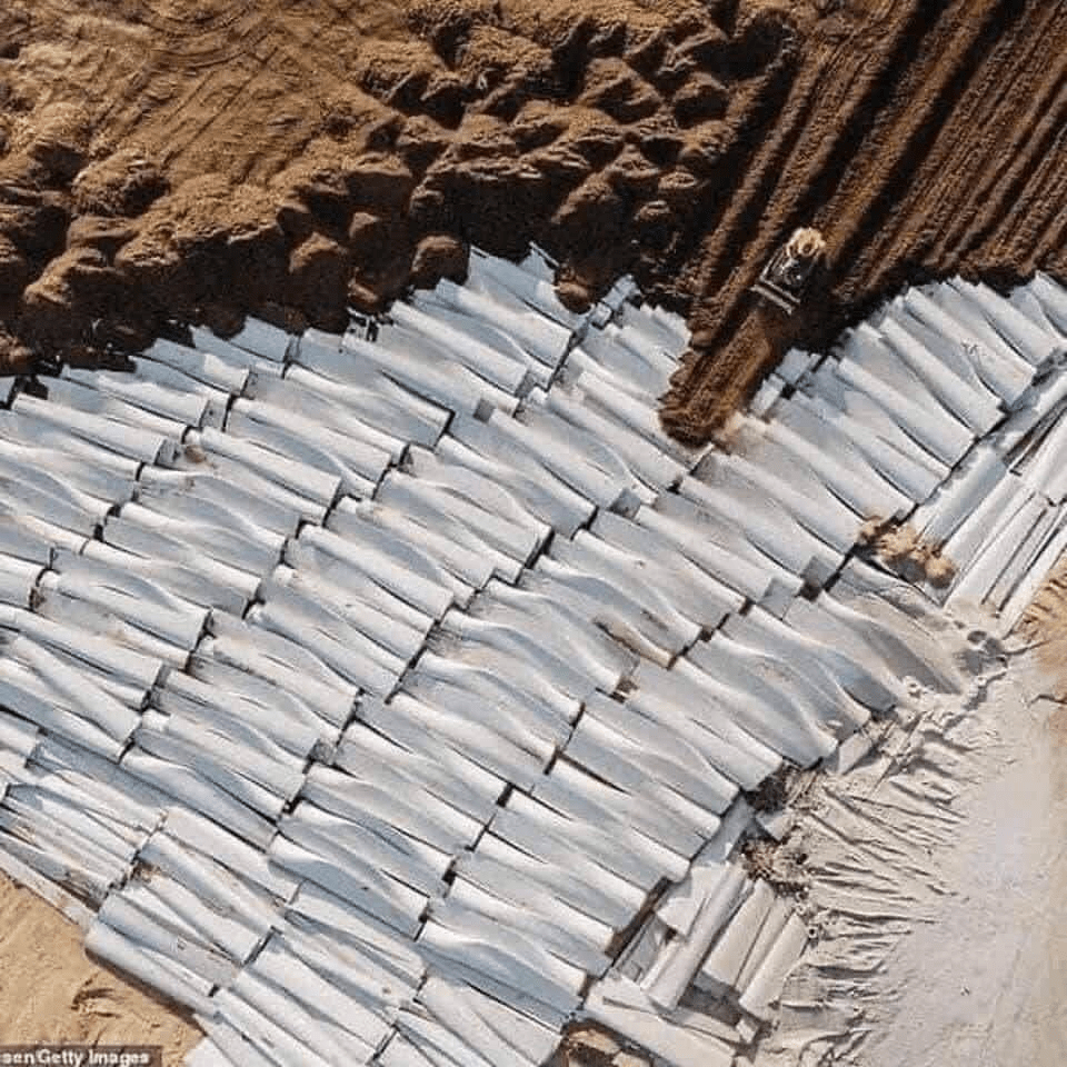
De natuur wordt al aangetast als de beslissing tot plaatsen van zo’n molen valt: het gebied moet worden voorbereid en dat houdt vaak grootschalige bomenkap in.
Hele hectares met eigen ecologische systemen worden kaal gemaakt en doods achtergelaten, om vervolgens voorzien te worden van een infrastructuur, zoals de wegen die moeten worden aangelegd om de molens met grote, smerige vrachtwagens op hun plek te krijgen.

Grote betonnen platforms waar niets meer op wil of kan groeien, die de plaats hebben ingenomen van wat ooit een florerend stukje natuur was. Dan is er de aanslag op vogels en vleermuizen, soms zelfs beschermde soorten, die vaak danig wordt onderschat.
Vogels en andere vliegende beesten die in sommige perioden (vooral tijdens hun trek) met bosjes gehalveerd of onthoofd neerstorten. En hoeveel dat er precies zijn is moeilijk te meten, dus zeggen de experts: ga er maar vanuit dat het er veel meer zijn dan we opmerken.
Want een dood beest op de grond is voedsel voor een heleboel andere dieren, en is vaak allang weg voordat wij hebben geconstateerd dat-ie er überhaupt ooit lag.

De aanslag op onze natuur is hartverscheurend, niet om aan te zien, verontrustend, en het ergste is nog wel dat men maar blijft gillen dat men het doet om ‘de natuur’ te redden.
We kunnen de schade met eigen ogen zien, maar onze beleidsmakers hebben er geen oog voor. Met oogkleppen groter dan de gemiddelde Nederlandse provincie ramt men de plannen gewoon door, want er is geld en macht mee gemoeid en dan weten we het wel weer.
En dan de aanleg van zo’n park-op-zee zelf: dat staat er ook niet van vandaag op morgen. Dat gaat jaren kosten, met alle bijbehorende vervuiling en herrie. En staat het er eenmaal, dan weten we niet wat het effect ervan gaat zijn op de ecologie in dat zeegebied.

Maar het wordt erger. Studies tonen al een tijdje aan dat windmolens een negatief effect hebben op het lokale klimaat van het gebied waar ze in staan – studies die door geen enkele klimaatlobby worden meegenomen in de besluitvorming, lijkt wel.
En die studies liegen er niet om: windmolens veroorzaken droogte. En stevig ook.
Windmolens hebben namelijk een merkwaardig effect op de wind: ze keren luchtlagen om met hun draaibewegingen. Warme, hogere luchtlagen komen daardoor dichter bij de grond dan dat ze horen te zijn, vooral ’s nachts, en de vochtige lagen komen te hoog terecht.

Dat is waarschijnlijk de reden dat men begint op te merken dat in gebieden waar veel windmolens staan ook steeds meer droogte optreedt: soms tot bijna twee meter diep droogt de toplaag uit.
De vraag is dus ook wat deze ‘windomkeringen’ op lange termijn voor het klimaat op onze planeet gaan betekenen, gezien de mega-uitbreidingen van windparken die men van plan is uit te voeren.
Want met zo’n lading van deze palen op de planeet is het niet moeilijk te beseffen dat dit al vlot geen lokaal, maar wereldwijd probleem zal worden.
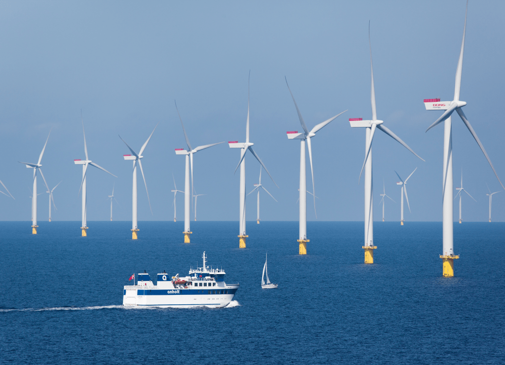
Vooral bij windmolens op zee is goed te zien wat er gebeurt met de wind die langs waait: volslagen onnatuurlijke wervelwinden komen achter de molens los en zorgen ervoor dat vochtige lucht, die onderop dient te zitten, in bovenlagen terecht komt.
Het windmolenpark dat men nu plant op de Noordzee zou zomaar eens voor grote problemen met onze bodem kunnen gaan zorgen – maar omdat er geen goed onderzoek naar wordt gedaan, weten we dat dus niet.
Het is afwachten en dan straks weer een verse crisis om de nieuwe problemen op te lossen – problemen die voorkomen hadden kunnen worden door naar critici te luisteren.

Maar naar critici wordt niet geluisterd, hoewel het protest tegen al deze gevaarlijke, vervuilende, ziekmakende verschijnselen die windmolens veroorzaken gelukkig steeds meer toeneemt en steeds luider wordt.
Onze politieke elite wil windmolens en dus komen er windmolens – al zorgt hun achterban er dan weer wel voor dat zij zelf zo weinig mogelijk overlast van die dingen hebben.
Windmolens zijn mooi, maar niet als ze ten koste gaan van het woongenot en de huizenprijzen van precies dezelfde mensen die willen dat die dingen er komen. Knal die maar ergens op het platteland neer, bij de mensen waar we toch al jaren niet meer naar luisteren.
En dan hebben we het nog niet gehad over het probleem van het giftige afval, want een windmolen gaat maar een jaartje of 20-25 mee, en daarna moeten we er weer ergens mee heen, hè?
Dus wat te doen met de palen en wieken van steeds groter wordende windmolens waarvan we er steeds meer aan het neerzetten zijn?
En zo denderen we voort, terwijl we niet eens weten wat we aan het doen zijn.
We hebben geen idee wat de effecten zullen zijn van duizenden windparken over de hele planeet, en wat we wel weten negeren we krampachtig, want de steeds langer wordende lijst aan negatieve onderzoeksuitslagen dient het mooie plaatje dat men probeert te schetsen absoluut niet.
De leugens over ‘hernieuwbare, duurzame en schone’ energie vliegen ons om de oren, en het wordt steeds duidelijker dat het leugens zijn. Schone energie bestaat niet, elke munt heeft een keerzijde en lullige feiten negeren omdat je ze niet wilt weten is zo ongeveer het domste dat je kunt doen.
Ik hou mijn hart vast voor de ramp die we de komende jaren gaan meemaken dankzij de stupiditeiten van hoogopgeleide, domme mensen.
Opinie Z / Crickey Conservation Society 2023.
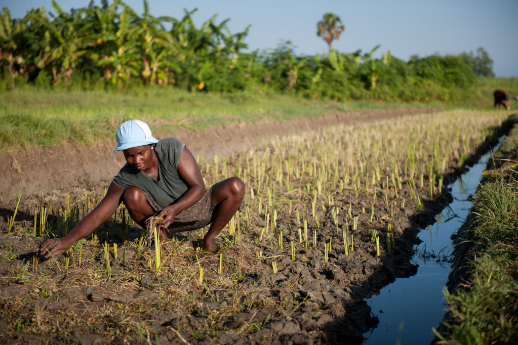
Urban development causing Worldwide landslides

Creeping from just a finger’s width up to a few feet per year, slow-moving landslides occur naturally throughout the world. They typically are detected inching down-slope in rocky areas with high seasonal precipitation and clay-rich soil, and they can take months to years – even centuries – to develop.
Yet they can also bring sudden violence. Thousands of landslides are flowing, slipping, toppling, and sliding down hills from coastal California to China’s Three Gorges Reservoir. How these stealthy geologic phenomena respond to urban development has not been well understood.

Now a team of international researchers, including one from NASA’s Jet Propulsion Laboratory, has combined satellite and archival imagery to show how one African city’s changing water usage influences land movements near and just below the surface.
The new NASA study zeroed in on Bukavu, a hillslope city in the Democratic Republic of the Congo. The researchers noted that Bukavu – with a population estimated to double to more than a million inhabitants by 2030 – is emblematic of many cities in the developing world that have seen rapid and unplanned growth on tectonic active landscapes.
The city, originally established along the flat shoreline of a lake, has been expanding up steep slopes. Along the way, parts of Bukavu have experienced slow, ongoing destruction of infrastructure due to ground surface motion.
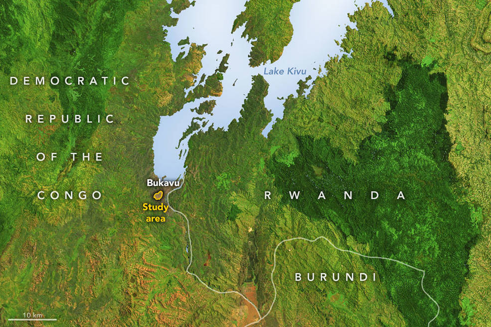
One of these active zones is the Funu neighborhood, where 80,000 people live, often in poor-quality housing, on top of a slow-moving landslide that shifts continuously up to 9 feet (3 meters) per year.
To measure the land motion, the research team analyzed radar data collected by the Sentinel-1 satellites of the ESA (European Space Agency) and the COSMO-SkyMed satellite from the Italian Space Agency (ASI).
The measurements were processed into maps showing land movement and then related to a number of landslide-triggering factors such as rainfall, earthquakes, and urban development.

To better visualize how Bukavu has transformed in recent decades, the team also drew on more than 70 years of aerial photographs (from 1947 to 2018) archived in the Royal Museum for Central Africa in Belgium.
The images document a mushrooming cityscape. One reason for the growth is an influx of people fleeing violence in the broader region, where Bukavu is seen as a safe haven.
Focusing on week-to-week landslide motion over the past 4 1/2 years, the researchers found that rainfall, tectonic activity, and urban development all played roles in landslide behavior across seasons and years. But the most important factor was water runoff.

For one of the first times, we were able to document a clear connection between the growth of a city and the acceleration of a slow-moving landslide, said Alexander Handwerger, a landslide scientist at JPL and a co-author of the study.
We think this is driven by changes in slope hydrology – the way that water flows into the ground there – and not the additional weight of the houses on top.
Water weakens rock by infiltrating its pores. In urban settings, infrastructure such as roads, storm drains, and ruptured pipes can drastically alter water flow, soaking and destabilizing parts of a slope.
The cycle is self-reinforcing: Rerouting water flow weakens the slope, which in turn damages plumbing infrastructure, which releases more water into the rock.
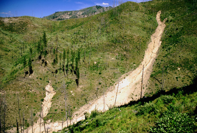
Compared to high-velocity landslides (such as mudslides or lahars), which cause thousands of casualties and billions of dollars in damage each year, slow-moving landslides pose less of a threat to human lives. But inch by inch, year by year, they can cause mounting destruction.
And on occasion they have been known to accelerate catastrophically. A recent example is the 2017 Mud Creek landslide near Big Sur, California, which dislodged about 6 million cubic yards (5 million cubic meters) of rock and debris across state Highway 1.

More attention should be paid to slow-moving landslides, the researchers said, because the current rate and scale of urban growth globally are unprecedented in human history.
When populations migrate to potentially unsafe landscapes such as hill-slopes, more people will be exposed to these natural hazards. Understanding how urban sprawl influences Earth’s surface will be vital to plan for and mitigate risk to communities.
Attention is typically focused on landslides located in high-income, high-latitude countries, while landslide impacts disproportionately affect tropical areas where extremely rapid changes are taking place, such as population growth and environmental degradation, said Antoine Dille, the study’s lead author and a scientist at the Royal Belgian Institute of Natural Sciences.

A space mission set to launch in 2024 could help provide even better information on these processes: The NASA-Indian Space Research Organization Synthetic Aperture Radar (NISAR) mission will observe surface changes around the world with accuracies down to a fraction of an inch.
Such data will help scientists and policymakers protect lives and property by better monitoring subtle motions connected to landslides, earthquakes, volcanic eruptions, and other natural hazards.
NASA / Crickey Conservation Society 2023.
The 10 lost tribes of Israel

The ten lost tribes refers to the legend concerning the fate of the ten tribes constituting the northern Kingdom of Israel.
The Kingdom of Israel – consisting of the ten tribes (the twelve tribes excluding Judah and Benjamin who constituted the southern Kingdom of Judah) – fell in 722 B.C.E. and its inhabitants were exiled by the Assyrians. In general, it can be said that these tribes disappeared from the stage of history.
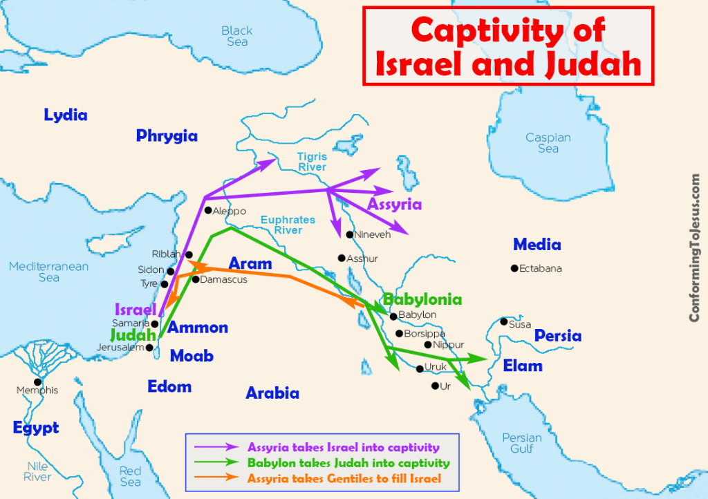
However, the passage in I Chronicles 5:26 to the effect that the ten tribes were there “unto this day” and the prophecies of Isaiah (11:11), Jeremiah (31:8), and above all of Ezekiel (37: 19–24) kept alive the belief that they had maintained a separate existence and that the time would come when they would be rejoined with their brethren, the descendants of the Exile of Judah to Babylon.
Their place in history, however, is substituted by legend, and the legend of the Ten Lost Tribes is one of the most fascinating and persistent in Judaism and beyond it.
The belief in the continued existence of the ten tribes was regarded as an incontrovertible fact during the whole period of the Second Temple and of the Talmud.

Tobit, the hero of the apocryphal book of his name, was depicted as a member of the tribe of Naphtali; the Testament of the 12 Patriarchs takes their existence as a fact; and in his fifth vision, IV Ezra (13:34–45) saw a peaceable multitude, these are the 10 tribes which were carried away prisoners out of their own land.
Josephus (Ant., 11:133) states as a fact the ten tribes are beyond the Euphrates till now, and are an immense multitude and not to be estimated in numbers.
Paul (Acts 26:6) protests to Agrippa that he is accused for the hope of the promise made unto our fathers, unto which promise our twelve tribes, instantly serving God, hope to come, while James addresses his epistle to the twelve tribes which are scattered about (1:1).

The only opposing voice to this otherwise universal view is found in the Mishnah. R. Eliezer expresses his view that they will eventually return and after darkness is fallen upon the ten tribes light shall thereafter dwell upon them, but R. Akiva expresses his emphatic view that the 10 tribes shall not return again (Sanh. 10:3).
In consonance with this view, though it is agreed that Leviticus 26:38 applies to the ten tribes, where R. Meir maintains that it merely refers to their exile, Akiva states that it refers to their complete disappearance (Sifra, Be-Ḥukkotai, 8:1).
Their inability to rejoin their brethren was attributed to the fact that whereas the tribes of Judah and Benjamin (the Kingdom of Judah) were scattered throughout the world, the 10 tribes were exiled beyond the mysterious river *Sambatyon (Gen. R. 73:6), with its rolling waters or sand and rocks, which during the six days of the week prevented them from crossing it, and though it rested on the Sabbath, the laws of the Sabbath rendered the crossing equally impossible.

According to the Jerusalem Talmud, however (Sanh. 10:6, 29c), the exiles were divided into three. Only one-third went beyond the Sambatyon, a second to “Daphne of Antioch,” and over the third there descended a cloud which covered them; but all three would eventually return.
Throughout the Middle Ages and until comparatively recent times there were claims of the existence of the ten lost tribes as well as attempts by travelers and explorers, both Jewish and non-Jewish, and by many naive scholars, both to discover the ten lost tribes or to identify different peoples with them.
In the ninth century *Eldad ha-Dani claimed not only to be a member of the tribe of Dan, but that he had communicated with four of the tribes.

David *Reuveni claimed to be the brother of Joseph the king of the tribes of Reuben, Gad, and the half-tribe of Manasseh who were settled in Khaybar in Arabia, which was identified with the Habor of II Kings. Benjamin of Tudela has a long description of the ten tribes.
According to him the Jews of Persia stated that in the town of *Nishapur dwelt the four tribes of Dan, Asher, Zebulun, and Naphtali, who were then governed by their own prince Joseph Amarkala the Levite [ed. by N.M. Adler (1907), 83], while the Jews of Khaybar are of the tribes of Reuben and Gad and the half-tribe of Manasseh” (ibid., 72), as was also stated by Reuveni.
Persistent was the legend that they warred with Prester John in Ethiopia, a story repeated by Obadiah of *Bertinoro in his first two letters from Jerusalem in 1488 and 1489. The kabbalist Abraham Levi the elder, in 1528, identified them with the Falashas (see *Beta Israel ).

Jacob *Saphir (1822–1888) cherished the hope that he would discover the lost tribes.
He tells the story in great detail of Baruch b. Samuel, a Jew of Safed who, sent to seek them, had visited Yemen and after traveling through an uninhabited desert established contact with a Jew who claimed to belong to the “sons of Moses.
However, Baruch was murdered before he could visit them (Even Sappir, 1 (1866), 41), and in the following chapter Saphir transcribes word for word the evidence given by a certain Baruch Gad to the rabbis of Jerusalem in 1647 that he had met the sons of Moses in Persia, who gave him a letter to Jerusalem.

He concludes wistfully, Were I able to give full credence to this letter… I would subject it to a meticulous analysis and woad learn from it matters of supreme importance, but the recollection of the fraud of Eldad ha-Dani brings suspicion upon Baruch the Gadite, for one supports the other.
I have done my duty by putting the facts down and you may judge for yourselves and I will hear also what contemporary scholars say about it. Various theories, one more farfetched than the other, have been adduced, on the flimsiest of evidence, to identify different peoples with the ten lost tribes.
There is hardly a people, from the Japanese to the British, and from the Red Indians to the Afghans, who have not been suggested, and hardly a place, among them Africa, India, China, Persia, Kurdistan, Caucasia, the U.S., and Great Britain.

Special interest is attached to the fantastic traveler’s tale told by Aaron (Antonio) Levi de *Montezinos who, on his return to Amsterdam from South America in 1644, told a remarkable story of having found Indians beyond the mountain passes of the Cordilleras who greeted him by reciting the Shema.
Among those to whom Montezinos gave his affidavit was *Manasseh Ben Israel , then rabbi of Amsterdam, who fully accepted the story, and to it devoted his Hope of Israel (1650, 16522) which he dedicated to the English Parliament.
- That the West Indies were anciently inhabited by a part of the ten Tribes, which passed thither out of Tartary, by the Streight of Anian.
- That the Tribes are not in any one place, but in many; because the Prophets have fore-told their return shall be into their Country, out of divers places; Isaiah especially saith it shall be out of eight.
- That they did not return to the Second Temple.
- That at this day they keep the Jewish Religion.
- That the prophecies concerning their return to their Country, are of necessity to be fulfilled.
- That from all coasts of the World they shall meet in those two places, sc. Assyria and Egypt; God preparing an easier, pleasant way, and abounding with all things, as Isaiah saith, ch. 49, and from thence they shall fly to Jerusalem, as birds to their nests.
- That their Kingdom shall be no more divided; but the twelve Tribes shall be joined together under one Prince, that is under Messiah, the Son of David; and that they shall never be driven out of their Land.
Jewish Virtual Library / Crickey Conservation Society 2023.
How British women helped to abolish slavery in 1804

Believe it or not, but by the 1700’s, deciding whether or not to take sugar with your tea had become a political statement. While sugar-free diets are now all the rage, the motivations behind this health trend are a far cry from those of the anti-saccharine during the abolitionist sugar boycotts of Britain and North America.
By the 18th century drinking tea sweetened with sugar was a staple of millions of British households. This in turn helped fuel the despicable trade in slaves, necessary to keep the price of sugar low and keep up with the ever-increasing demand.
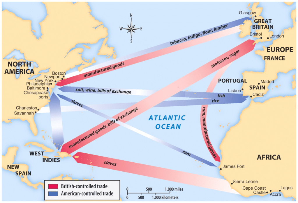
According to Royal Museums Greenwich , between 1662 and 1807 Britain human trafficked over three million Africans to the Americas as slaves.
Many of these ended up working on sugar plantations in the Caribbean, famed for inhumane conditions and high death rates. Estimates claim that by the end of the 18th century, over 400,000 slaves had perished in the process.
The Haitian Declaration of Independence was proclaimed on 1 January 1804 in the port city of Gonaïves by Jean-Jacques Dessalines, marking the end of 13-year long Haitian Revolution. The declaration marked Haiti’s becoming the first independent Black nation in the Western Hemisphere.

After the independence of Haiti, sugar needed to be boycotted, so the former slave labor population could not be successful on its own. They were also forced to sign and pay for the losses of the slave labor corporations in Haiti.
Christian Quakers in Britain and America led the movement against slavery. Rejecting class divisions, they viewed slavery as contradictory to their principles.
Sugar came to represent the corrupting force of greed and the Quakers began to understand the power of ethical consumer choices in shaping the political landscape.

By the early 1800’s, eating sugar was about as acceptable as displaying tusks of ivory in one’s living room is today, explained NPR. In the 1820’s, sugar bowls adorned with anti-slavery slogans had become a popular trend, with consumers opting for sugar sourced in India instead.
Due to pressure from the abolitionist movement, by 1807 King George III had signed the Act for the Abolition of the Slave Trade, effectively banning the slave trade in the British Empire . Nevertheless, many slavers defied the new legislation and slavery continued to exist in the Caribbean.
This provoked another sugar boycott in the 1820’s, exerting pressure on the government. Nevertheless, it was only in 1833, with the Slave Emancipation Act, that British slavery gradually came to an end.
While most people associate the movement with Thomas Clarkson and William Wilberforce, women and children played a crucial role promoting the boycott and in deciding their household consumption.
A study from the University of Exeter highlighted the production of antislavery children’s literature and the role Georgian children played by refusing to eat products made with sugar.
Ancient Origins / ABC Flash Point News 2023.
