The Pantanal is a land of superlatives. The largest tropical wetland in the world. A biodiversity hot spot. Home to South America’s “Big Five”: Jaguar, Giant Anteater, Giant River Otter, Maned Wolf & Brazilian Tapir.
Not to mention the Pantaneira culture, shaped by an unforgiving landscape. What the floodplain landscape lacks in elevation it holds in wonder.
An annual flood and dry cycle is the life pulse of this extraordinary area of 17 million in Brazil, Bolivia and Paraguay. The area, 10 times the size of the Everglades, is an enormous depression draining slowly to the Paraguay River.
Though much of the Pantanal is remote and difficult to access, it is threatened by deforestation (more than 40% of forest and savanna habitats have been converted to cattle ranches); disruption of water flows due to large infrastructure projects within the wetlands and general development upstream; and pollution, primarily from pesticide application upstream.
Only 4.6% of the Brazilian Pantanal is formally protected, and management capacity in many of those areas is stretched thin.
Enter the Social Service of Commerce (Sesc), a private social corporation providing educational, recreation and health services to Brazil’s workers.
For its first 50 years, Sesc focused on urban areas but, inspired by the first Rio Earth Summit in 1992, they embarked on a social-environment program.
Sesc purchased a number of contiguous cattle ranches, or fazendas, restoring nature across 108,000 ha, representing 2% of the Pantanal in the state of Mato Grosso.
The Private Natural Heritage Reserve (RPPN from its acronym in Portuguese) has thus far documented more than 350 bird species, 189 plant species, 157 fish, 23 amphibians, and 83 mammals, including all of South America’s “big five”.
Conservation Success and Ongoing Research
In the 20 years since the fazendas were purchased and allowed to go fallow, natural regeneration has restored habitats across the reserve to a near-natural state. Research is underway to document the changes.
Sesc Pantanal has hosted 170 researchers on 65 projects. Current research includes migratory shorebird routes; the role of fish in certain plant distributions; climate monitoring with the National Institute of Space Research (INPE); and ecology of the jaguar, Panthera onca, yellow anaconda, Eunectes notaeus, and caiman, Caiman yacare.
One success story is that of the Hyacinth macaw, Anodorhynchus hyacinthinus, the largest of the parrot species.
Recently upgraded on IUCN’s Red List to “vulnerable,” there were only 18 individuals on the property when RPPN Sesc Pantanal was created 20 years ago. Today the population numbers 450 and trends indicate the population will continue to increase.
Sesc Pantanal was recognized as a Wetland of International Importance under the Ramsar Convention in 2002.
The reserve manager serves as a national focal point for the 25 Ramsar sites in Brazil. Two others are in the Pantanal, including another RPPN, Fazenda Rio Negro in Mato Grosso do Sul.
Governance, Capacity, Infrastructure
RPPN Sesc Pantanal employs 11 rangers and 10 assistants, plus a reserve manager, Dr. Cristina Cuiabália Neves, and 5 staff at an education center and butterfly house. The hotel provides additional interpretive services to guests, as well as equipment.
Sesc maintains seven field stations distributed across the reserve, former ranch buildings retrofitted for monitoring and research needs. Each has an airstrip to facilitate access, a fire tower, and fire suppression equipment.
(Threats to the reserve include fire in the dry season, predatory fishing, disruption of water sources upstream, and some narco-trafficking. Poaching is limited because most of the reserve is not easily accessible, and rangers are not armed.)
This staff capacity stands in contrast to Pantanal National Park, which is about the same size but has only three staff and two boats. The comparison is not entirely fair, however, as the national park is deeper in to the Pantanal and even less accessible than the RPPN.
Though private, management of the RPPN is regulated by the Chico Mendes Institute for Biodiversity Conservation (ICMBio).
The reserve maintains an advisory council of 10 institutions (mostly government but including WWF) plus three individual research scientists.
The reserve is one of five units of Sesc Pantanal in this region of Mato Grosso state—others are the Hotel Sesc Porto Cercado; two smaller parks; and a more traditional service center in Poconé—all overseen by an administrative office in the state capital of Cuiabá.
This structure is significant to the sustainability of reserve management.
Supporting Local Livelihoods
The owner of the RPPN, Sesc, is an interesting institution with a unique financing mechanism. The Serviço Social do Comércio (Social Service of Commerce) was created by retail businessmen in the 1940’s.
It is the largest arts organization in Brazil, and also provides recreational, health and educational services. Though a private, nonprofit entity it is established by national decree and is funded by a 1.5 percent payroll tax.
This funding stream complements profit from the hotel to cover management costs of this large reserve.
Sesc operates across the country, but primarily in urban areas. Sesc Pantanal is its largest enterprise in a rural area. As touted in one of their publications, with the RPPN in the Pantanal, “Sesc has gone country.
The RPPN is also their national socio-environmental hub.
Sesc Pantanal supports local livelihoods. All of the park rangers are local, most from a village just north of the reserve. They work twelve days on and four off. In the rainy season their commute is four hours or more by horseback.
Sesc also operates a 400-guest hotel, spa and conference center adjacent to the reserve; it’s staff commute from the nearest town, Poconé.
The hotel includes an education center and a butterfly house. Local people in Poconé are given butterfly eggs to rear and then paid for pupae to populate the lepidopterarium
International Union for Conservation if Nature / ABC Flash Point News 2026.
Sun as the Source of Life The Sun provides the energy that makes life on Earth possible. Its light drives photosynthesis allowing plants to produce food and oxygen which supports almost all living organisms.
Day and Night Cycle The rotation of Earth under the Sun creates day and night. This cycle controls sleeping, feeding and activity patterns in humans, animals and plants.
Biological Clocks (Circadian Rhythms) Sunlight regulates circadian rhythms in living beings. These internal clocks control sleep, hormone release, body temperature and alertness.
Seasons and Growth Cycles The Sun’s position changes throughout the year, creating seasons. Seasonal sunlight affects plant flowering, crop cycles, animal migration and breeding periods.
Climate and Weather Influence Solar energy drives wind, rain and ocean currents. These climate patterns shape ecosystems and determine where different species can survive.
Moon and Ocean Tides The Moon’s gravity causes ocean tides. Tides influence coastal ecosystems, nutrient movement and marine life behavior.
Marine Life Cycles Many sea creatures time their feeding, migration and reproduction with lunar cycles and tidal changes.
Nocturnal and Lunar Behavior Moonlight affects nighttime animals. Some species hunt, mate or move based on the Moon’s brightness and phases.
Monthly Rhythms The Moon’s phases create monthly cycles that influence biological and environmental patterns especially in aquatic and nocturnal species.
Balance Between Sun and Moon Together, the Sun and Moon create stable, predictable rhythms. Life on Earth has evolved to depend on these cycles for survival and balance.
The desperate elite are engineering the next phase of their control agenda, leveraging fear and panic through a new disease.
According to a whistleblower from the Gates Foundation, Bill Gates has ramped up preparations for Disease X, a looming health crisis designed to justify forced vaccinations and forever lock-downs in 15 minute cities across the Western world.
If you’ve been connecting the dots, the pattern is disturbingly familiar: prominent tabletop exercises involving Bill Gates, the WEF and the WHO, mainstream media amplifying fear with synchronized narratives, governments quietly rewriting laws to enforce vaccinations, and Klaus Schwab dropping cryptic hints about the end of America and death of the nation state.
It’s a chilling rerun of the COVID-19 strategy, playing out in real time.
The eerie resemblance begs the question: is Disease X the catastrophic event Bill Gates ominously hinted at, the one that would get everyone’s attention this time?
And is the vaccine they’ve miraculously prepared in advance the same one Gates once ominously referred to as the final solution for humanity?
Three years ago billionaire eugenicist Bill Gates appeared on mainstream TV and used Third Reich terminology to describe the elite’s final solution for humanity.
Gates wasn’t joking. The vaccines they pushed onto the global population have already inflicted immense harm, drastically reducing numbers and leaving survivors with long-term damage.
But the elites aren’t stopping there—their plans are far from over. According to the authoritarian health dictator at the WHO, Disease X is looming on the horizon and will definitely strike soon.
Of course, WEF-infiltrated governments are fully on board with the roll out. In moves that mirror Fauci’s deadly gain-of-function experiments, Britain’s highly secure Porton Down facility, which specializes in chemical and biological warfare, is said to be experimenting with Disease X.
Here is the BBC with a classic example of fake news fearmongering. How is it even possible there is already a vaccine for Disease X?
For those on Team Reality, the fact they are working on a vaccine for Disease X in a chemical and biological weapons lab should tell you all you need to know.
Whenever the global elite, world leaders, and mainstream media begin singing from the same hymn sheet, we must tread very carefully, analyze everything they are saying, and call them out on their fearmongering and lies.
Remember, the dissemination of fear is a control tactic designed to terrify the sheep into submission.
As Dr. Johns Campbell explains, the WEF have now joined the chorus of fake news propaganda, which means the false flag viral outbreak designed to cripple the incoming Trump presidency and destroy the sovereignty of nation states is almost complete.
If Disease X is making absolutely no sense to you at all – then congratulations, you are in good company.
Anyone who survived the mass formation psychosis of the Covid-19 pandemic and came out the other side with their critical thinking skills intact is thinking the exact same thing you are.
With knowledge comes responsibility. As those who can see through the elite’s agenda, it’s our duty to ensure they don’t succeed in pulling the same stunt again.
Given their ambitions to seize total control over humanity, the stakes could not be any higher. Make no mistake, the plans to unleash Disease X on humanity have been in the works for years.
How do we know? Because as usual, the elite told us about their intentions in advance.
It’s called Revelation of the Method, a dark occult practice in which the elite subliminally broadcast their plans to humanity and then take the lack of resistance to be implied consent.
The Disease X has been planned down to the last detail. Is this the pandemic Gates smugly announced would get our attention this time?
We all know that COVID had a rehearsal within the Event 201tabletop exercise. The exercise was conducted by the Bill and Melinda Gates Foundation in partnership with the World Economic Forum back in 2019.
Unsurprisingly, Disease X has also been rehearsed, this time at the Johns Hopkins Center for Health Security which hosted the Clade X pandemic tabletop exercise on May 15, 2018, in Washington, DC.
At the Clade X event, the NSA assembled a team of top advisors to discuss the mysterious illness which they say will emerge first in Germany and Venezuela, leading to a massive loss of life in just 36 hours and economic collapse.
Of course, the Bill & Melinda Gates Foundation has also been involved, funding the Coalition for Epidemic Preparedness Innovations to invest millions in a startup with Jurata Thin Film Inc. to produce under-the-tongue wafers for needle-free vaccines.
CEPI’s mission is to fund the development of rapid response platforms to develop vaccines against ‘Disease X’ and develop mRNA vaccines that can be given to children and the unaware like candy.
Now they have the new range of vaccines, they can roll out their slew of new injectables, as neocon war criminal Tony Blair announced at Davos in Switzerland.
The man being groomed to take over from Klaus Schwab as the leader of the World Economic Forum wasn’t exaggerating.
The slew of new vaccines and injectables is as long as your arm and Bill Gates couldn’t wait to boast about them during his appearance at Davos, including the news that needles are on the way out and little patches will be in.
Did you notice Gates’ sly smile when he mentioned India – the country he recently described as his personal laboratory and the site of his worst crimes against humanity?
The psychopath has no shame.
Of course, there is no point trying to find any record of his crimes in India in the fully bought and paid for mainstream media. Those articles were scrubbed around the same time Gates start investing in the media.
Gates mentioned a new vaccine for HIV, which sounds great, until you read the fine print and realize that full-blown AIDS is one of the possible side-effects.
And if the Covid-19 pandemic has taught us anything, it’s that potential side-effects, like myocarditis, sudden heart failure, and debilitating strokes, should be taken very seriously.
Really, we should have learned our lesson by now.
Pfizer has habitually engaged in illegal and corrupt marketing practices, bribed doctors, and suppressed adverse trial results.
In 2007, the Nigerian government sued Pfizer for $7 billion and accused the company of carrying out illegal trials that killed or disabled children.
But it gets even worse.
In 2010, leaked State Department cables revealed that Pfizer tried to blackmail Nigeria’s Attorney General into dropping the $7 billion lawsuit.
The Covid-19 pandemic has taught us that mainstream media will go to any length to cover up the crimes of the global elite, even in the face of evidence that should see Gates, Tedros, and Fauci behind bars for the rest of their lives before they can do any more harm.
Like starting a new pandemic for which they already have a vaccine, for instance. Don’t believe they are capable of starting a pandemic for their own evil purposes? Here is Anthony Fauci laying out an evil plan to create the AIDS epidemic.
Many people do not realize that Covid was not Fauci’s first rodeo. During the 1980s AIDS epidemic, Fauci told the world that the Big Pharma drug AZT was safe and effective. Does that sound familiar?
Just like his advice during the Covid-19 pandemic, it turned out that Fauci was promoting a drug that was neither safe nor effective. While it lined his pockets and made Big Pharma companies even richer, it killed people by the millions.
As I said, Covid-19 was not Fauci’s first rodeo. Fauci was public enemy number one in the gay community during the AIDS epidemic. They understood the man’s true agenda – lining his own pockets while committing genocide and reducing the world population.
Genocide has been the agenda of the elites for decades.
Mass graves of thousands of children killed by Fauci in illegal experiments were found in New York in the 2000’s, and what happened? The authorities and the media quietly swept the scandal under the carpet.
But all is not lost. Brave truth tellers and investigators are continuing to work on exposing his crimes.
And just as Nazi Dr. Josef Mengele’s crimes horrified the world when his atrocities were exposed after WW2, the scope and reach of Fauci’s horrific experiments on animals and children are leaving investigators stunned.
33 years ago, Dr. Robert Willner accused Anthony Fauci of Genocide during the AIDS epidemic. His speech is even more pertinent today.
Now with Robert F. Kennedy Jr nominated to lead the Department of Health and Human Services, we have the opportunity to finally achieve justice for the millions of victims of Anthony Fauci, Bill Gates, and the rest of the global elite.
And most importantly, we can stop them from repeating the cycle of their crimes and enslaving humanity.
Democrat leaders in California have once again drawn a battle line — not against crime, not against homelessness — but against ranchers and farmers, the people who put food on our tables.
With no warning, state authorities have cut off irrigation water to ranchers in rural northern California, effectively shutting down cattle operations overnight and putting family-run farms out of business.
One rancher summed up the devastation plainly:
“We just found out we’re not going to be able to get any irrigation water, which shuts us down as ranchers.” This isn’t hyperbole. Ranchers now face an impossible choice — sell off herds, abandon land, or go bankrupt.
“We’re just kind of looking at just having to go out of business, you know, because that’s what we do here is raise cattle. And if we don’t have any water, that’s going to be taken away from us. We’ll go dry.”
For rural families who have been ranching for generations, this is a death sentence. “What do you do with dry land that you can’t grow anything on? We’re all going to have to go out of business.”
The official justification? Environmental restoration and “fish-friendly diversions” tied to dam removal advocacy — projects championed by Congressman Jared Huffman, a former attorney for the Natural Resources Defense Council, and backed by Governor Gavin Newsom.
Both men have enjoyed political support and donations from Pacific Gas & Electric (PG&E), which operates the infrastructure in question.
The Bigger Picture: From California to the EU
This isn’t just about California. What we’re seeing here mirrors what’s already happened to Dutch farmers in Europe, where radical “green transition” policies — heavily influenced by global climate treaties and elite think tanks — have crippled agricultural production.
In the Netherlands, nitrogen emission caps forced farmers to slaughter livestock and shut down operations, sparking mass protests.
The playbook is eerily similar:
Frame traditional farming as an environmental threat
Use regulations and resource restrictions to make operations financially impossible
Consolidate agricultural land under state or corporate control
These are the same tactics that the World Economic Forum (WEF) and allied institutions have been openly promoting for years. Under the banner of “sustainable development” and “net-zero,” they push policies that systematically dismantle small-scale, independent food producers in favor of centralized, technocratic food systems.
Why Target Ranchers?
Independent farmers and ranchers stand in the way of the elite vision for the future — one where synthetic lab-grown meat, insect protein, and corporate-controlled “precision agriculture” dominate the food supply.
If rural producers go bankrupt, their land can be scooped up for pennies on the dollar by investment firms and global agribusiness giants.
By cutting off water in California without warning, the state has effectively declared war on its own agricultural backbone.
And whether intentional or not, the result serves the same agenda: fewer independent ranchers, more dependency on centralized food production, and more leverage for those who want to dictate what — and how — you eat.
The Dutch farmers have already been through this. Now it’s California’s turn. If this continues unchecked, it will be every rural community’s turn.
Ecotourism is often considered highly compatible with conservation efforts because it generates revenue through the non-consumptive use of wildlife (in contrast to, e.g., fishing and hunting), while helping to foster a conservation ethic among participants.
However, it is becoming clear that human presence in natural areas is not without cost.
Evidence suggests that human presence does not only cause disturbance to the behavior of animals in the short term but may well have population and ecological level consequences that affect survival, reproductive success, and the structure of ecological communities.
Tourists can also impact populations of wild animals as a result of direct mortality (e.g., vehicle strike), by providing food to attract charismatic species that can alter the long-term distribution and social structure of populations.
This happens by degrading crucial habitats through infrastructure development and pollution, and by introducing non-native species that displace native taxa, and by transmitting infectious diseases.
Research on the impacts associated with ecotourism has grown rapidly during the past decade, which has greatly improved our knowledge of the complex relationships between disturbance and the potential ecological costs for different wildlife species.
Understanding and mitigating these impacts is particularly important for conserving species that are rare, geographically isolated, and/or sensitive to disturbance while also enabling a sustainable ecotourism industry to thrive.
Seven countries now generate 100% of their electricity from renewable energy – two are in Europe. Last year was the best year on record for new wind energy installation. That is a 50% increase from 2022 making it the best year on record for new wind projects.
Harnessing power from the wind is one of the cleanest and most sustainable ways to generate electricity as it produces no toxic pollution or global warming emissions.
Wind is also abundant, inexhaustible, and affordable, which makes it a viable and large-scale alternative to fossil fuels. Despite its vast potential, there are a variety of environmental impacts associated with wind power generation that should be recognized and mitigated.
As the world begins its large-scale transition toward low-carbon energy sources, it is vital that the pros and cons of each type are well understood and the environmental impacts of renewable energy, small as they may be in comparison to coal and gas, are considered.
For solar energy, the average power density (measured in watts per meter squared) is 10 times higher than wind power, but also much lower than estimates by leading energy experts.
This research suggests that not only will wind farms require more land to hit the proposed renewable energy targets but also, at such a large scale, would become an active player in the climate system.
The next question, as explored in the journal Joule, was how such large-scale wind farms would impact the climate system.
The impact of wind turbines on wildlife, most notably on birds and bats, has been widely document and studied.
A recent National Wind Coordinating Committee (NWCC) review of peer-reviewed research found evidence of bird and bat deaths from collisions with wind turbines and due to changes in air pressure caused by the spinning turbines, as well as from habitat disruption.
Wildlife biologists have found that bats are most active when wind speeds are low.
Using this information, the Bats and Wind Energy Cooperative concluded that keeping wind turbines motionless during times of low wind speeds could reduce bat deaths by more than half without significantly affecting power production.
Other wildlife impacts can be mitigated through better siting of wind turbines.
The U.S. Fish and Wildlife Services has played a leadership role in this effort by convening an advisory group including representatives from industry, state and tribal governments, and nonprofit organizations that made comprehensive recommendations on appropriate wind farm siting and best management practices.
Wind farms located offshore will also impact fish and other marine wildlife. Some studies suggest that turbines may actually increase fish populations by acting as artificial reefs.
The impact will vary from site to site, and therefore proper research and monitoring systems are needed for each offshore wind facility.
Sound and visual impact are the two main public health and community concerns associated with operating wind turbines. Most of the sound generated by wind turbines is aerodynamic, caused by the movement of turbine blades through the air.
There is also mechanical sound generated by the turbine itself. Overall sound levels depend on turbine design and wind speed.
Some people living close to wind facilities have complained about sound and vibration issues, but industry and government-sponsored studies in Canada and Australia have found that these issues do not adversely impact public health.
It is important for wind turbine developers to take these community concerns seriously by following good neighbor best practices for siting turbines and initiating open dialogue with affected community members.
Additionally, technological advances, such as minimizing blade surface imperfections and using sound-absorbent materials can reduce wind turbine noise.
Under certain lighting conditions, wind turbines can create an effect known as shadow flicker. This annoyance can be minimized with careful siting, planting trees or installing window awnings, or curtailing wind turbine operations when certain lighting conditions exist.
The Federal Aviation Administration (FAA) requires that large wind turbines, like all structures over 200 feet high, have white or red lights for aviation safety.
However, the FAA recently determined that as long as there are no gaps in lighting greater than a half-mile, it is not necessary to light each tower in a multi-turbine wind project. Daytime lighting is unnecessary as long as the turbines are painted white.
When it comes to aesthetics, wind turbines can elicit strong reactions. To some people, they are graceful sculptures; to others, they are eyesores that compromise the natural landscape.
Whether a community is willing to accept an altered skyline in return for cleaner power should be decided in an open public dialogue.
While there are no global warming emissions associated with operating wind turbines, there are emissions associated with other stages of a wind turbine’s life-cycle.
Including materials production, materials transportation, on-site construction and assembly, operation and maintenance, and decommissioning and dismantlement.
The world installed 116 gigawatts of new wind power capacity in 2023, according to the latest Global Wind Report from industry trade association the Global Wind Energy Council (GWEC).
China led for both offshore and onshore wind installation followed by the USA, Brazil and Germany. Thanks to strong growth in the Netherlands, Europe also had a record year in 2023 with 3.8 gigawatts of new offshore wind capacity.
The report notes that, while wind power growth is highly concentrated in a few big countries, some other regions and nations saw record growth.
Africa and the Middle East installed nearly 1 gigawatt of wind power capacity in 2023, almost triple that of the previous year.
Seven countries now generate all of their energy from renewable sources, according to figures from the International Energy Agency (IEA) and International Renewable Energy Agency (IRENA).
More than 99.7% of electricity in Albania, Bhutan, Ethiopia, Iceland, Nepal, Paraguay and the Democratic Republic of Congo comes from geothermal, hydro, solar or wind power.
Another 40 countries got at least half of their electricity from renewables in 2021 and 2022 including 11 in Europe. Others, like Germany or Portugal, are capable of running on 100% wind, water and solar for short amounts of time.
Though many of these countries currently use a large amount of hydro-power or wind energy, experts predict solar could take over as a major source in the near future. Technology has improved and costs are rapidly dropping.
Solar dominated the expansion of renewable energy capacity in 2023, accounting for 73% of all growth, followed by wind power at 24%. It now makes up 37% of the world’s total renewable energy capacity.
A 2023 study from the University of Exeter and University College London predicts that solar will reach an irreversible tipping point, becoming the world’s primary source of energy by 2050.
The U.S. Fish and Wildlife Service has been exceedingly slow to protect species. A 2016 study found that species waited a median of 12 years to receive safeguards. In total, at least 47 species have gone extinct waiting for protection.
Several of the species in today’s announcement went extinct during a delay in the listing process, including the Guam broad-bill, little Mariana fruit bat, and the southern acorn-shell, stirrup-shell and upland comb-shell mussels.
We are at risk of losing hundreds more species because of a lack of urgency. The Endangered Species Act is the most powerful tool we have to end extinction, but the sad reality is that listing still comes too late for most species.
The U.S. Fish and Wildlife Service badly needs to reform its process for protecting species to avoid further extinctions, and it needs the funding to do so. We can’t let bureaucratic delays cause more extinctions.
Nine months into his term, President Biden has yet to nominate a director for the Fish and Wildlife Service.
Biden did request more than a $60 million increase for endangered species — the largest increase requested for the program in history — but the House Appropriations Committee undercut the president’s budget request by $17 million.
A 2016 study found that Congress only provides approximately 3.5% of the funding that the Service’s own scientists estimate is needed to recover species. Roughly 1 in 4 species receives less than $10,000 a year toward recovery.
Instead the U.S. Fish and Wildlife Service proposed today to remove 22 animals and a plant from the endangered species list because of extinction. They join the list of 650 U.S. species that have likely been lost to extinction.
Species being proposed for de-listing include the ivory-billed woodpecker, Bachman’s warbler, Scioto mad-tom, San Marcos gambusia, eight species of Southeastern freshwater mussels, eight birds and a flower from Hawaii, and a bird and bat from Guam.
Two bills moving through Congress would increase protection and funding for endangered species. The Extinction Crisis Emergency Act would direct President Biden to declare the global wildlife extinction crisis a national emergency.
The Extinction Prevention Act (H.R. 3396) would create four grant programs that would provide $5 million per year to fund crucial conservation work for each of the most critically imperiled species in the USA, including butterflies, freshwater mussels, desert fish and Hawaiian plants.
The legislation would spur action across the entire federal government to stem the loss of animals and plants in the United States and around the world.
Extinction is not inevitable. It is a political choice. Saving species isn’t rocket science. As a country we need to stand up and say we aren’t going to lose any more species to extinction.
Bachman’s warbler was a small yellow and black songbird that once bred in swampy thickets in Alabama, Florida, Georgia, North Carolina, South Carolina and Tennessee and overwintered in Cuba, where it was seen for the last time in 1988. It was lost to habitat destruction and collection.
Bridled white-eye: A green, yellow and white tropical lowland forest bird from Guam that was 4 inches long, with a prominent ring around its eye. It became extinct because of predation from the invasive brown tree snake.
Ivory-billed woodpecker: The third largest woodpecker in the world, the ivory-billed woodpecker once flew in old-growth forests in 13 states, including Arkansas, Florida, Georgia, Illinois, Kentucky, Louisiana, Mississippi, Missouri, North Carolina, Oklahoma, South Carolina, Tennessee and Texas.
It declined because of logging and collection, and the last verified sighting was in 1944 despite extensive searches.
Little Mariana fruit bat: Also known as a flying fox, the little Mariana fruit bat lived on Guam and foraged on tropical fruits.
It was last seen in 1968 and went extinct because of habitat loss from agriculture and military activity, brown tree snake predator and over-harvesting for use as food. It had a 2-foot wingspan, gold on the sides of its neck and yellowish-brown fur on the top of its head.
The San Marcos gambusia was a 1-inch-long fish that ate small invertebrates and gave birth to live young instead of laying eggs like many species of fish.
It lived in clear spring water from the headwaters of the San Marcos River in Texas.
Last seen in 1983, its extinction is due to water overuse that depleted groundwater and spring flow.
The Scioto madtom was a small catfish found only in Big Darby Creek in Ohio. It was listed as endangered in 1975 but was last seen in 1957. It was lost because of silt accumulation from dams and runoff.
The eight freshwater mussels proposed for de-listing include the flat pig-toe, green-blossom pearly mussel, southern acorn-shell, stirrup-shell, tubercles-blossom pearly mussel, turgid-blossom pearly mussel, upland comb-shell and yellow-blossom pearly mussel.
Freshwater mollusks are the most endangered group of organisms in the United States, with 36 mussels and more than 70 freshwater snails already lost.
Global Research California / ABC Flash Point News 2021.
Hundreds of sightings, abductions and first-hand accounts have made it possible to distinguish several distinct alien species that have been in cahoots with military forces, deciding our future without ever consulting us.
All these assumptions were taken from historical texts, myths, abduction experiencers, and other sources. Below are the least obscure ones we could find ;
The Tall Grays
Standing 7 to 8 feet tall, the Gray Masters are the ambassadors of most meetings between human and alien forces. They are always present at any diplomatic agreements with the global shadow government.
Sources claim they originate from a star system in the Orion constellation.
The Tall Grays supervise all abductions and human experiments but are seldom present during these events.
They prefer to employ the services of their minions, the Short Grays. As it would seem, they are keen on developing a stable human-gray hybrid race, one worthy of inheriting Earth.
An advanced, self-centered race, they place little value on human life. They consider us their property.
The Short Grays
Also known as the Zeta Reticulums, the Grays are some of the most well-known aliens and commonly depicted throughout alien pop culture.
They are the authors of most alien abductions.
According to most descriptions, they stand 3 to 5 feet tall, have bulbous heads and over-sized black eyes. Although they possess a mouth, they seldom speak, as most communication is carried out telepathically.
The short Grays are said to be a genetically-engineered worker race that are controlled by their superiors, the Tall Grays. Their telepathic abilities allow them to constitute a type of hive mind consciousness.
Being genetically-designed to carried out scientific missions, the short Grays are emotionless and cruel. They are also responsible for creating a human-gray hybrid race.
The Sirians
Hailing from the Sirius B star system, the Sirians are as advanced as they are ancient. Throughout history, they have imparted their knowledge to human civilizations of their choosing.
They gifted the ancient Egyptians with medical and astronomical information and the great pyramids and temples are said to have been built with their help.
The Mayans also had a special relationship with the Sirians, who shared information with this enigmatic South American civilization.
The extraterrestrial originating from Sirius B are believed to have played a part in the disappearance of the Mayan culture.
Another earthly civilization that benefited from the Sirian presence were the Atlanteans; it is believed that during the cataclysmic event that sunk Atlantis, the Sirians were instrumental in leading the rescue operations.
Other civilizations have been influenced by the Sirians, the most notable case being that of the Dogon tribe of West Africa. Although they were more involved during our planet’s past, nowadays the Sirians play a more subtle part: technology exchange programs.
They are often mentioned in connection with covert or exotic weapons research as well as time travel experimentation.
Sinds de begin dagen van mijn toetreden tot Vista Royal IIIb werden mijn rechten met handen en voeten overtreden. Vele getuigen rusten nu op het kerkhof, sinds in 2001 Narcotica agenten de woning op VR/H2 volpompten met lood, nadat zij als inbrekers VR/H5 door mij werden betrapt op huisvredebreuk.
Mij waarschuwingen aan deze inbrekers werden met een regen van kogels beantwoordt. Toendertijd was dhr Ras het hoofd van de technische dienst van destijds het KPA, nu KPC. De vele kogelgaten in de woning van VR/H2 werden bevestigd door tientallen legen hulzen in de toenderijd nog schaars bewoonde buurt.
Sluiten bankrekeingen HBU/Deutsche Bank :
Sindsdien werd mijn leven totaal ontspoord en werden al mijn bezittingen op scherp gezet, buitenlandse bankrekeingen van mijn bedrijven Hebacu NV, Macfinin Ltd en Abna Advies NV zonder enige vorm van kennisgeving prompt gesloten om mijn inkomsten te blokkeren en teniet te doen.
Ook verdween er fl.250.000 van een van mijn bankrekeningen bij toendertijd de HBU/ABN, de accountant die de adminstratie moest tonen om bij de ABN/HBU een klacht in te kunnen dienen voor het verdwijnen van 90k euro, werd plostseling in coma en half dood in de mondi van Bonaire aangetroffen.
Hij werd van achteren aangereden door een onbekende vehicle, maar daar volgde verder geen politie onderzoek na, de beste man en mijn vriend Paul Christiaan Bakker werd door zijn broers maar in NL begraven en euthanasie in het Sint Elizabeth Hospitaal op Curacao, waar hij van life support werd ontbonden.
Klachten bij de NL’se Bank en andere toezicht organisaties om het verdwenen ABN/HBU geld op te sporen, werden door deze wel in behandeling genomen, maar leverde verder geen resultaat op, behalve dat de bewindvoerders mij adviseerden om deze zaak verder met een advocaat af te handelen.
Deze stap heeft nooit meer plaats kunnen vinden en/of gevonden om de reden dat wij geen behoefte hadden om goed geld achter slecht geld aan te gooien.
Om mijn geloofwaardigheid verder te ondermijnen werden NL’se agenten naar Blue Bay gestuurd om dit Curacaosche Golf Kampioenschap voor heren, dames en jeugd te ontwortelen en uiteindelijk af te sluiten door medewerkingen van Daan Vos en Rogier van der Meer (Chogogo/Blue Bay)
De slogun SMILE Golf (SMILE staat/stond voor “Shoco Matchplay Invitational Lustrum Edition”) werd vervolgens door de ontwikkelaars op Jan Thiel (dhr Schellevis/Chogogo/TUI) overgenomen. DEA agent Eric Letang was hier de spil in.
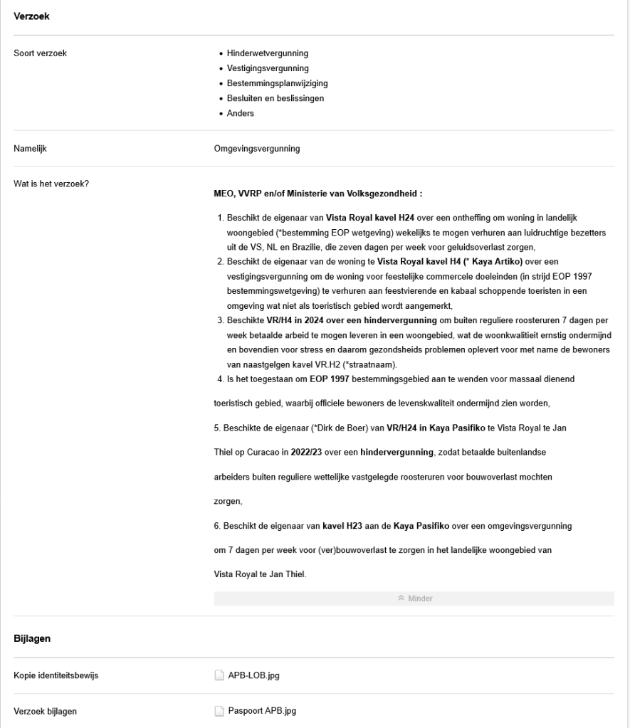
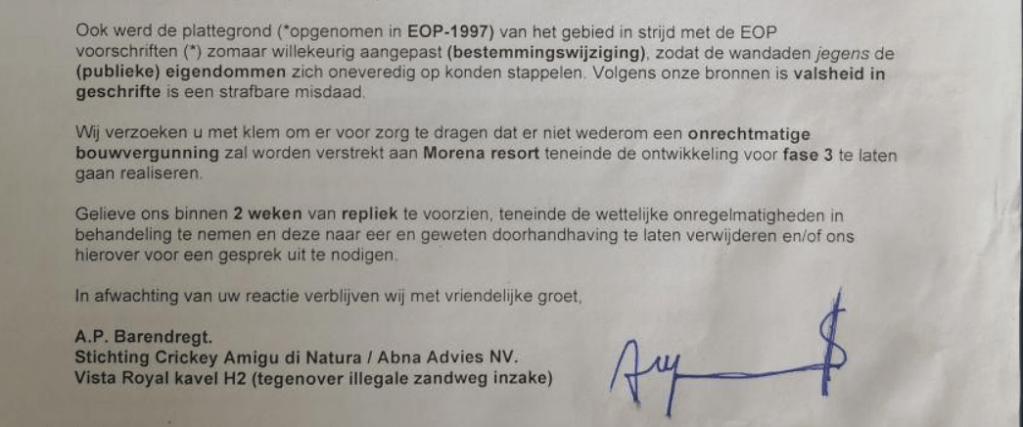
Ook mochten de vervolgens Papagayo/Morena/Chogogo in 2008 een stuk grond in conserveringsgebied, wettelijk vastgelegd in geldende EOP 1997 vastgelegd, waarbij een Bestemmingswijziging nimmer in een Landsbesluit werd vastgelegd door de PAR regering.
Landkaarten werden dus vervalst en voor zoete koek genomen, om de bijbouw in 2008 te kunnen laten plaatsvinden. Omdat alle documentatie via LOB verzoeken door Stichting Crikey Amigu di Natura werd vastgelegd, werd mij letterlijk en figuurlijk de oorlog verklaard, waarbij carte blanche werd werd aangenomen om mijn belangen en bewijzen aan de kant geschoven te krijgen.
Rechtzaak Morena/Abna Advies NV om geluidsoverlast voor de woning van VR/H2 te beperken :
In 2008/09 werd hier door de rechter bepaald dat in een straal van 100 meter geen bouwactiviteiten meer mochten plaatsvinden rondom de woning van VR/H2.
Sluiten bankrekening Wells Fargo (WF) en Banco Popular Puerto Rico (BPPR) :
In 2019-2020 werden de prive bankrekeningen van BPPR op scherp gezet, nadat er klachten werden gelanceerd inzake witwassen van geld. het ging hier om enkele transacties van 100 euro?
Aan de WF account zaten drie safe deposit box verbonden, De bankrekening werd gesloten zonder enige vorm van waarschuwing en/of uitleg. Documenten en waardevoll collecties gingen verloren. Via de Florida claim system was het nog wel mogelijk een bedrag twv $42K te achterhalen en terug te vorderen.
Huurders VR/H24 ingezet om bewoner VR/H2 met grof geweld te verwijderen door geluidsoverlast :
Deze episode kan in de aangifte (KPC dd ……..) worden bekeken.
Aanval op mijn persoon door Belgische bouwvakkers VR/H3 :
Aangifte gedaan dd 10 April 2021.
Roddel op straat over moord plaatsgevonden in de woning van VR/H2 :
Klein Curacao specialisten die met limosine’s rondrijden hadden de directeur dood aangetroffen in haar wonng op Vista Royal, maar dat wordt nu voor het gemak zomaar in mijn schoenen geschoven?
CONCLUSIE :
Aanslagen en terreur wordt niet geschroomd om levenskwaliteit en gezondheid ernstig te blijven ondermijen door betrokken netwerken. Advies gekoppelde derden, verkoop VR/H2 en verdwijn van Curacao om ergens anders een nieuw leven op te bouwen?