
Tropical Storm heading for the Dutch Caribbean Islands and Venezuela

A tropical rainstorm that has been designated as Potential Tropical Cyclone Two by the National Hurricane Center (NHC) is forecast to travel across the southern Caribbean Sea while remaining very close to the shores of Venezuela and Colombia in South America this week.
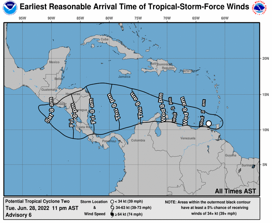
Tropical storm warnings and watches were in effect Tuesday for several Caribbean islands ahead of the developing system’s approach. The storm is fore-casted to pass over the southern Windward Islands Tuesday evening on its track through Venezuela.
While waters are quite warm, dry air is absent and wind shear is low; the rainstorm will struggle with proximity to the large landmass of South America for the balance of this week. In simple terms, wind shear is the presence of strong straight-line breezes that can prevent or limit tropical development.
A hurricane hunter aircraft investigated the storm Monday and satellite images Tuesday morning did not show a strengthening system. Tropical-storm-force wind gusts of 40 mph have been indicated by aircraft in thunderstorms, but satellite images have barely shown any circular motion to the cloud cover thus far.
The northern portion of South America, as well as islands in the southern Caribbean, will be subject to localized heavy rainfall that can lead to flash flooding, as well as gusty winds from strong thunderstorms that can trigger sporadic power outages.

The governments of Venezuela and Colombia issued Tropical Storm Watches for the respective northern coastlines, while warnings remained in effect for Trinidad and Tobago, Grenada, Islas de Margarita, Coche and Cubagua, Bonaire, Curacao and Aruba.
Southern Caribbean islands in the direct path of the tropical rainstorm’s downpours and gusty thunderstorms this week include Trinidad and Tobago, Grenada, Magarita, Bonaire, Curacao and Aruba.
During June, there has never been a named tropical system in more than 150 years of records near the coast of South America during La Niña conditions.

During a La Niña, cool waters over the eastern part of the tropical Pacific tend to alter weather patterns and knock down wind shear over much of the Atlantic basin. This tends to assist with tropical storm development over the Atlantic.
Since record keeping of Atlantic tropical systems began in the mid-1800’s, only 25 storms have passed within 50 nautical miles of Aruba, according to data from the National Oceanic and Atmospheric Administration.
Of those 25 storms, only one brushed by the country during the month of June — an unnamed hurricane on June 29, 1933.
AccuWeather Forecast / Crickey Conservation Society

Nothing happened and nothing will happen anymore, just another fear tactic used to obligatory cage the citizens into their homes for the fun of it?
LikeLike
Looks like the used the Covid-19 lock down tool to be used on a weather phenomenon?
LikeLike
Even the human trade was temporarily stalled as the flying pirate ships of KLM and TUI cancelled their trips in order to cooperate with the fear lock down program on the colonial islands.
LikeLike
That is not true, the KLM and TUI were concerned about the safety of the passengers involved in this weather episode.
LikeLike
Unbelievable?
LikeLike
Fear propaganda to cover up alarming poverty and massive unemployment
LikeLike